


[Editor’s note: This is the first feature in a six-part series exploring life and risk on the Lower Mainland’s floodplain, the stretches of flat land in the region by the Fraser River and the coast. Stay with us this week as the series unfolds.]
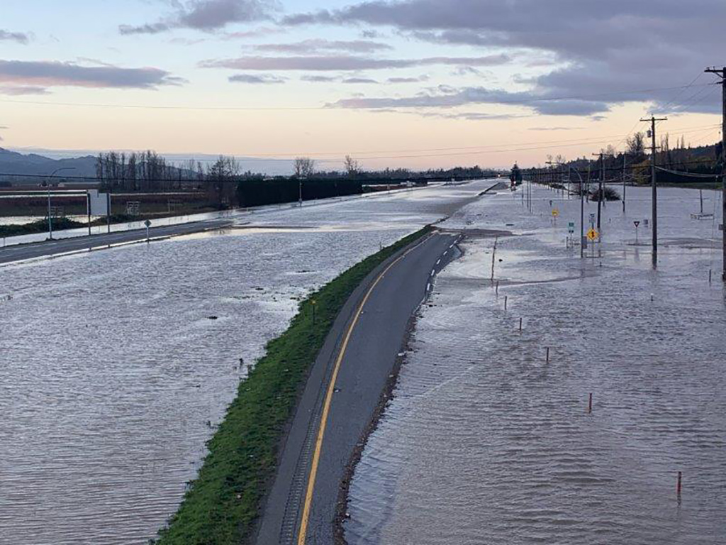
In the early hours of a Tuesday morning in November, the Nooksack River — swollen from record-breaking rainfall — overflowed, crossing the American border and pouring into Canada. Millions of gallons of water overtopped the Sumas dike, spilling into the city of Abbotsford.
Mayor Henry Braun watched the scene later that day from a helicopter. Some of the most fertile farmland in the country is in his city, and here it was being covered by toxic floodwaters, containing everything from oil, gas, asbestos fibres to human and animal waste. “You couldn’t believe the garbage,” said Braun. “Tanks and plastics, stumps and logs of all sizes. It all floated across the prairie and into Canada ‘cause it’s all downhill to Abbotsford.”
Among the toll of the disaster were four people, 428 dairy cows, 12,000 pigs and 628,000 chickens and turkeys. About 420 acres of field crops were hit, representing 4,000 tonnes of vegetables like carrots, cabbage and cauliflower. Over 2,500 acres of productive blueberry crops were hit with floodwaters too, with mature plants needing a decade to grow back.
For the city itself, the cost of fortifying its defenses against future floods could cost as much as $2.8 billion. Harder to quantify in the disaster is the emotional toll on farmers, many of whom have lived and worked on their family properties for generations.
The November scenario, however, wasn’t a surprise. The Nooksack had crossed the border before, flooding Abbotsford back in 1990.
But the big flood that Braun had his eye on — and still does — is in a different direction.
“I’ve always been a little more afraid of the Fraser,” he said. “The Nooksack is a serious river, but it’s a little creek compared to the Fraser.”
So far this year, the province has forecasted minor flooding and a higher flow. This is because of an especially cold spring delaying snowmelt by a month.
Braun always keeps a close watch upriver. “We start seeing things in Prince George and we know that three days later the water will be in Abbotsford,” he said.
It’s been 74 years since the last river flood hit. Experts and elected leaders in the Lower Mainland like Braun are waiting for the next one. And with the effects amplified by climate change, it’s going to be big.
‘Studied to death’
For Tamsin Lyle, the phone has been ringing ever since November. She’s an engineer and flood expert with Ebbwater Consulting, which has worked with communities all over B.C.
So many journalists have been asking her to break down what happened and what’s to come that she created a resource called "Journalists’ Guide to B.C. Flood Reports That No One Read."
It’s a snarky title, but she’s not the only one who feels there’s amnesia around the seriousness of the region’s flood risks, even though the evidence is out there. A meeting earlier this year with the Lower Mainland’s elected officials noted that this subject has been "studied to death."
Lyle compares it with the 2021 movie Don’t Look Up! She related to the scientist characters who try to warn the world about an approaching comet in vain.
“It’s like screaming into the void, with small peaks of interest,” she said.
The next major flood in the Lower Mainland — a river flood like in 1948 or a coastal flood — is expected to be the costliest disaster in Canadian history.
Richer, growing communities are already spending money to fortify their defenses. For the smaller ones without deep pockets, First Nations in particular, there is some federal funding available — but the bad news is that they are the ones most likely to get passed over for the money, according to the auditor general.
Those flood reports that have been sitting around point to one alarming direction: the region is not ready for the floods to come.
Seasonal soak
The Fraser River has its headwaters in the Rocky Mountains, beginning as a tiny trickle. After making its way through canyons and valleys, the Lower Mainland is the final stretch of its 1,375 kilometre journey to the sea.
Major flooding in the low-lying parts of the Lower Mainland, near the river, tends to happen in the spring and in the winter.
In the spring, snow in high elevations melts and flows into the river. This is called freshet and causes the river to run high. During this process, vital nutrients are carried to the ecosystems of the river’s lower reaches, but freshet could lead to a major flood depending how much snow there is and how fast it melts. While it can cause destruction to human habitat, flooding is a natural process.
In the winter, a different kind of flood strikes: on coastlines. They’re caused by storm surges, when wind and air pressure cause high waves and water levels. They can be heightened if they coincide with high tides.
There is a zone called the floodplain — the flat land beside the river and the coast — that could become inundated with water when there’s a big discharge or storm. Humans are at risk because we keep building in these areas.
It’s a Canada-wide problem. Thirty communities with populations over 10,000 are at major risk of flooding. They’ve encroached and altered the floodplain because the location is so desirable, with water access, fertile soil and once-plentiful fish and waterfowl.
In the Lower Mainland, everything from homes, farms, industry to roads are now on these low-lying lands. With colonization, the floodplain has been reduced to about 15 per cent of what it used to be before contact. For salmon, it’s a massive loss of historic habitat for spawning and rearing. Today, over 350,000 people live and work on the floodplain who could be displaced when a flood hits.
Climate change makes things worse. With sea level rise and increasing, intensifying storms, communities have tough choices to make about their future.
The floods last time
There are oral Indigenous accounts of a great flood that covered all the land up to Mount Cheam in Chilliwack and the mountainous peaks we now call Golden Ears in Maple Ridge.
“It rained and rained without ceasing until the rivers overflowed their banks,” according to an account by Katzie Elder Peter Pierre from 1936. “[T]he plains flooded and the people fled for shelter to the mountains where they anchored their canoes to the summits with long ropes of twisted cedar boughs.”
Indigenous peoples kept a close watch on floods on the Fraser River and its tributaries. During freshet, they’d relocate to higher ground, a practice that was discontinued after they were forced onto reserves after the Indian Act of 1876.
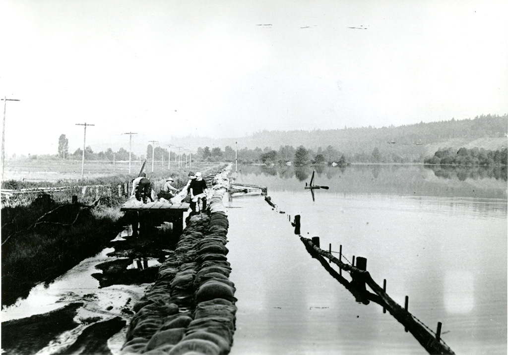
Lower Mainland settlers had their first experience with a major flood when the Fraser River overflowed in 1894, the largest flood on written record. Settler farmers weren’t strangers to the seasonal flows of water, but this freshet was so powerful that it overtopped and breached dikes. It swept away homes and barns. It drowned people, crops and livestock. Six weeks passed before the waters subsided. Premier Theodore Davie said the flood showed “plainly” the need for an extensive system of dikes.
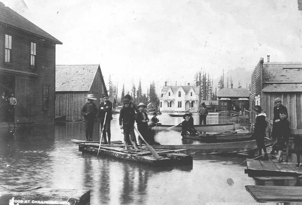
The next largest flood in written record hit in 1948. Once again, it was during the spring freshet and once again, the dikes failed. The flood forced the evacuation of 16,000 people and overwhelmed factories and railway lines. Though smaller than the 1894 flood, it was more damaging because of increased development.
It’s events like these that the region’s leaders are most worried about. November’s storm, called an atmospheric river, caused a once-in-a-generation flood — but it was just a single storm.
The Lower Mainland should experience a flood of 1894’s scale by 2100, according to the Fraser Basin Council, the non-profit that has been studying future floods and plays a key role co-ordinating a flood strategy for the region.
November’s flood is estimated to cost about $9 billion in recovery. The price tag of a major river or coastal flood: up to $30 billion.
Protect, accommodate, retreat, avoid
To help communities make decisions about flooding, a group of University of Waterloo scholars came up with the PARA framework: protect, accommodate, retreat and avoid.
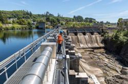
The “protect” approach is very popular in the Lower Mainland. Violent waters? No problem, just build a dike to keep it away from infrastructure. There are about 250 kilometres of dikes in the Lower Mainland, protecting the development in floodplains. The protect approach also includes “softer” engineering approaches, such as expanding beaches or marshes, like Delta and Surrey are doing, to function as a “living dike” that will dissipate the energy of waves. However, these solutions are expensive, often too much for a local government alone.
The protect approach is often based around a colonial mindset, says Kees Lokman, an associate professor of landscape architecture at the University of British Columbia and director of the Coastal Adaptation Lab. Protecting communities means trying to control water instead of understanding that it’s a life force, that there should be a relationship with water that recognizes its right to go places, he says.
Next is the “accommodate” approach, working with the river instead of trying to control it. Think about building a structure on stilts or with a waterproof exterior so that the surrounding land can flood. Without dikes, a river has more room to expand, and during a flood, this slows its flow. If it were channelled with dikes, the flow is stronger and potentially more damaging.
The “retreat” approach means relocating people and infrastructure out of the floodplain. This is often viewed by community members as a last resort and comes with many worries about compensation for property that will be lost, especially in the pricey Lower Mainland region. For Indigenous people who have lived here for millennia and were forced onto reserves, it’s all the more so.
There’s also food security to consider. Most of B.C. is coniferous forests and rocky mountains, not ideal for growing food. Agriculture thrives in the Fraser’s fertile floodplain, home to around 70 per cent of the province’s dairy, vegetables, poultry, eggs, pork, greenhouse vegetables, mushrooms, flowers and nursery products. A retreat could mean stepping back from this level of production.
The “avoid” approach means choosing not to put new infrastructure on the floodplain in the first place. Many communities are doing the opposite and building condo developments right along the water because they want growth and because they believe the protection infrastructure they have is adequate. This is despite reminders from the province and the Fraser Basin Council that all dikes come with a risk of failure; the closer you live to one, the more at risk you are.
These approaches lead to other questions. How might a solution impact the environment? Will a solution be good enough if climate change gets worse? What if an earthquake hits?
Lower Mainland communities were more united after experiencing the 1948 flood, but these days, local governments and First Nations are mostly on their own when it comes to facing floods. The province provides some direction with its dike inspector, dike safety program and Dike Maintenance Act.
An alarming report by the Fraser Basin Council in 2015 found that 71 per cent of assessed dikes would not be able to prevent floodwaters in the event of a river or coastal flood.
The infrastructure that is currently in place is based on measurements from the last century of flooding. With climate change, that baseline is shifting, creating less predictable flood seasons.
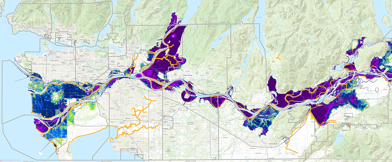
Communities are now eyeing the sea level rise predicted for 2100: an additional metre of water.
That metre makes a huge difference in hectares, according to the Fraser Basin Council.
If we were hit by a major Lower Mainland coastal flood tomorrow, the waters would inundate 54,700 hectares — equivalent to the surface area of five Vancouvers. If the flood were to hit in 2100, an additional 6,300 hectares would be flooded.
Like ‘herding cats’
The challenge of co-ordinating local governments, First Nations and senior levels of government on Lower Mainland flood resilience was compared to first phase of a strategy back in 2016, which provides an overview of flood threats and an audit of existing infrastructure.
But group projects are difficult, especially when the Fraser Basin Council is attempting to create consensus. A second phase, originally due for 2018, is still in the works due to disagreements around goals, funding and jurisdiction. Some First Nations have pulled out of the discussions. At one point, Mayor Braun considered pulling Abbotsford out too, saying that he didn’t want to invest his city’s property taxes into the non-profit if he doesn’t see any “meaningful action.”
“I’m known for being blunt and straightforward. So my straightforward answer to [them], in my whole time as mayor for seven-and-a-half-years: this isn’t working,” Braun told The Tyee.
“It’s not that the Fraser Basin Council is useless; it has a part to play.... [But] there’s so many people involved. If we’re trying to get consensus on everything, we’ll be having meetings till the cows come home. So I’ve not been impressed.”
Once the second phase on a regional strategy is completed, work will focus on a third phase on implementation.
There is some disaster mitigation funding for municipalities from the federal government, but leaders and policy-makers have called the grant system too patchwork and unpredictable.
Braun likened the process to going to a casino in Las Vegas.
Floodproofing the future
So how are floodplain communities faring in this challenging environmental and bureaucratic landscape? Tag along in our series this week as we tour floodplain communities in the region.
In part two, we’ll visit low-lying Delta and meet a couple who lives in a house by the beach that has been deemed uninsurable.
In part three, it’s off for a stroll on Richmond’s “great wall” to see how a boggy island city is managing to urbanize while situated so very close to sea level.
In part four, we’ll head upriver to Pitt Meadows and hear how smaller communities like it have a tough time paying for expensive protections.
In part five, we’ll visit the Musqueam reserve and learn how it and other First Nation reserves have been “landlocked” after colonization in hazardous flood zones.
In the sixth and final part, we investigate what it takes to flood-proof the region and what it might take to “herd” the cats that are its disparate governments.
If you ask Mayor Braun, speaking with fresh experience from an actual flood, it’s time for action.
“When you know what needs to be done, there’s no point in setting up all these committees to study something that we’ve been studying for 30 years.”
Read more: Indigenous, Municipal Politics, Environment


Tyee Commenting Guidelines
Comments that violate guidelines risk being deleted, and violations may result in a temporary or permanent user ban. Maintain the spirit of good conversation to stay in the discussion.
*Please note The Tyee is not a forum for spreading misinformation about COVID-19, denying its existence or minimizing its risk to public health.
Do:
Do not: