


 SHARE:
A discarded cigarette butt, a hot engine brushing up against dry grasses, a spark from a power line. In tinder-dry forests, that’s sometimes all it takes to spark a wildfire.
In B.C., almost 40 per cent of the wildfires that started between 2015 and 2024 were sparked by people — our campfires, our infrastructure, our vehicles. To avoid preventable fires, officials ban campfires, restrict the use of heavy machinery and sometimes prohibit the use of off-road vehicles. But before making those decisions, they need to determine just how bad the fire danger is in the first place.
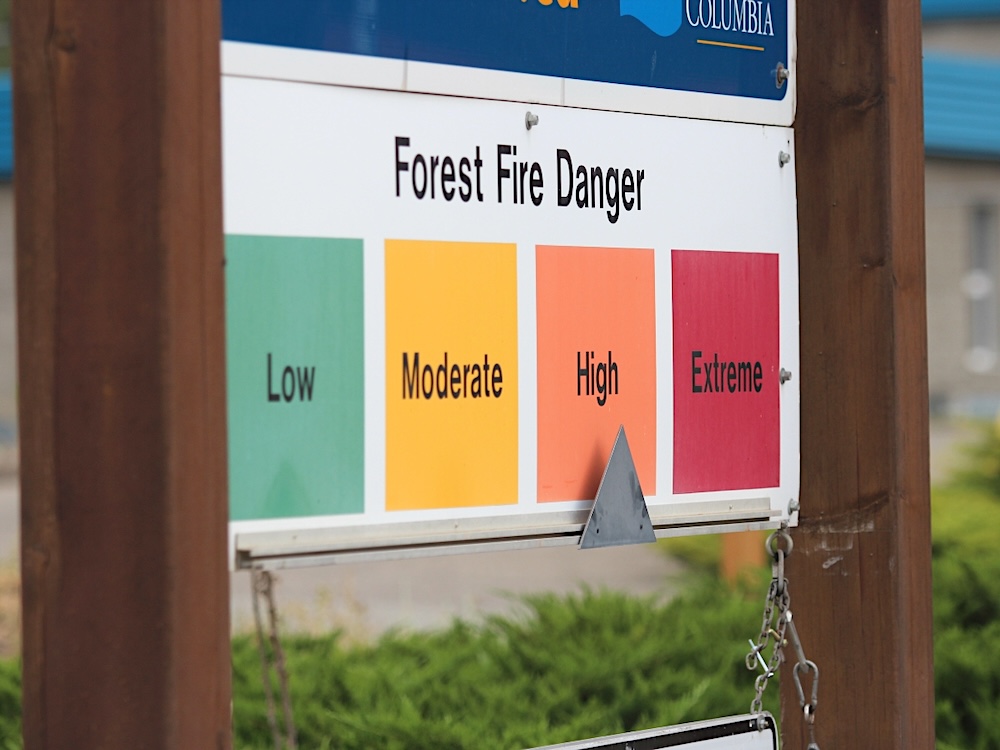
Many people may be familiar with fire danger ratings from online maps or signs stationed at provincial parks, outside local fire halls and on highways leading into small towns.
The billboards, with their green, yellow, orange and red markers that denote different fire danger levels, are simple signs, but there’s a century’s worth of science behind them. And the fire risk they communicate affects how people live and work in B.C.
Industrial activities in dry forests and grasslands are responsible for a chunk of B.C.’s human-caused fires, and as the fire danger climbs, workers face increasing restrictions.
When fire danger is high, the B.C. government requires companies to watch for fire for at least two hours after using grinders, chainsaws or other cutting tools that might produce a spark. The same rules apply to mowing the grass along a right-of-way, felling trees with a machine or a number of other risky activities within 300 metres of forest or grasslands.
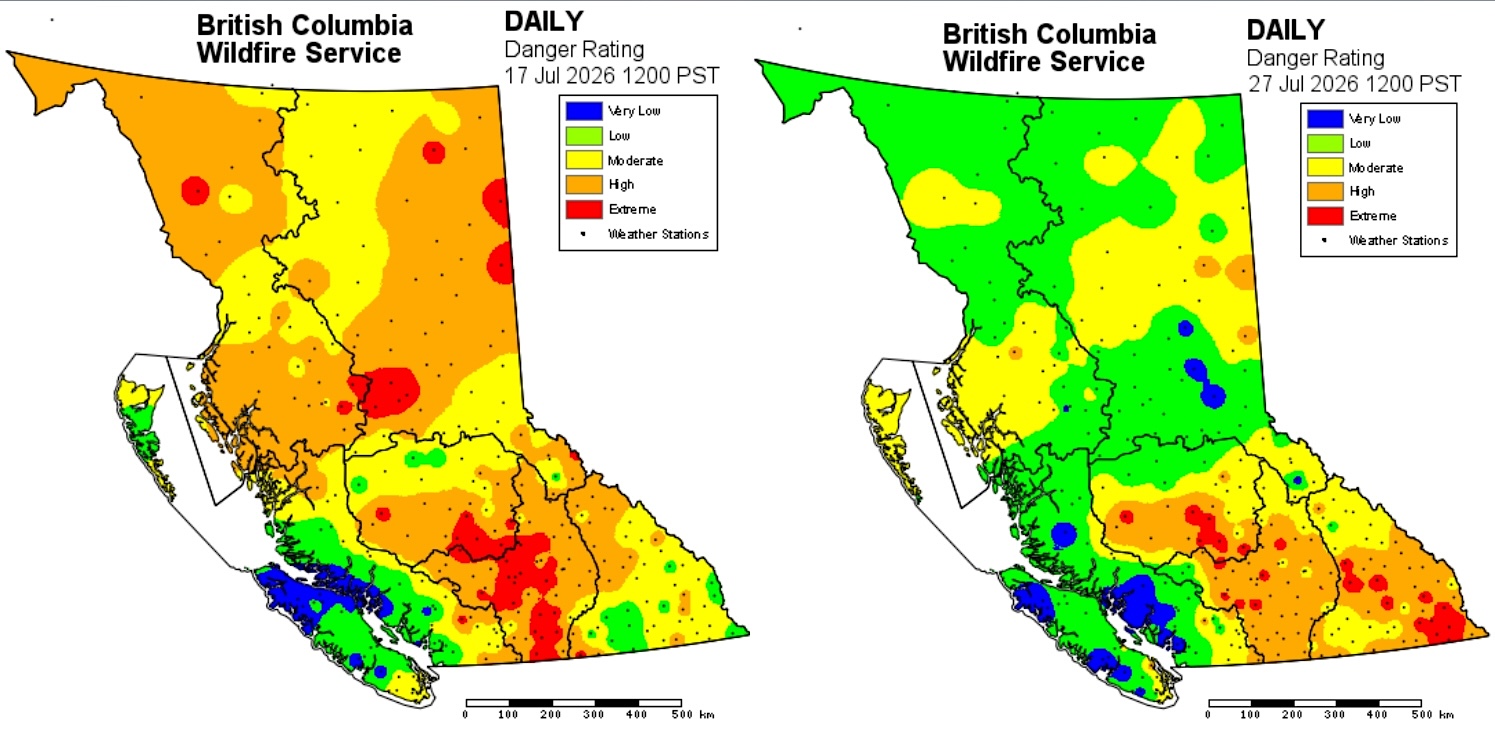
Once the fire danger hits “extreme,” high-risk activities are restricted to morning hours. If the fire danger remains extreme for more than three days, those activities are banned all day long.
Higher fire danger often means restrictions for the general public as well. Lists of these restrictions can be found online and typically involve things like campfire bans and sometimes even limits on backcountry recreation.
Just how flammable is this forest?
Forest fire danger rating research began in Canada in the 1920s with studies in experimental plots to investigate the moisture content and flammability of forest fuels — everything from the fine needles and twigs that litter the forest floor to the deeper organic layers below. Over time, researchers incorporated that work into a series of scientific models now used across Canada and around the world to estimate wildfire danger and fire behaviour.
Fire agencies across the country rely on the national Fire Weather Index System to help determine the fire danger ratings communicated to the public through the familiar roadside signs and online maps.
The system pulls temperature, relative humidity, wind speed, wind direction and rainfall data from automatic weather stations dotted across the country. That data is then fed into models that estimate the dampness of the forest floor at different depths.
Think about the forest after it rains.
“You walk around, it’s squishy and wet — you’re not going to be able to start any fires, whether you want to or not,” Daniel Perrakis, a fire research scientist with the Canadian Forest Service, explained. But the material beneath one’s feet can quickly dry out in the summer sun.
“That’s where the system shines,” Perrakis said. It essentially allows fire managers to track the wetting and drying of the forest floor through three different measures: the fine fuel moisture code, the duff moisture code and the drought code.
The fine fuel moisture code reflects the estimated moisture content of the top layer of needles, grasses and twigs. That topmost layer, Perrakis told The Tyee, is the “most volatile.” It dries out or moistens the fastest as the weather changes, and the code is a key metric for understanding the flammability of fine fuels.
On July 21, for instance, as a new fire grew from a spark to more than 4,000 hectares outside the B.C. community of Boston Bar, the fine fuel moisture code in the area hit the top of the scale, reflecting the extreme volatility of the local forests.
The duff moisture code is an estimate of the moisture in the decayed leaves, needles and twigs just below the surface layer and is particularly useful to determine the flammability of medium-sized branches or other woody debris and the decayed matter a few inches below the surface.
The third measure, the drought code, reflects the moisture content in the deep organic layers and is used to assess the potential for a fire to burn large logs and to smoulder deep into the ground.
The three fuel moisture codes help determine two other key ratings — the Initial Spread Index and the Buildup Index — that help experts estimate how fast a fire could spread if ignited and how much fuel would be available to burn.
In turn, those two ratings determine the Fire Weather Index, a single number meant to reflect the intensity of a fire spreading through a pine forest. As that number increases, fire danger ratings shift from low to extreme, green to red, with slight variations across the country.
For decades, the Fire Weather Index was typically updated once a day. But last year, Natural Resources Canada released a new hourly version that Perrakis says does a better job tracking the moisture of the forest floor and changes in wind over the course of a day.
The new version also allows managers to model fire weather in grasslands, as well as the standard pine forest.
“In a grassland, if it rained two days ago but it’s hot and dry today, basically all the effects of that rain are gone,” Perrakis explained. The grassland model is more reactive to changes in the weather.
The BC Wildfire Service, like other fire agencies across the country, uses the Fire Weather Index System to inform wildfire management decisions.
But it will be a few years before the service adopts the new hourly system, Rick van Kesteren, a fire information officer with the BC Wildfire Service, said in a statement to The Tyee.
“We are collecting data on the [Fire Weather Index] system and analyzing its performance through the fire season, but a lot of work is ahead to incorporate it into our processes,” he said.
For now, the service still relies on the codes and indexes in the old model to forecast potential fire starts each day.
When it comes to deciding when to ban campfires, the service relies on the Buildup Index, the measure of fire-ready fuel in each area. Thresholds vary across B.C. regions, depending on the kinds of forests or grasslands found in the area.
The fire service issues a campfire ban when half the weather stations in the area exceed that threshold.
Municipalities, meanwhile, typically issue their own fire restrictions, which apply within their boundaries. They may align with the BC Wildfire Service orders for the broader region, but they can also be different, accounting for a community’s unique risks.
In the district of North Vancouver, where hillside communities are nestled right up against dense coastal forests, the changing fire danger ratings used to come with “an enormous amount of work,” fire chief Mike Danks told The Tyee.
Different fire danger ratings came with different restrictions that in turn required different public signage to be deployed across the community.
“We were just chasing our tail with this, constantly trying to keep up with it,” he said.
In response, West Vancouver, the city and district of North Vancouver, and Metro Vancouver made the decision to ban open burning and campfires across the North Shore.
“When you look at the trend with climate change, the risk of wildfire, people are hypersensitive about it here on the North Shore — and charcoal is a risk,” Danks said.
“We have been super proactive within the fire service to ensure that all of our staff are trained in wildfire response,” he said, noting they recently sent crews to support the BC Wildfire Service in Boston Bar. “Not only are we helping the province there, but we’re gaining valuable experience if we have a wildfire here, so our staff are already well versed in how to respond to those calls.”
But as wildfire risk increases, it’s not just the fire services that need to be prepared; everyone has a role to play to prevent devastating blazes, from keeping a watch out for errant cigarette butts to fire-smarting your property.
“These are all proactive things that we can do that will make a difference,” Danks said. ![[Tyee]](/design-article.thetyee.ca/ui/img/yellowblob.png)
Read more: Science + Tech, Environment





Tyee Commenting Guidelines
Please note that email notifications for replies are not currently working due to a software issue which may be resolved in a future update.
Comments that violate guidelines risk being deleted, and violations may result in a temporary or permanent user ban. Maintain the spirit of good conversation to stay in the discussion and be patient with moderators. Comments are reviewed regularly but not in real time.
Do:
Do not: