


 SHARE:
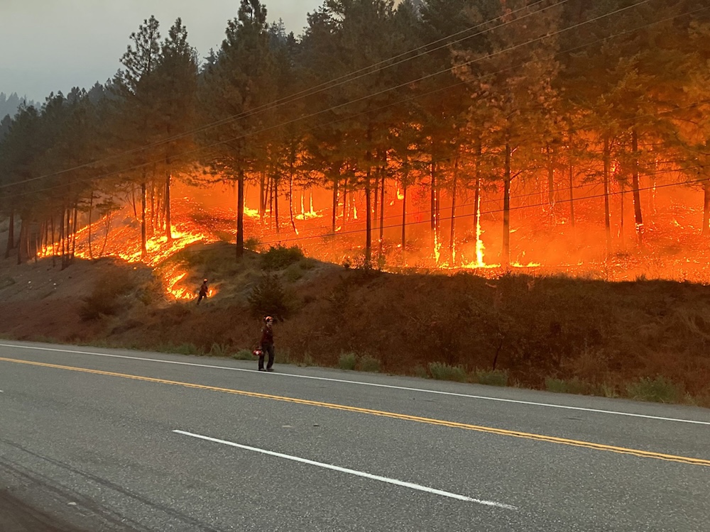
In an era of climate disasters, you can no longer count on a highway to take you where you want to go.
As B.C. grapples with another summer of fire, recent wildfire-related highway closures have shown government still hasn’t fully embraced its role in helping residents navigate our less predictable reality.
On Friday, Highway 97 — the gateway to pretty much all of northern B.C. — was abruptly closed because of a wildfire that was rapidly approaching the village of Clinton.
For locals and close observers, the evacuation of the village and closure of the highway wouldn’t have come as a surprise: Clinton had been under evacuation alert for several days. But for those who lived farther afield, the inability to use the highway may have come as a shock.
Other highways, including Highway 1 through the Fraser Canyon and Highway 3 east of Hope, have also closed with little warning this summer. Widespread wildfire-related closures also took place during the summers of 2021 and 2023.
But even as fire authorities urge travellers to turn to DriveBC, the government-run highway status website, and its suite of social media channels, officials still rarely provide advance warnings that key transportation arteries may close until closures suddenly happen.
The ramifications of a closure can be significant. In the B.C. Interior, people rely on a handful of main highway routes to get to medical appointments, visit loved ones, attend events, make business trips and return home after working in remote locations. Sudden closures can cut off parents from their families, resource workers from their homes, and seniors from medical appointments and prescription pickup locations.
While some of this is unavoidable in today’s conditions, advance notice can allow people to change their plans to rearrange their route or take advantage of the remaining travel window.
Looking at recent improvements by other provincial agencies, we know better is possible.
The problem
Five years ago, I sat in my kitchen and dashed out a series of warnings of the imminent closure of the last remaining connection between two sizable B.C. cities.
It wasn’t exactly difficult.
As the water rose on Sumas Prairie following the 2021 atmospheric river, it became evident that the flooding could soon close the highway connecting Chilliwack and Abbotsford. Thousands of people live in one of the cities and work in the other, and a closure during working hours threatened to leave many, including people I knew, stranded from their families and homes. But even as the water crept higher and higher, and as I warned my colleagues (and social media followers), governmental communicators were silent until water started to lap at the highway and it was abruptly closed. Many were stranded.
This doesn’t stem from a lack of knowledge among government officials, who are familiar with how floodwaters and fires behave in a certain area, and who can predict potential impacts on local transportation corridors.
The problem is instead that our provincial communication channels have historically been only erratically informed by such on-the-ground knowledge and expertise. In particular, transportation communication authorities don’t appear to be regularly in dialogue with emergency information officials.
The progress
There is real evidence that our authorities are adapting and becoming more willing and able to provide their constituents with warning of potential — but not certain — disruptions.
Last winter, when rain poured down on the Fraser Valley, authorities warned travellers that Highway 1 between Chilliwack and Abbotsford might close.
We saw another example of forward thinking Sunday, when authorities with the Thompson-Nicola Regional District said they would be issuing an evacuation order the following day for some residents in the path of the massive Pear Lake fire around Clinton.
“Residents should use the remainder of today to prepare to leave their properties and be ready to depart when the Order comes into effect tomorrow,” the Thompson-Nicola Regional District posted on its Facebook page. The posting was widely shared by both locals and media.
Instead of holding back that information until the documents were signed, as has been the norm, authorities shared what they planned to do with residents, giving them a head start on their preparations to leave.
The warnings highlight a shift in thinking in some government communication spheres and an openness to adapt.
Like flood-related transportation information, fire-related evacuation orders have historically often been issued with little prior warning. Sometimes, this is because of unpredictable fire behaviour. Other times, it’s been the case even when orders were foreseeable by authorities.
An evacuation alert is supposed to be a “heads-up” that an evacuation order is possible, if not always likely. The alert gives people time to collect their valuables, manage plans for pets and livestock and prepare the property they leave behind. But in 2021 and other bad wildfire years, it was not uncommon for evacuation orders to be given before any alert was issued.
Fire is highly dependent on localized and often unpredictable weather. It cannot be known for sure that a fire will “make a run” many kilometres in one direction until it begins doing so. And until recently, such runs were relatively rare. But climate change has altered the dynamic.
For a decade, I’ve closely watched as fires threaten communities near me and as local governments issue evacuation alerts and orders. The frequency with which orders were issued without prior alerts having been given suggested that local governments hadn’t fully processed how today’s climate-change-stoked weather allows flames to cover larger distances much quicker.
But to my eyes, they’ve gotten much better. This year authorities have timed alerts exceedingly well, giving residents in most areas as much time as possible to make preparations.
Now we need our transportation officials to follow suit.
Next steps
The next big challenge is effectively getting information about wildfire threats to travellers moving beyond communities.
The BC Wildfire Service recently urged the public to turn to DriveBC to make their plans, rather than relying on information gleaned through social media, which it said can be outdated and misinformed.
“When it comes to making travel decisions, don't rely on a screenshot, social media comment or an old wildfire update,” BC Wildfire posted on Facebook. “Check DriveBC directly for the latest information before you head out and throughout your journey if conditions are changing.”
But if DriveBC doesn’t provide enough advance warning about future highway conditions, it’s no wonder people turn to Facebook groups to determine just how likely it is that the road they’ll be travelling will become a corridor of flames in the coming hours.
Even as Clinton residents were informed they might soon need to leave their homes, DriveBC was silent about the potential closure of Highway 97, which runs directly through the town. It’s hardly the only such situation.
Two weeks ago, I drove home on Highway 1 through Boston Bar just hours before the community evacuated and that route was also abruptly closed (for a second time this summer) because of encroaching flames.
Today, as I write this, there are evacuation orders for properties along Highway 8 between Merritt and Spences Bridge and along Highway 97 between Williams Lake and 100 Mile House. Both orders suggest the potential for significant fire behaviour along the highway.
If you look at BC Wildfire’s extremely useful map and website, you can get a sense of the danger to those two roads.
DriveBC’s channels, on the other hand, do not currently provide that information to the general public.
When highway closures come late, we often see videos of drivers passing through dicey conditions on highways just before they are closed.
I asked a spokesperson from the Ministry of Transportation about these challenges but didn't hear back by press time. My sense is that tackling them is a work in progress, especially since the solution requires increased co-operation between two separate government agencies.
Some might instinctively find it hard to sympathize with people caught unaware at this point. But people are busy.
If the government of B.C. wants its citizens to rely on official sources when they make decisions about travel and evacuations, it needs to ensure its sources are as informative and up to date as the social media channels with which they are competing.
[Editor’s note: After this story was published, we heard from the Ministry of Transportation and Transit. A spokesperson wrote in an email that the DriveBC map includes a ‘wildfire’ layer that can be toggled on, and that the BC Wildfire Service app also has a traffic layer. The email said that DriveBC ‘provides recent traffic advisories that provide further context if needed, as recently provided for the Highway 3 opening and Highway 1 closure due to wildfire.’
The email added: ‘The Ministry continues to work to improve the new DriveBC platform, listening to users and making enhancements and or adding new features to provide the most value.’] ![[Tyee]](/design-article.thetyee.ca/ui/img/yellowblob.png)
Read more: BC Politics, Environment









Tyee Commenting Guidelines
Please note that email notifications for replies are not currently working due to a software issue which may be resolved in a future update.
Comments that violate guidelines risk being deleted, and violations may result in a temporary or permanent user ban. Maintain the spirit of good conversation to stay in the discussion and be patient with moderators. Comments are reviewed regularly but not in real time.
Do:
Do not: