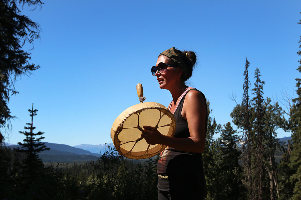
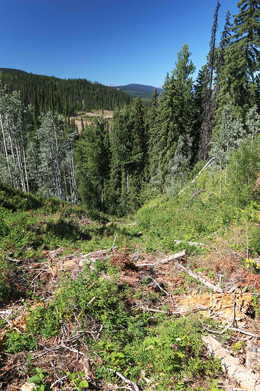
Molly Wickham squats at the precipice above Lamprey Creek. Behind her, the earth tumbles steeply into a ravine. Beyond, Howson Peak sits prominently against a bluebird sky.
It’s a hot day for northern B.C., the thermometer pushing 30 C. Crickets click from the nearby Coastal GasLink right-of-way, a 30-metre-wide cleared swath extending — almost entirely uninterrupted — for more than 500 kilometres to the pipeline’s start in the northeast. The clearing continues across the gully on its journey to Kitimat, more than 100 kilometres to the west.
Just before the pipeline route tips over into Lamprey Creek, it constricts, creating a peninsula of trees — marked by flagging tape — that intrude into the right-of-way. Here, under the canopy of a towering spruce, the ground feels cool and a soft breeze permeates. It’s easy to imagine why past generations would have stopped here, taken in the view and chipped away at a stone tool, leaving clues about the area’s traditional use.
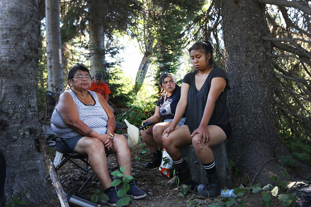
“You’ll find everything you can ever want or need to harvest in this one little area,” says Wickham, a member of the Gidimt’en Clan’s Cas Yikh House. Wickham, who carries the hereditary name Sleydo,’ is sharing information about the area with a small group of Wet’suwet’en youth and Elders gathered at the site.
“It’s a pretty unique ecosystem within our whole territory.”
First Nations have used this ridge for longer than anyone can remember. Just north of where we sit, Lamprey Creek flows into the Morice River (Wedzin Kwa to the Wet’suwet’en) at a traditional village site called Ts’elkay Kwe Ceek. Upstream, sites at McBride and Collins lakes contain house pits, also evidence of past occupation. This ridge connects the sites and would have provided a thoroughfare high above the floods and migrating currents of Lamprey Creek below.
Before it was impacted by logging, the creek below would run “black with lampreys,” Wickham says, providing a staple food for the nation, in addition to the salmon that return to spawn here every fall. There’s evidence that a moose bedded down here, protected by the boughs of the spruce.
“We also see a lot of grizzly bears with young in the area,” Wickham says. “It’s prime grizzly habitat.”
Towering cotton woods and spindly aspen obscure the creek dozens of metres below but allow sunlight to filter through. The gully is thick with huckleberries, soapberries, high-bush cranberry and saskatoon, as well as devil’s club, a traditional medicine.
To the Wet’suwet’en, this site holds clues, pieces of their history on the landscape that dates back millennia.
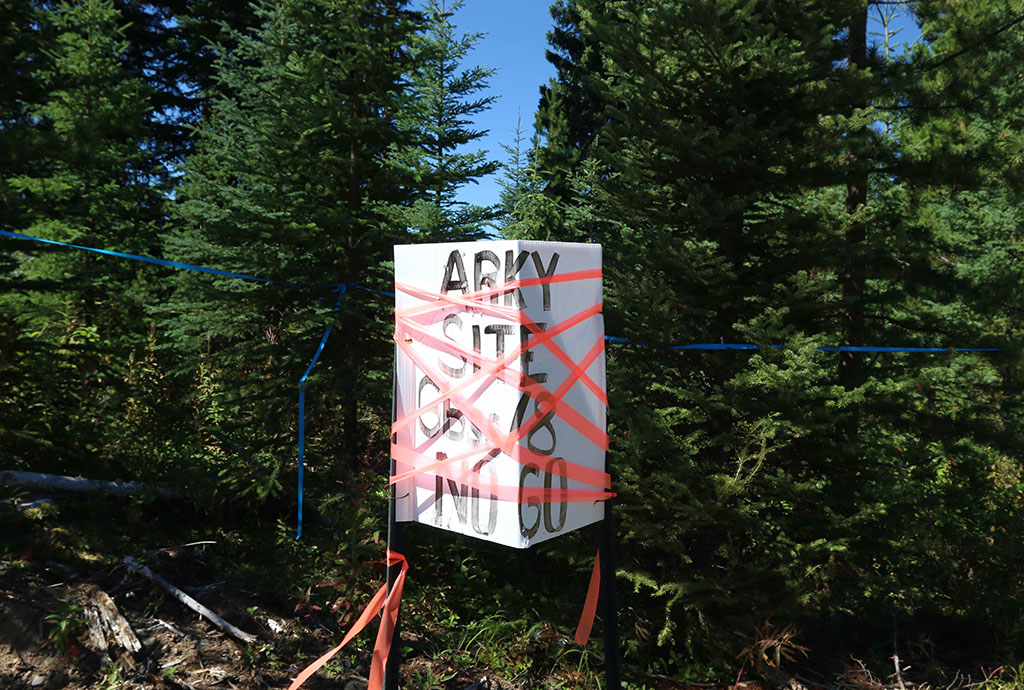
To the B.C. government’s archaeology branch, it is known simply as GbSs-8.
According to a site report by the branch, which regulates B.C.’s cultural heritage, in 2015 archaeologists surveyed the three-by-seven-metre site by digging dozens of small pits, each about a foot in diameter. Two of those test pits revealed evidence of past use that pre-dates European arrival. The archaeologists returned in 2019 and dug five larger pits, this time one metre by one metre, to search for further evidence of past use.
The excavations turned up lithics, material related to stone tools, including an obsidian scraper and flakes, fragments and shatter — pieces that fell away while tools were being chiselled and formed. The obsidian, a volcanic rock sourced hundreds of kilometres away, would have made its way here through a complex trade network with coastal First Nations trading it for local goods like berries and caribou hides.
“It’s evidence of our occupation of this land,” Wickham says. “This is legal evidence of our title. If they come and destroy this, they’re wiping us off this territory. They’re erasing the evidence of us being here. So, it’s really important that it’s protected.”
But in early August, Wickham learned that Coastal GasLink intends to destroy the site during pipeline construction, under the authority of a permit issued by the BC Oil and Gas Commission.
In their 2015 and 2019 reports, archaeologists recommended the pipeline route avoid the site altogether, adding that “if avoidance is not possible, mitigation options will be determined in consultation with the client, Archaeology Branch and relevant First Nations.”
For industry, that means applying for a site alteration permit and potentially hiring archaeologists to recover any remaining artifacts before the site is destroyed.
Issued under the Heritage Conservation Act, the site alteration permit authorizes “the removal of residual archaeological deposits,” according to the province’s website. Though usually issued by the archaeology branch under the Ministry of Forests, the BC Oil and Gas Commission grants permits related to gas development.
In 2016, Coastal GasLink submitted its archeological impact assessment for the pipeline to the province. According to the Oil and Gas Commission, the report identifies sites with high potential for traditional use.
Once identified, any high-potential areas on the pipeline’s path require more investigation before a permit to disturb the site is issued. First Nations are consulted during the application review process for both archaeological impact assessments and site alteration permits, the commission says.
The commission says it referred Coastal GasLink’s site alteration permit application to the Office of the Wet’suwet’en in May 2020 but did not receive any comments. The permit was issued in August last year.
But the Office of the Wet’suwet’en, a Smithers-based non-profit which acts on behalf of the nation’s hereditary Chiefs, says it was not able to access the information, which was encrypted and could not be opened.
“We never received the information and time ran out for the process decision,” says Mike Ridsdale, environmental assessment co-ordinator with the Office of the Wet’suwet’en.
At the time, the nation was undergoing another cultural heritage crisis on its territory, as Coastal GasLink had recently bulldozed a portion of its traditional Kweese War Trail to make way for a work camp for the project.
Work preparing the site stopped until the company had submitted a mitigation plan, according to the commission.
Last July, Coastal GasLink acknowledged that it had begun the work before its archaeological assessments were complete.
“Really, all this work is to do is to see if they can mine out the rest of the artifacts that are there,” Ridsdale says. “It’s not to try and protect it. It is to destroy it.”
Both Ridsdale and Wickham say they haven’t seen a copy of the site alteration permit granted for the site.
When The Tyee requested a copy of the permit, a spokesperson for B.C.’s Ministry of Forests declined on the basis that “its disclosure may result in damage” to the site.
Unlike documents related to the project’s environmental assessment certificate, which are available online, archaeological assessments and permits are not shared publicly due to their content, the Oil and Gas Commission says.
“Archaeological information that is contained in impact assessment reports and site alteration permits are not available publicly due to sensitive information contained within,” communications manager Lannea Parfitt said in an email to The Tyee.
That lack of public access makes tracing a paper trail of cultural heritage management almost impossible, not just for the public but for First Nations whose histories are contained in those documents.
While the opaque nature of cultural heritage management B.C. is intended to protect sites from looting, it also discourages public awareness and oversight, says Joanne Hammond, a Kamloops-based archaeologist who works with the Skeetchestn Indian Band.
“We are keeping a vast amount of super important information from the public here,” she says. “If we continue to hide these 15,000 years of Indigenous history from Canadians, there will continue to be no motivation for reconciliation. People need to... understand the depth and intensity of pre-contact life here in order to be able to understand the scale of the loss that has come from colonization.”
She says the province, and the archaeology branch in particular, will need to integrate B.C.’s Declaration on the Rights of Indigenous Peoples Act and its principles of free, prior and informed consent into decision-making on archaeological site management.
Hammond adds that navigating the system can be daunting, even for the First Nations whose cultural heritage is at stake. Nations are frequently fielding referrals for multiple projects at once, and given that feedback on site alteration permit applications rarely, if ever, results in changes to the outcome, she says nations will be forced to choose where they direct limited resources.
The bigger picture of Indigenous occupation on the landscape is being slowly chipped away in what Hammond calls “a full-on assault on rights and title.”
Wickham says the steepness of Lamprey Creek and proximity to Gidimt’en Camp, where two police actions have taken place in recent years, have delayed clearing here.
“This is the one spot we’ve been able to protect,” she says.
At the site, Chelsey Geralda Armstrong, a Terrace-based archaeologist and Simon Fraser University Indigenous studies assistant professor, examines maps on her phone, noting how the site sits along a trail connecting traditional village sites. She pushes through the area’s thick undergrowth to discover where the trail continues in both directions, to the north and the south, in what was historically a well-used travel route.
“These high, flat ridges — of course that’s where you want to be hanging out. So that’s where the sites are,” she says, adding that the site is part of a trail network that stretched throughout the area. “It’s a hub. For [Coastal GasLink archaeologists] to call this an isolated passing through is just ludicrous.”
Treating the site as independent from its surrounding context omits the bigger picture, she says. Preserving it would allow further research and a better understanding of past occupation in the area.
“Disrupting the site in this way will disrupt the landscape-scale connection all these sites have,” Armstrong says. “There’s been almost no archaeology in what we call the north-interior region of Wet’suwet’en territory. So, some artifacts like this are super important because it allows a bigger picture of an area that’s been wildly understudied.”
It’s unclear what happened to the obsidian tool and other artifacts found at this site or where they are being stored. The ability to analyze them — even from a photo — could provide clues about the site’s age and greater context, Armstrong says.
“It could be 5,000 years old, it could be 400 years old,” she says. “Every region has distinct types of stone tools that they use through time and we can kind of place them into this chronological order.”
In an emailed response to questions from The Tyee, Coastal GasLink says the pipeline’s route has been amended in some cases to reduce adverse effects, including to culturally sensitive areas, but that site alteration permits are used for areas that cannot be avoided.
“Due to the steep slope at this particular location, construction will need to occur through the site to allow for the safe installation of the pipeline crossing at Lamprey Creek,” the company email says. “All work will be conducted under the supervision of a qualified archaeologist to ensure artifacts are recorded and preserved.”
According to the Oil and Gas Commission, the site alteration permit requires that an archaeologist be onsite when a trench is dug to bury the pipeline. It added that Coastal GasLink has also said it will invite First Nations monitors to be present during the work.
When asked whether those monitors will be from the Wet’suwet’en Nation, the commission says that “the site in question includes multiple First Nations and the commission understands that CGL will provide the opportunity for any that wish to be involved at the time of disturbance.”
Though government databases frequently indicate overlapping First Nations and nearby bands as stakeholders, Wickham is clear that GbSs-8 lies squarely within the Cas Yikh House territory.
“We want a copy of that permit and the details of what’s going to happen,” she says. “We insist they cease and desist until we have the chance to actually be consulted on this. They’re not going to do any work until we get the chance to find out what they’re planning to do.”
Coastal GasLink says it has done that.
“We have engaged on this site through the Office of the Wet’suwet’en and welcome participation from Cas Yikh as part of the archaeologist’s monitoring work and have communicated this to the parties involved,” its email reads.
But at GbSs-8, the two parties show no signs of working together.
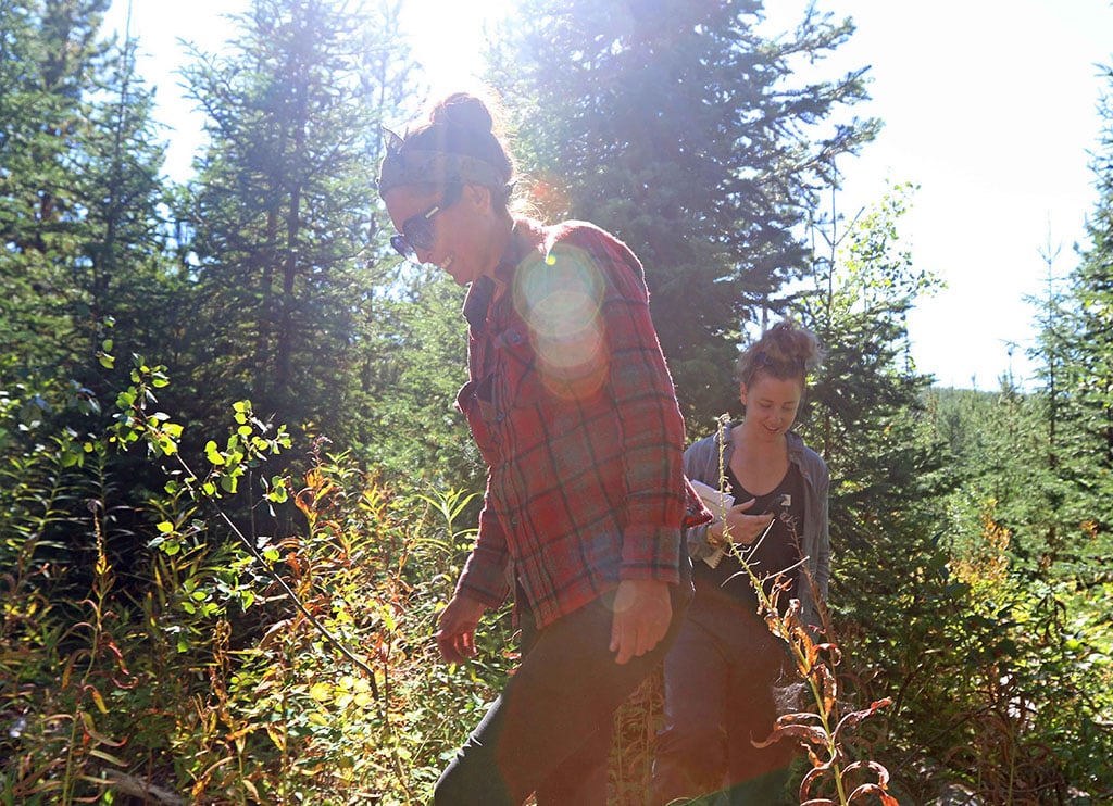
As Wickham speaks, her voice is drowned out by a helicopter flying low, circling once over the group she leads before moving on. Two pickup trucks with Coastal GasLink’s private security have staked out the spot where the youth and Elders in Wickham’s group have parked their vehicles about 100 metres away. The security guards video the procession of vehicles as it leaves the site.
The Oil and Gas Commission says Coastal GasLink is required to give five working days’ notice prior to construction in the area. It has not received that notice, the commission says.
In the meantime, Wickham says Cas Yikh House members will continue to have a daily presence at GbSs-8.
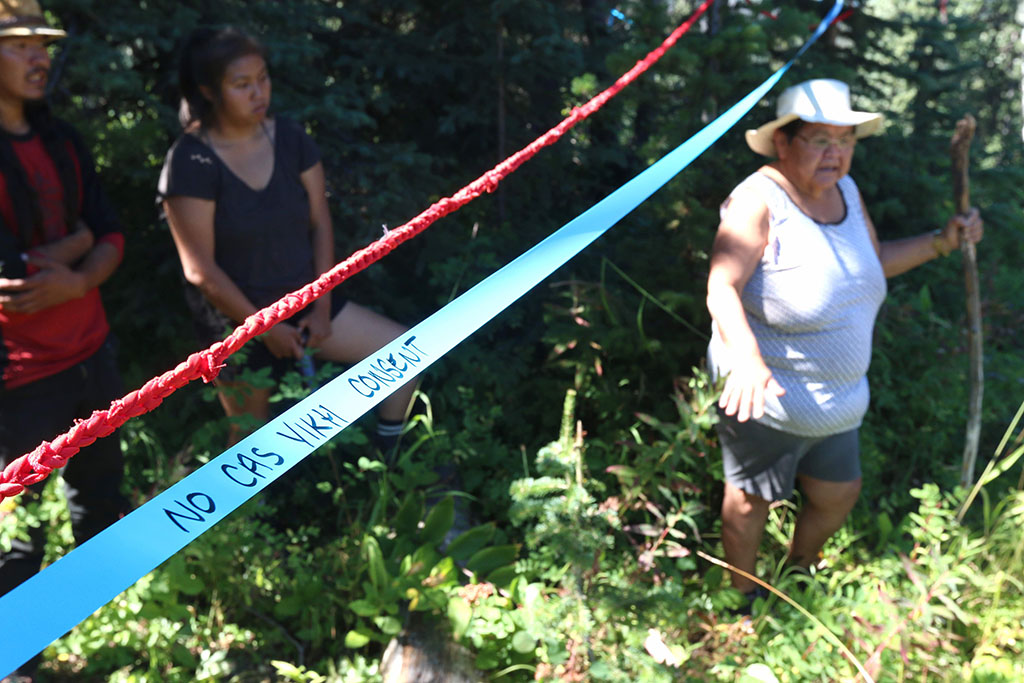
As the area is flagged with more tape marked “No Cas Yikh Consent” and the youths string rope made from red dresses, symbolic of missing and murdered Indigenous women and girls and their connection to industrial projects, Wickham sings and drums.
As Wickham finishes, Elder Janet Williams wipes away tears.
“So much of our territory is already gone,” she says. “It makes me really hurt.” ![]()
Read more: Indigenous, Rights + Justice, Environment








Tyee Commenting Guidelines
Comments that violate guidelines risk being deleted, and violations may result in a temporary or permanent user ban. Maintain the spirit of good conversation to stay in the discussion.
*Please note The Tyee is not a forum for spreading misinformation about COVID-19, denying its existence or minimizing its risk to public health.
Do:
Do not: