


 SHARE:

Some countries and territories, including Canada, Greenland and Russia, will soon look notably smaller on official United Nations maps.
That is due to a recent resolution adopted by the UN General Assembly: “Correct the map: rebalancing global cartographic representation and promoting equitable representation of the world’s regions, particularly Africa.”
This resolution, led by Togo on behalf of the African Union, repairs 450 years of cartographic injustice by recognizing the distortion of the world as mapped through the Mercator projection. It was adopted almost unanimously: 164 votes in favour to one against, with six abstentions. The United States was the sole vote against the resolution.
In 1569, Gerardus Mercator, a multitalented Flemish map-maker who dedicated a large part of his life to drawing and projecting maps as accurately as possible, released a world map that used a clever new method of portraying the Earth on a flat surface.
The major benefit of this projection was its ability to represent rhumb lines (lines of constant compass bearing or direction) as straight lines, providing accurate compass directions for sailors. This was extremely important for Europeans during this period of exploration and colonization.
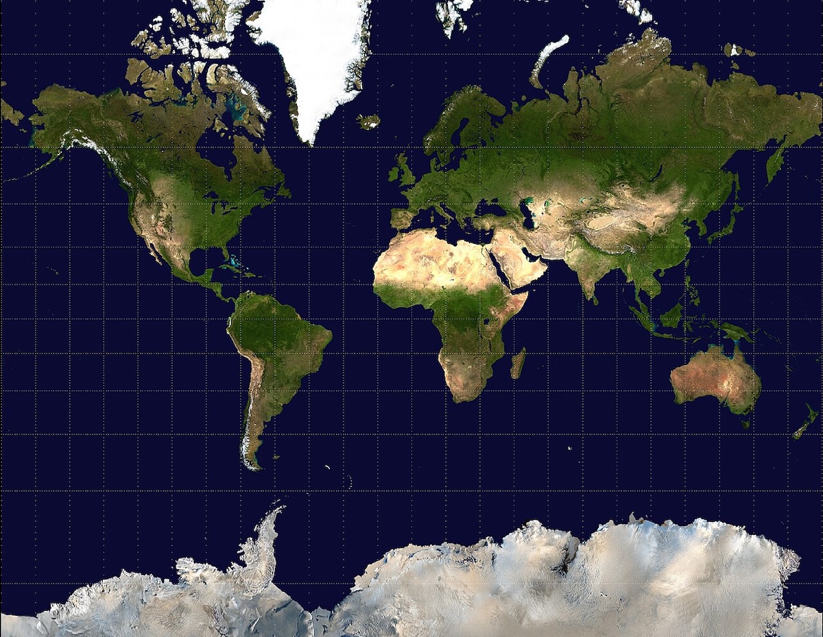
But this improved representation for navigation had a major flaw: it excessively enlarged land masses nearer to the poles. In other words, North America, Russia and Europe appeared much bigger than Africa, South America and South Asia. This became a real issue when this projection, originally designed for navigation, became the de facto projection for all kinds of world maps, including political maps.
Mercator’s projection
Map-makers had known about Mercator’s technical distortion for a long time, but it was only in the 1970s that its embodiment of centuries of colonial ideologies was more broadly revealed.
In 1973, German historian Arno Peters released a new equal-area map projection that completely challenged the Mercator projection and the message it was conveying: Europe is not as big as it appears in the Mercator projection, while its former colonies are much larger.
This type of projection had already been developed previously and was very similar to an 1855 projection made by Scottish clergyman and cartographer James Gall. What was new was the political vision of socially equitable cartography that inspired Peters.
His projection received a flood of criticism, igniting what has been called the “map wars,” but it was adopted by organizations such as Oxfam and UNESCO. These organizations, along with Peters, clearly understood the political importance of map projections and the role maps play not only in representing reality but also in producing it.
The recent UN resolution is another step toward addressing imbalances inherited from the past and “paves the way for greater understanding, respect and peace among nations,” as argued by the representative of Togo.
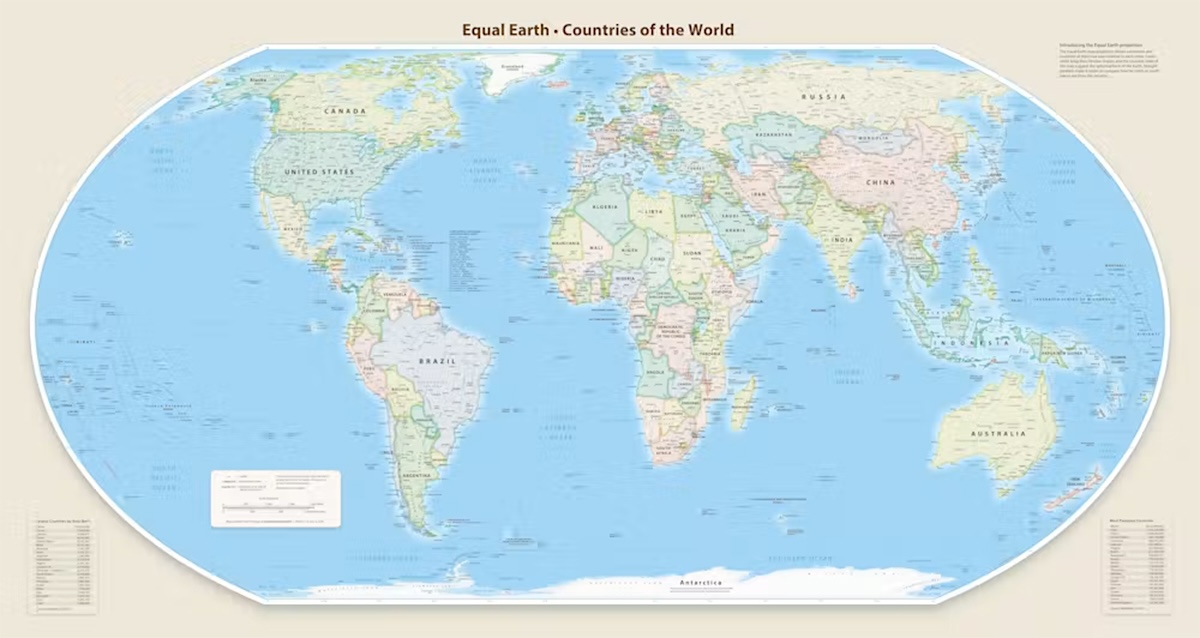
It calls for a proper representation of the world through the adoption of equal-area map projections, particularly the Equal Earth projection, a more recent and less controversial alternative to the Gall-Peters projection. Through this resolution, the UN acknowledges centuries of colonial instrumentalization of the original Mercator projection.
Fairly representing the Earth
Although this resolution will contribute to a renewed vision of the world in schools and institutions across the globe, its impact on online mapping platforms remains to be seen.
The Web Mercator projection, a variant of the original Mercator, remains the default projection of applications such as Google Maps. This projection divides the Earth into squares, making it simple and computationally efficient to zoom smoothly back and forth across the world. It’s precise at the local level, but it also dramatically increases the size of countries closer to the poles.
These maps not only perpetuate the same distorted perspective on the world as the original Mercator projection, but also infuse it with a worldview structured around road networks, business accessibility and the promotion of consumption.
The new representation of the world endorsed by the UN resolution is a clear step toward promoting equitable representation of the world, but it remains an interpretation.
Ukraine abstained from the vote on the “correct the map” resolution. Its representatives said Ukraine “endorses efforts to address historical distortions” but argued that this map legitimizes the “illegal annexation of Crimea by the Russian Federation in 2014.”
Maps influence the world not only through their representation of the size of countries, but also through the kinds of information they emphasize, the technologies they mobilize, the businesses they promote, the ways they name places and the borders they draw.
Perhaps the main lesson from this UN resolution is that we need to be aware that maps are not just banal and inoffensive representations of the world; they are also instruments of power that aim to influence how we see the world and interact with it.
![[Tyee]](/design-article.thetyee.ca/ui/img/yellowblob.png)
Read more: Rights + Justice






Tyee Commenting Guidelines
Please note that email notifications for replies are not currently working due to a software issue which may be resolved in a future update.
Comments that violate guidelines risk being deleted, and violations may result in a temporary or permanent user ban. Maintain the spirit of good conversation to stay in the discussion and be patient with moderators. Comments are reviewed regularly but not in real time.
Do:
Do not: