


Four years after flooding from an American river devastated a British Columbia farming community, Abbotsford’s mayor has little hope the U.S. federal government will fund work that could eliminate the risk of a repeat disaster.
In November 2021, the Nooksack River breached its banks in northern Washington, sending a torrent of water towards the Fraser Valley. The resulting flooding in Abbotsford’s Sumas Prairie closed Highway 1 and a key rail line for a week, killed hundreds of thousands of animals, forced thousands of people from their homes and caused more than $1 billion in damage.
It wasn’t the first time the Nooksack overflowed and flooded into Canada. Flooding occurred on multiple other occasions, including in 1990, when the Nooksack’s waters also closed Highway 1.
Even before the 2021 disaster, officials in Abbotsford hoped they could persuade the Americans to build a dike along the north bank of the Nooksack. But those efforts went nowhere, derailed by worries that keeping the water south of the border would aggravate flooding in low-lying Washington-state communities.
The cross-border political deadlock has never been resolved, and as Abbotsford marks four years since the devastating Sumas Prairie flood, Mayor Ross Siemens says he doesn’t think international co-operation will end the Nooksack’s threat to his community any time soon.
“What's happening down south right now with the trade wars and everything else, we’re not in a good spot,” Siemens told The Tyee.
Siemens said Abbotsford has good working relationships with northern Washington municipalities, the Nooksack Tribal Council and Whatcom County — the government responsible for most of the day-to-day management of the river.
Cross-border talks, which have been ongoing since 2023, have involved local officials, B.C. and Washington state. But the Canadian and U.S. federal governments have not taken part — even when the two countries enjoyed a better relationship before President Donald Trump took office.
That, Siemens says, has been a problem, given the scale of the costs.
“They need to be at the table,” he said.
Siemens wants the Canadian government to refer the issue to the International Joint Commission, a cross-border organization through which the two countries discuss and negotiate solutions to transboundary water issues. Merely referring the issue, however, wouldn’t solve the challenges — both governments would need to come to the table.
Amid the dim prospects of a diplomatic solution to reduce the Nooksack’s flood threat, Siemens continues to angle for more than $1.5 billion in federal Canadian funding to shore up Abbotsford’s flood defences.
A unique river
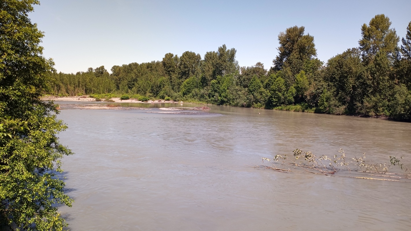
The Nooksack River poses a slew of unique challenges. The river runs entirely through the United States, carrying water west from the slopes of Mount Baker to the Pacific Ocean near Bellingham. As it leaves Mount Baker’s foothills, the Nooksack spills onto a finely balanced flood plain. Near the tiny community of Everson, about 10 kilometres south of the Canadian border, the Nooksack’s channel flows just a few hundred yards from the Fraser River’s own drainage basin.
The river once ran north into Canada and the Fraser River before changing course. (That avulsion may have taken place in a single day, and there is some evidence to suggest it could have occurred as recently as 300 years ago.)
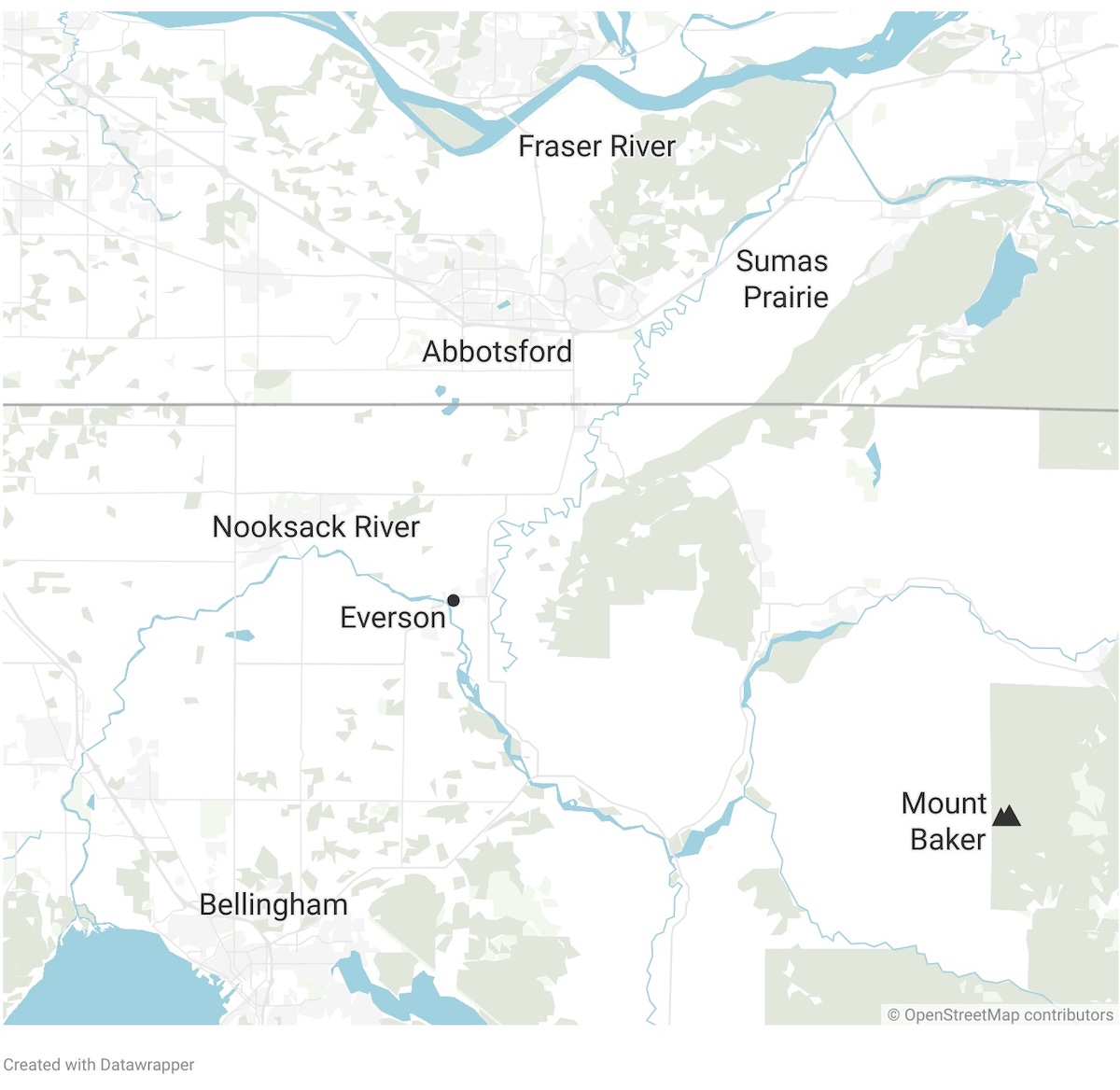
Over the last 150 years, Whatcom County and Sumas Prairie have developed in a regional context in which the Nooksack flows west and north. But on rare occasions — usually following major winter storms — the Nooksack rises so high that it breaches its northern banks, allowing most of its water to escape towards Canada, into the Fraser drainage basin.
The Canadians have long hoped the Americans would raise the dikes on the north side of the river and keep all the Nooksack’s water south of the border. But nothing has been done, in large part because of the worries that stopping the floods into Canada would significantly worsen flooding in communities along the Nooksack’s path. Without considerable work to strengthen flood protections farther downstream, stopping the northbound floods has been deemed to be politically impossible.
Immediately following the 2021 flood, the governments of British Columbia and Washington state pledged to work together to mitigate damage from future floods.
In late 2023, that pledge led to the belated creation of the Transboundary Flood Initiative, a cross-border group that includes officials from both governments, along with representatives from First Nations, the City of Abbotsford and Whatcom County.
Since the initiative’s creation, officials have met to collaborate and co-ordinate policies and technical and infrastructural improvements that could reduce damage from future floods. Those include improving flood warning systems, aligning hydraulic modelling and guiding infrastructure improvements.
Americans in Whatcom County have also discussed and held meetings about potentially altering the “flow split,” as officials call the Canada-U.S. division of floodwaters.
But the talks have not changed the prospects for a flood barrier to stop future floods into Canada, Siemens said. And Siemens doesn’t see success coming without the intervention, co-operation and financial support of both the U.S. and Canadian federal governments.
The egg basket of Abbotsford
To make his argument, Siemens has cited Sumas Prairie’s high food productivity, and the key transportation corridors that cross it.
The relatively small prairie produces a huge amount of British Columbia’s homegrown food. Abbotsford farms produce more than half of B.C.’s eggs, and many of those are laid on Sumas Prairie. The prairie is also home to numerous major dairy farms and thousands of cows. In the northern part of the prairie, where a now-drained lake once dominated the landscape, the soil is so rich as to enable large-scale vegetable production on scales rarely found elsewhere in the province.
“This is the most productive farmland in North America that we're protecting,” Siemens said, pointing to a report commissioned by the local chamber of commerce that per-hectare farm gate receipts exceeded those in Ontario’s Niagara region and California’s Fresno Valley.
Siemens has also emphasized that much of Canada’s cross-country trade crosses the prairie, with goods carried on Highway 1 and the Canadian National line that bisect the narrow corridor.
Siemens says the prairie’s role in food security and goods transportation should make protecting it a matter of national importance and worthy of diplomatic attention like that given to issues related to the Columbia River or Red River, two major cross-border rivers jointly managed by the International Joint Commission. “This is just as important, I would say, as anything that happens in Manitoba or on the Columbia.”
Two countries with different priorities
Today’s discussions echo those that occurred three decades ago. In the wake of the 1990 flood, officials in British Columbia and Washington state convened a task force to tackle the Nooksack’s threat from both sides of the border. Those discussions were open and U.S. officials were “very co-operative,” Neil Peters, B.C.’s former dike inspector, remembered in an interview last year.
But eventually the task force withered and died as memories of the last flood receded — and politics south of the border deterred action there.
“It was just one of these things where government loses interest because it's not in their face,” Peters said. That was particularly true in Washington state, where the number of people who would be helped by reducing northbound flooding is dwarfed by those who might be affected if changes aggravate the flood risk to the west. “The political thing there is weighted far more to maintaining the status quo than solving anything for Canada.”
Today, in Washington state, officials remain focused on finding local ways to mitigate flooding. And officials seem much less eager to involve their own federal government.
In an email, Washington State Department of Ecology communications manager Scarlet Tang wrote that the focus remains on better understanding the river itself and the implications of any potential changes to its course.
“Our work is not just about reducing the amount of floodwaters going to Canada, but also about reducing the risks of floodwaters to all communities on both sides of the border,” Tang wrote. “We all want to get to solutions that will protect both people’s lives and property as well as the natural ecosystem. But before we can develop cross-border solutions, we need to better understand how different solutions might alter flood risks. We cannot simply shift flood risks from one community to another.”
Tang said new models will lead to the development of “specific project designs such as levee setbacks.”
The federal government may play a role funding and approving such projects, but Tang says that would happen after any potential flood protection solutions are developed.
Paula Harris, Whatcom County’s flood planning and mitigation manager, told The Tyee that officials still have much to learn about a complex river that is constantly changing.
“We are learning a lot about the flow split but we’re not at the point to make a lot of decisions,” said Harris. “We’re learning a lot. We’re starting to try and figure out what the implications are — if we do something, how will that affect things.”
Complicating matters is the fact that the river is not a static object, and each year its waters behave differently.
“It’s a changing thing,” Harris said. “It’s changed a lot in the 20 years I’ve been here.”
The challenge within Whatcom County is complicated by the number of towns in close proximity to the river, both west of the flow split and to the north, towards Canada. Human infrastructure isn’t just a potential victim of flooding, it’s also a contributing cause: a bridge at Everson constricts the course of the Nooksack and has been cited as one factor in previous floods.
“We’ve got a lot of things in harm’s way and we didn’t know what we were doing when we built all that stuff in terms of how rivers work,” Harris said.
In a statement, officials with B.C.’s Ministry of Water, Land and Resource Stewardship wrote that the Transboundary Flood Initiative has been focused on information sharing to “support enhanced public safety.” The statement said “discussions around specific mitigation strategies, including those that might respond to the flow split, are complex and require careful discussion.”
The Tyee also sought comments from the Canadian federal government but did not receive a response by its deadline. ![]()
Read more: Politics, Environment


Notice about commenting changes
The Tyee’s commenting system will be moving to a new platform on Nov. 12. If you’re already a Tyee commenter you must register with the new system on or after Nov. 12 with your preferred username.More information can be found here.