


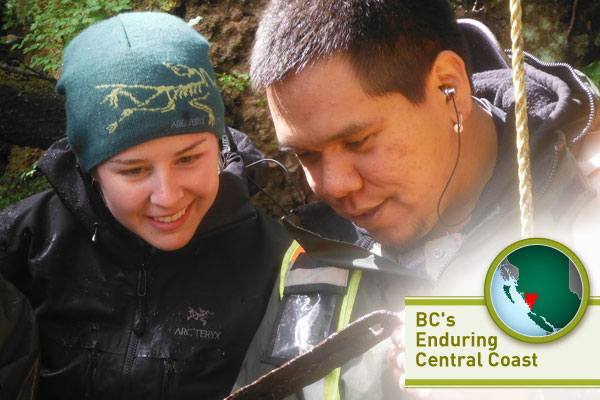
[Editor's note: Earlier this year, a special team of Tyee Solutions Society reporters had the chance to spend some time on B.C's Central Coast. This is their latest report. See the others, here.]
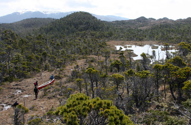
The landscape looks like a giant's bonsai garden. Gnarled trees twist out of the boggy ground; a shallow pond sits in what's left behind of the giant's footprint. The image grows more fantastical when a group of men glide into the picture hauling a canoe, another two trudge through carrying plywood, and a third lopes by shouldering a ladder.
Archaeology on British Columbia's coast is never dull. In this instance, the group is following Duncan McLaren, a University of Victoria (UVic) archaeologist preoccupied with the past of this remote and soggy place, costly to reach and formidable to researchers used to milder landscapes. But it's also a rich place, where the buried past presses close to the surface, evidence of a people's home since the end of the last glacial period over 11,000 calendar years ago.
The discipline of archaeology has traditionally viewed the islands and fjords of the Central Coast as a corridor to somewhere else, imagining it as the route out of Asia to the Americas, speeding travelers on their way to what would become California, Texas, and southern Chile -- a faceless service area on the turnpike heading south.
McLaren belongs to a group of scientists with a different perspective. Their question is not the familiar "Where did people come from and where did they go?" Rather, it's, "How did the people live here so well?"
In contrast to other parts of the continent, which witnessed numerous advances, retreats and replacements of populations, the line from earliest settlers to present-day First Nations in the Pacific Northwest is likely unbroken.
Through oral histories it's fair to assume that until the 19th century, no later arrivals pushed aside or replaced the first peoples. Yes, some New World colonizers moved on, to people North and South America, but others stayed. Over time the climate changed, the landscape changed, and the people changed, but home has been home since the glaciers receded.
Who came first?
A few days earlier I'd driven from Victoria to Port Hardy with two archaeologists -- a casual six-hour lecture from two professors brimming with knowledge and ideas.
Daryl Fedje, not quite 60, retires from Parks Canada this year. He and UVic professor Quentin Mackie, about ten years Fedje's junior, talk shop the entire trip. Somewhere around the turnoff for the Buckley Bay ferry, they mull over potential dig sites in the area, bison bones, short-faced bears, and caves. Physical opposites -- they joke about their Mutt and Jeff appearance -- Fedje and Mackie are on their way to the Hakai Beach Institute on Calvert Island to join McLaren's archaeology team for a week.
The pair are well known for their work on Haida Gwaii, pushing back the dates of the first human settlement of North America. McLaren's work builds on that, peeling back the coastal landscape in a search for the material culture left by the first people to work this land and sea for sustenance at the dawn of the Holocene, the warming period that began about 12,000 years before present (BP).
Over the course of Earth's history, ice sheets have periodically ground across and weighed down continents. Since the start of the Pleistocene 2.5 million years ago -- roughly the same time that our earliest hominim ancestors evolved -- Earth has had several episodes of glacial advance and retreat. Humans have adapted to each change.
During a warming period (an interglacial) ice melts, land bounces back from the weight of ice, sometimes three kilometres thick, and sea levels rise or fall depending on location, re-sculpting coastlines over thousands of years before they stabilize. The wandering seacoasts that result drown some ancient shorelines and leave others high and dry, frustrating the search for evidence of human presence.
Little archaeology has been done on this part of the mainland coast. Two recorded sites, at Namu and another on neighbouring Hunter Island, have been dated to over 9,000 BP. At Bish Cove, 300 kilometres past Namu, in Douglas Channel near Kitimat, stone tools lead archaeologists to think that it, too, dates to the early Holocene. McLaren is betting that his research will turn up many more Namus and Bish Coves. The bet is a good one: the sheltered bays, rich marine life and vegetation lend here themselves to human settlement. As a First Nations elder told me once: only the lazy would starve here.
Past excavations at Namu, and test probes of nearby sites by archaeologists from Simon Fraser (SFU) and McMaster University, have already turned up tantalizing evidence of humans. McLaren's first step was to see if more cultural material lay hidden across the landscape. By the time I arrive, stone tools, burnt bone, and other cultural remains are lined up in neat rows on a table in a Hakai Beach Institute lab. (Like almost all the archaeology being done on the Central Coast, the institute itself is supported entirely by the privately funded Quadra Island-based Tula Foundation.)
Step two is to replicate the 11,410 BP dating of one of those early test probes. The third step will involve in-depth excavations, with the goal of analyzing past populations and pushing back the archaeological clock.
For the past two weeks the crew, based at the Institute, has risen early, gathered lunches, screens, trowels, rope, pumps, hoses, shovels, rain gear, sweaters and hats, and headed out in search of the past. At the start of the third and final week they have lost none of their enthusiasm.
Today, we're on Triquet Island a 30-minute boat ride to the northwest of the Institute. McLaren, a lean 41-year-old, a black wool felt hat — always impressively dirt-free at the start of each day — taming a cloud of dark hair, crouches in a one metre-by one metre test shaft deeper than his almost six foot frame. To reach the pit, the crew holds onto a rope and scrambles up an embankment, a five-metre-high landform almost completely built and shaped by humans.
(To call shell middens "trash heaps" is fundamentally wrong, and it drives archaeologists crazy. Harvested shells supplied a strong, even building foundation and drainage in wet areas.)
Topping the embankment, a short path winds through the trees to the dig. There, water seeps into the test shaft. The deeper McLaren and his colleagues dig, the more water enters. They take turns shoveling mud, placing each layer in buckets, throwing a paper label on top, and hauling them to the beach for screening. "Wet site" archaeology is hard work.
The reward is a better chance of finding well-preserved organic matter however: wood, bark or bone. On the West Coast, most ancient technology was crafted from such organics. Water-saturated finds, from the "bog bodies" of Europe to the tool that Fedje found below the tidal zone at Haida Gwaii over a decade ago, can accelerate the plodding pace of reconstructing the past.
"It's a very rocky, very exposed coast," McLaren tells me, wiping his hands on his pants, standing next to the pit as Fedje starts to dig. "There are not a lot of good places to set up a camp, or any kind of village, or anything like that. Except for when you get to Triquet Island and a few other areas. There are these beautiful beaches; they're a natural magnet for people. They can come in easily with their canoes."
A good place to have lunch
Or, as his colleague Jim Stafford, who did the first reconnaissance of the island, says, "A good place to have lunch is a good place to have lunch."
Especially lunch you can count on.
"That's probably 90 per cent of the reason why this place has been occupied for so long," McLaren continues, gesturing to encompass more than the spot we stand on. "Because one of the major resources here is shellfish, people are harvesting shellfish. You've got beautiful clam beds nearby, you have all these rocks and there are these great mussel beds. So you know you can go out there and if you're hungry here's a quick and easy food source. And a reliable one. It's there all winter when people are waiting for the salmon or whatever to come in."
The archaeologists, I've noticed, at least here, speak about the past in the present tense, the tyranny of a linear chronology abandoned for the cyclical perspective of their collaborators, the First Nations so deeply rooted here through family narratives call nuyems, and the songs and dances that describe the people's cultural connections to the land and sea. The Heiltsuk and Wuikinuxv crew members often share their stories, through ceremonial songs and timeless tales of events that could have happened yesterday or long long ago.
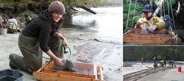
On the beach, Heiltsuk archaeologist Elroy White screens material coming out of the test pit. A generator pumps water through hoses that snake from the bay to the two-millimetre mesh screens, hung by ropes from trees, allowing the crew to stand as they search for artifacts.
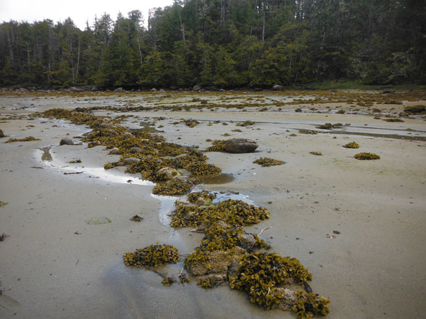
White urges me to walk around a corner of rock, deeper into the bay. There, he says, I'll find one of the many stone fish traps here, the subject of his master's thesis at SFU. "It's still low tide for a while," he warns, "but don't stay too long, you'll be trapped."
Over 250 stone fish traps dot the Central Coast. In his study, White focused on 40 traps, and interviewed community elders about the salmon harvest. "The traps often caught chum for smoke drying," White says. "Not sockeye, like everyone thinks." Chum's lower fat content means it dries well, perfect for winter storage. Sockeye is too fatty; it only becomes good for drying upriver, its fat burned off during its journey to natal streams.
Mud sucks at our feet as Mackie and I walk in search of the trap, chatting about supermarket salmon. Until visiting the Hakai Beach Institute, I'd never eaten chum that I know of. "I think I've only ever had chum canned," Mackie says, before pulling his mind back to the present -- or perhaps a deeper past.
"You know," he says, gazing at the arrow-shaped stone trap across the stream entrances, "this must have been a vibrant place, full of people." We snap photos before heading back.
At the beach, McLaren tells us to pick up the screening pace. Bucket after bucket of mud flows our way, three of us now sifting at each of the three screens, washing out the dirt with a hose, shaking the screen, feeling for artifacts with hands chilled by the cold seawater. Graduate student Jenny Cohen, eyes intent on the task, describes the job as, "hours of tedium punctuated by short bursts of excitement."
Not long after that, Cohen grins. She holds up the find, a wooden artifact that looks like modern plastic needles for repairing fish nets. For a few moments everything stops.
The needle, found two metres below the surface, looks recent, well preserved after thousands of years in an anaerobic environment.
McLaren just laughs when asked how old he thinks the needle actually is. "I'm not guessing, I'll just get burned." Still, it came from a layer below one already dated to 6,200 BP, suggesting it's older still. The only other early Holocene wooden artifacts found on the Northwest Coast came from another wet site: Fedje and Mackie's excavation in Haida Gwaii. An early Holocene date for the wooden needle is an exciting possibility (and in fact, charcoal from the bottom of the test pit is later dated to 10,300 BP.)
Shifting shorelines
Back at the Institute, a couple of days before this season's research ends, McLaren stands before a folding lab table, contemplating the work to come.
"[On Triquet Island] we've got cultural material right to the very bottom essentially sitting on beach sand," he says, handling a stone flake so sharp it looks newly made. Another bit of stone, reminiscent of a baby tooth in the palm of his hand, is the tip of a bifaced blade. Doughnut-shaped stones, made from porous basalt, bring to mind net sinkers, or maybe flywheels. "My feeling is if we went — there's a small channel there — if we went towards that channel there's a good chance there will be a much peatier wet site in there and we may even get better wooden artifact preservation."
Water is something of a bifaced blessing itself. The very thing that preserves spectacular finds, gets in the way of Central Coast archaeology even before the first shovel goes into the ground. To search the landscape efficiently for candidate sites, requires first piecing together the history of sea level changes since glaciation.
That's why one day I find myself one day hauling a canoe through a seldom seen bog forest -- a realm so evocative of a fantasy novel, I almost expect a muttering Gollum to shuffle by — on the slopes of Calvert Island with Fedje, Mackie, McLaren, and Stafford.
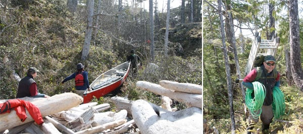
The brush swallows McLaren and Stafford as they take off carrying one canoe. Fedje hauls the other boat. Mackie and I grip the stern, navigating the red boat through clumps of salal, scraping past hemlock trees and bumping over mounds of grasses until we all meet, still far from our destination. We put our packs down, one with a ladder strapped to it, turning back for the plywood.
Once we have the plywood, the process starts again. We operate like a chain gang, and at one point I find myself carrying a sledgehammer. No one complains, even when McLaren steps on an ant nest. The biting, swarming, kind of ant.
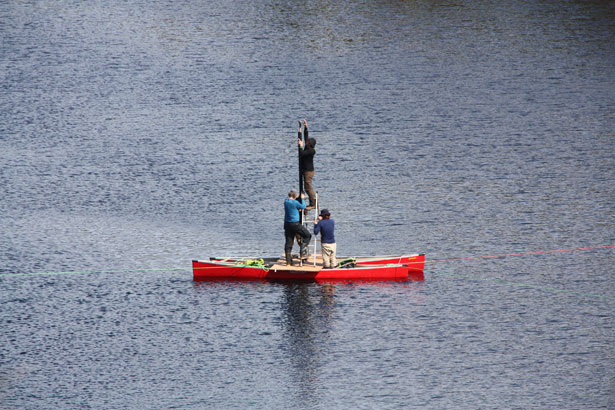
It takes hours, but eventually both canoes, two sheets of plywood, one sledgehammer and a ladder are all at our destination: Stone Beaver Dam Lake.
If the dams here are any indication, beavers rule the bog forest.
The team lashes the canoes together, places the plywood on top and stacks it with the rest of the supplies. They shove off out onto the lake. I scurry over a dam and uphill to take photos. If I meet a wild animal, I hope it's a beaver and not a cougar or wolf.
In the middle of the lake the makeshift catamaran stops. The ladder goes up, the other men holding it while McLaren climbs. From his precarious perch, the scientist sledge hammers lengths of joined plastic tubes straight down into the lakebed. Then he pulls the corer out. The heavy, sodden cores, of course, have to be carried out of the bush along with everything else.
Back at UVic, the dark moist cylinders will be searched centimeter by centimetre for pollen grains and diatoms whose identities reconstruct the past. Fedje sneaks a quick look in the Institute lab.
"Well," he says, peering into the microscope, momentarily Merlin, moving backwards in time. "About 13,000 years ago this place was open, tundra-like but not tundra. It had willows, sedges, and grasses. There's some pine pollen here but when there's pine in the ecosystem it dominates, 99 per cent of the pollen will be pine. It's prolific. If a sample has less than 50 per cent pine pollen [like this], it's not a pine environment. It blows in."
At the very bottom of the core -- its oldest layer -- is glacial clay. That suggests to Fedje that here on Calvert Island the sea level has been below the bog's present elevation, 10-metres above the barnacle line since near-glacial times. It's one of the first puzzle pieces for the Central Coast's sea-level history map. "It's exciting," Fedje says. "This is a puzzle no one else has solved yet."
Life before cedar
Another puzzle relates to cedar, a staple resource for coastal First Nations for thousands of years. What did they use before cedar spread across the landscape, only about 5,000 years ago? Woven beach grass is common in cedar-less environments like the Aleutian Islands. And the test pit at Triquet Island yielded long, wide strands of grass.
"It's very cool and I'm very excited about that," McLaren says. It's a few weeks later and we're in a lab at UVic's archaeology department, poring over a couple of trays of stone tools. Refrigeration units in a closet next door hold artifacts like the wooden needle, and samples like the lake cores; unless it's kept cool and dark, organic material tends to grow stuff.
"I'm wondering, when we pulled up some of those chunks of grass -- it looked like tule grass -- if there is pattern to it, has it been woven?" McLaren muses as we put the trays away and head to the refrigerators. "So I think if we get some early [carbon] dates, we'll probably go back to the site. Now that we know that there are these preserved wooden artifacts, a possibility for fibre preservation and also the possibility for woven objects, we can go back more meticulously."
Chronicling human adaptation to environmental change gives archaeologists an idea of what resilience looks like in action. That drives McLaren and others to look past their colleagues' fixation on the coast as a corridor to elsewhere.
"If we look at how people interacted with their environments we can learn a bit from that, and I think one of the better examples of that I've come across is the fish traps," McLaren says, easing open the refrigeration unit's door to show me the lake cores nestled inside. "They would've experimented with a lot of different things, and if it didn't work they would've dropped it fairly quickly."
I'm reminded of the last day in the field with them. We scoured Gosling Island, a rocky outcrop attached at low tide to Goose Island.
McLaren and Stafford hiked over mossy humps, pausing every now and then to jam an auger into the earth, twist and pull up short mini-cores. They hoped for bits of shell, charcoal, any hint of a cultural layer below. Others strolled the intertidal zone, heads down, picking up and discarding flecks of stone that might have been worked by people long ago, pausing to assess whether a certain line of rocks could have been moved to make room for a canoe haul.
The boat was due back shortly. A few of us sprawled against logs on the beach. I sat with my face to the sun and listened to Josh Vickers.
He told me how the maker created the people here on these islands. When he talks he gestures to the sky, to the ocean on either side of the beach, explaining the gifts that came to his Heiltsuk ancestors one after the other. Trees. Fish. Other people.
It's not the kind of story told by people just passing through.
Yesterday the "BC's Enduring Central Coast" series kicked off with an overview of the region's ecosystem and residents' resilient ties to the sea, plus this video about Heiltsuk people reclaiming ancestors' remains taken by archeologists decades ago.
Tomorrow: A timeline for BC's Enduring Central Coast, and how to build a sustainable research centre on wild, remote Calvert Island.
The entire multi-part series is collected here as each part is published this week.
Tags: Environment, Food ![]()
Read more: Indigenous, Food, Environment


Tyee Commenting Guidelines
Comments that violate guidelines risk being deleted, and violations may result in a temporary or permanent user ban. Maintain the spirit of good conversation to stay in the discussion.
*Please note The Tyee is not a forum for spreading misinformation about COVID-19, denying its existence or minimizing its risk to public health.
Do:
Do not: