


[Editor's note: This is the fourth excerpt from Patrick Condon's new book Seven Rules for Sustainable Communities: Design Strategies for the Post Carbon World. This series, running Wednesdays and Thursdays for four weeks, offers just a sampling of Condon's vital guide for green planning; interested readers are encouraged to seek out the book.]
Many believe that electric cars and windmills will solve the climate change crisis, with no need for fundamental change in city form. This belief excludes an acknowledgment of the gargantuan energy and material demands consequent to such an ever more sprawling metropolitan pattern.
Prof. William Rees of UBC, co-inventor of the ecological footprint concept, maintains that we are, as a species, already in "ecological overshoot" mode. Ecological overshoot is the point at which human activities are draining down more resources from the planet than the planet can resupply.
In Rees's estimation, we are "draining down" the planet's "capital" now. Even more depressing, he also maintains that if every person on the planet enjoyed the same consumption levels as North Americans, it would take six planets to supply them.
And these calculations do not even include the consequences of greenhouse gas buildup in the atmosphere, and the extent to which climate change would further drain the planet's "capital" resources and the ecological services that the planet can supply.
Accepting these calculations then, a much more radical restructuring is required, as technology and manufacturing cannot save us. In fact, they are what created the problem in the first place.
The conclusion is inescapable. The per capita consumption of materials and energy must be dramatically cut if we are to find a balance with the planet's ability to supply them.
Since 80 per cent of North Americans now live in cities, it follows that the form and function of the city, along with the resource content of the food and material goods that flow into it for our use, must be substantially changed.
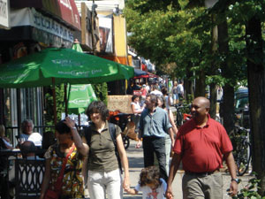
Given that getting from one place in the car to another is responsible for up to 40 per cent of the problem, and that walking is a zero carbon substitute, a careful look at walking seems like a good place to start.
When it's easier to walk
In our current situation, in which the car is always at hand, North Americans will walk only if it is easier than driving. The break point for walking trips seems to be five minutes, which is enough time to walk approximately one quarter mile, or 400 metres.
Most people think that walking five minutes is easier then firing up the car, pulling it out of a parking space, negotiating streets, finding a place to park and exiting from the auto driver's crouch.
Humans are incredibly sensitive to the minor benefits and costs of choosing one mode over the other, no matter how short the trip. Naturally, some people will choose to make longer walks, while others will opt for the car even if the walk is ridiculously short, but the average threshold for walking is five minutes.
But the five-minute walk rule is meaningless if there is no place to walk to. Many new suburban developments are equipped with walking trails, but while these trails may be used every day by people who are in the habit of walking and jogging for exercise, the average person will use them much less regularly if at all.
For the average person, the most compelling destination for regular walking is the corner store. If a convenience store is located less than a five-minute walk from home, the average person will walk there many times a week to pick up bread, eggs, milk, newspapers and many other impulse items.
In suburban-sprawl locations, there is a different kind of five-minute rule in play. There you will usually find "gas and go" stores distributed evenly throughout the suburban matrix, but at a five-minute driving distance; these stores are usually inaccessible on foot, further exacerbating auto dependence in these landscapes.
Walking more, driving less
If the basic corner store is joined by a video rental, hair stylist, tavern and cafés, then it is that much more likely that walking will be a daily part of life for nearby residents. If conditions are perfect, these stores will be joined by coffee shops, hardware stores, used book stores, fruit and vegetable stands, pizza shops, accountants, dentists and the local grocery store.
When most of residents' daily commercial needs can be met within walking distance, not only do they walk more but they use the car significantly less. Residents of Vancouver, for example, where most residents can satisfy their daily commercial needs on nearby streetcar arterials, use their cars over 30 per cent less than do residents of South Surrey/Langley, a car-oriented community.
Residents of Vancouver also own fewer cars, 1.25 per family compared to 1.7 per family in Surrey. Access to commercial services and frequent transit seems to explain these differences, as average family income in the two communities is nearly the same.
Among sustainable community advocates, the five-minute walk rule has become axiomatic. However, it is usually imagined and applied as a walking distance radius or a circle surrounding some fixed commercial point. This is indeed the way it works if there is only a small commercial node with one or two stores, but in Vancouver and other vibrant streetcar cities, commercial activities spread many miles along the streetcar arterial.
Where this occurs, the five-minute walk is no longer a circle but, rather, a continuous band that extends a quarter mile perpendicular in both directions to the streetcar arterial. The basic pattern for streetcar cities is a grid of streetcar arterials spaced at half-mile intervals. This means that everyone will be within a five-minute or quarter-mile walk of some streetcar arterial, and often able to choose between two.
These long linear commercial corridors comprise the bulk of public realm spaces in streetcar cities. This linear public realm, so characteristic of most Canadian and U.S. cities, has implications for our understanding of their qualitative aspects -- their "sense of place."
Transit, density and the five-minute walk
Transit has a synergistic relationship with pedestrian-dependent commercial services. If the solitary corner store has a bus stop outside, both the store and the transit service are enhanced.
The store is enhanced when bus riders pop in to buy a newspaper before jumping on the bus. The transit service is enhanced because riders can now use the trip to the bus to do more than one thing -- ride to work and pick up the paper, ride back from work and pick up milk -- making the bus that much more attractive.
The more commercial functions at the stop the better, as this makes it even more possible to "trip chain" meaning to perform more than one errand on the same trip.
On streetcar arterials, trip chaining is even easier. Riders can hop off the bus or streetcar to stop at the pharmacy, the toy store, the electronics store or the wine shop and then hop back on to continue their trip home.
In this way, stores located along highly functional streetcar corridors gain customers from both the pedestrians who walk from nearby homes and the transit users passing by on the corridor. Some of these synergies also accrue to developments that are commonly known as transit-oriented developments (TODs), although as pointed out previously, anyone who lives outside a five-minute or at most a ten-minute walk from the centre of the TOD will not gain these advantages.
Only through chaining TODs in a pattern can these advantages be equally available. The streetcar city corridor is the simplest way to chain TODs in a pattern that is universally accessible.
Designing for the bus or streetcar
At headways (or frequencies, the length of time between one bus leaving and the next arriving) of seven minutes or less, users no longer need to consult schedules. They know that their wait will be four minutes on average -- sometimes less, sometimes more -- but never more than seven minutes.
These waits are insignificant in the minds of most riders, making it that much more likely they will use transit. For this reason, many transit authorities make achieving seven-minute headways their Holy Grail.
In suburban areas of Vancouver, the transit authority has provided bus service within 400 metres of almost all homes (thanks to the legacy of the agricultural grid and its quarter-section roads on the half-mile interval), although this is often as the crow flies.
But the dendritic street system of "loops and lollipops" inside the half-mile super blocks often forces walks of ten minutes or more. Given the low riderships characteristically generated by these suburban landscapes, regional transit authorities cannot justify buses at seven-minute headways.
More typically, they are at thirty-minute intervals and in some cases an hour. In low-density landscapes dominated by the dendritic pattern, destinations usually require one or two transfers, thus taking many times longer than car trips. Furthermore, stops at the most common suburban destinations, such as shopping malls, are notoriously unfriendly for transit customers.
With so many disincentives for transit built into the suburban dendritic street system, it is no surprise that transit captures only a few percentage points of all trips in such landscapes. Short of a major and gradual urban retrofit, nothing short of $10-per-gallon gasoline is likely to change this.
Waiting and waiting for the bus
With so few customers to serve per square mile in such landscapes, transit officials are hard-pressed to provide frequent transit. At these headways, users must organize their whole day around the schedule of the bus, not just on their departure trip but also on their return.
Long headways combined with long multiseat trips and pedestrian-unfriendly destinations make it unlikely that residents with a car will choose transit, and they don't. The large majority of transit users in most suburban areas are the infirm, the young and those too poor to own a car.
Conversely, in streetcar cities, this kind of entropy toward failure is reversed. Features of the landscape conspire to reinforce pedestrian and transit use, making it more and more likely that residents will choose transit for its convenience and economy, resulting in a more efficient transit system, more revenue for the transit agency, and a compelling justification to reduce headways on the corridor even more.
But the key factor in this success is density.
More people means better transit
It is now accepted that the higher the density in a service area, the more likely it is that residents will use transit. Evidence for this comes from analysis of real places. Almost everyone in high-density Manhattan uses transit; almost no one in low-density, sprawling Phoenix does.
A density of 10 dwelling units per gross acre, or 25 residents per gross acre, is the usual minimum standard for frequent bus service. This guideline is borne out by transit ridership figures from the Vancouver region, where the average density is between 10 and 15 dwelling units per acre. Here, less than 50 per cent of all commuters use the single-passenger automobile to get to work.
Conversely, in third-ring suburban locations, such as Coquitlam, British Columbia, where gross density is less than five dwelling units per gross acre, and despite the availability of express buses, more than 90 per cent of all commuters get to work in the single-passenger automobile.
While density is the most important factor influencing transit use, other more subtle factors also have an influence. An interconnected street network, which helps users get to buses; the even distribution of commercial services along streetcar arterials, which makes trip chaining possible; and lots of jobs located on the corridor all play a crucial role, but have proven more difficult for researchers to definitively link to ridership.
If the average density of a very large area – say, greater than 10,000 acres or 15 square miles – is 10 dwelling units per acre or more, and if this area is balanced with one job per household, and if there are convenient transit connections to the larger metropolitan region, and if a full range of commercial services is available in the district, then transit may be able to provide an alternative to the car.
That's a lot of ifs. Fortunately, many streetcar city areas already meet these criteria, and many suburban areas, as they mature, are approaching those thresholds as well.
Adding density
Most U.S. and Canadian suburbs start out with average densities of between one and four dwelling units per gross acre. Newer suburban areas in many parts of the U.S. -- Las Vegas for example -- are higher, at about six dwelling units per gross acre.
Other metropolitan areas are finding ways to add density to previously built low-density areas. Vancouver and Portland, for example, are adding density and jobs to formerly car-dependent areas in numbers that make it possible to provide additional transit service and anticipate viable commercial services within walking distance from most homes, in locations that could not previously support them.
Ten dwelling units per acre is the accepted figure at which buses can be economically supplied at short headways. For streetcars or trams, the accepted figure is closer to twice that.
Densities of 17 to 25 dwelling units per gross acre are not uncommon in streetcar cities and not unachievable in new communities. Also, as discussed earlier, there are many reasons other than ridership for investing in the streetcar, which may make the streetcar an intelligent economic development strategy at average densities between 10 and 20 dwelling units per gross acre.
Trams or modern streetcars cost less to install and run than buses if you look at the 30-year amortization costs. And trams, no matter what the power source, produce only a fraction of the GHG per passenger mile that diesel buses do.
Life without a car
All of our national attempts to substantially reduce GHG will fail unless we can change the local aspects, unless we can make walking and taking transit easier than driving. And this will be possible only if the things we need and want every day are within a five-minute walk.
If this five-minute walk brings us to zones where buses and streetcars abound, then it becomes equally convenient to hop on and hop off regularly, until at some point life without a car seems like not such a bad idea.
None of this works without a balance among density, street network, frequent bus and streetcar headways, and even sensible locations for schools. Miss one of these components, and you compromise the others. Streetcar city models provide many lessons for reapplying to other newer contexts, and they impel us to protect these features in landscapes where they are threatened.
Creating new communities and retrofitting old ones for walkability and alternatives to the car will be the challenge of our time. The various monumental pathologies identified earlier have their source in what seems like a humble decision. Should I drive to get that loaf of bread, or can I walk?
That decision amplified and repeated by many millions results in impossibly overloaded freeways and ridiculously expensive and unsustainable patterns of movement. Reconstructing our urban landscapes around the five-minute walk is a key part of restoring their health.
Next Wednesday: Rule 4 – Locate good jobs close to affordable homes. ![]()
Read more: Transportation


Tyee Commenting Guidelines
Comments that violate guidelines risk being deleted, and violations may result in a temporary or permanent user ban. Maintain the spirit of good conversation to stay in the discussion.
*Please note The Tyee is not a forum for spreading misinformation about COVID-19, denying its existence or minimizing its risk to public health.
Do:
Do not: