


In 1990, workers excavating land at Squamish’s garbage dump made a curious discovery: trees buried deep in the ground.
The dump’s operator called in geoscientists, who dug five metres and unearthed not just a few logs, but an entire forest. The trees and surrounding debris turned out to be evidence of an 800-year-old landslide that had cascaded down the slopes of Mount Garibaldi and flattened and buried the landscape. Scientists soon determined that the slide wasn’t the largest debris slide to have tumbled down the iconic mountain’s southwest flank and into the valley. And they knew then that it wouldn’t be the last.
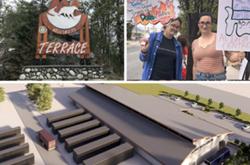
Today, three decades and multiple studies, reports and expert panels later, one of North America’s most ambitious disaster-prevention projects is taking shape uphill of the dump site.
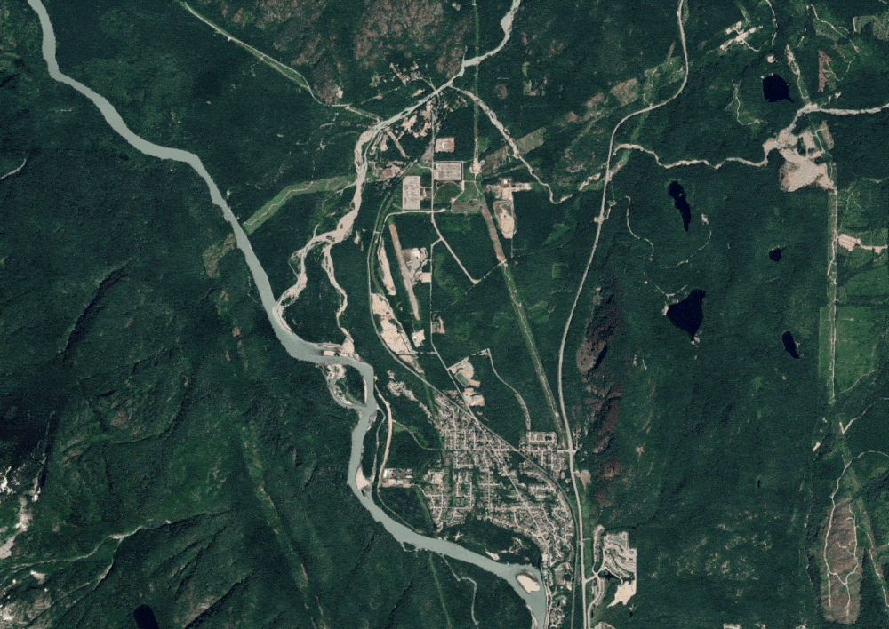
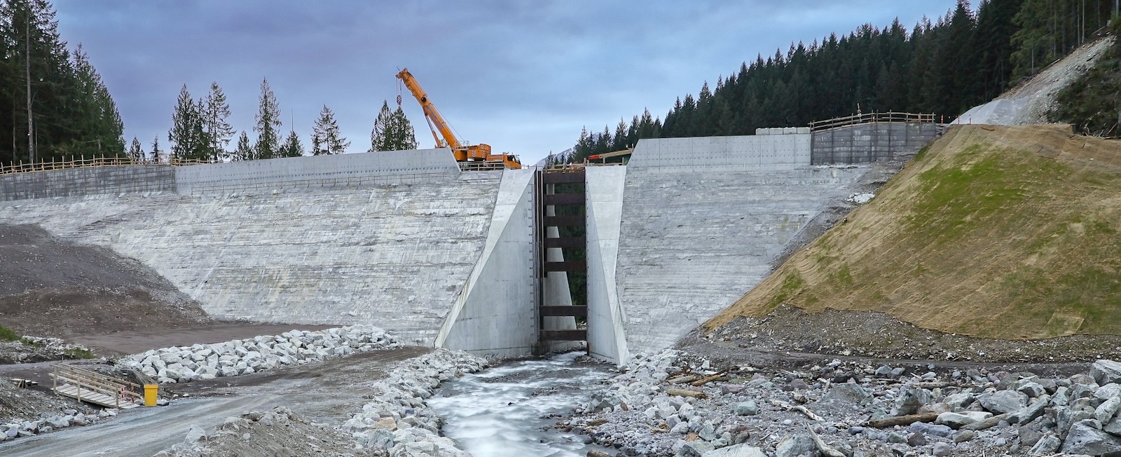
Standing eight storeys high and costing more than $100 million to build, a massive wall-like barrier stretches the length of two football fields across a narrow canyon shaped by the Cheekye River. Tucked next to a provincial park northeast of Squamish, the barrier is designed to stop massive and potentially deadly flows, while a six-metre-wide slot allows the river and small debris flows to pass through.
Still, some harbour concerns that it is not enough. Despite the barrier’s unprecedented size, one geoscientist who has studied the Cheekye debris flow for decades is concerned the structure may not mitigate the risks of the worst-case scenario.
A history of upheaval
Although geoscientists first discovered the historic landslide path in the 20th century, local Indigenous people of the Squamish Nation have known of the risk much longer. Long before settlers arrived, locals gave the volcano looming over the area the name Nch’ḵay̓, which means “strong rushing water” or “dirty place” in the Squamish language.
Volcanic rock has often tumbled from down the mountain and into the river that flows from its western flanks. The debris flows can accumulate energy as they descend and pick up mud, rocks, snow and trees along the way. Some flows have run all the way to the bottom of the valley. Over centuries, the deposits left behind have accumulated and created what is known as an alluvial fan.
The history of massive debris flows suggests the potential for similar events in the future. And the consequences of such an event today could be immense. Studies suggest a monumental slide could obliterate schools, a power substation, the highway, multiple Squamish Nation villages and some of the houses in a sprawling neighbourhood north of town.
For decades, the District of Squamish has managed the risks to its own lands through abstinence, by banning new development on its land in the line of fire.
In 2011 the Squamish Nation, which has long pushed for a solution, took a new approach. It purchased 467 hectares of land from the province, including parts of the upper Cheekye alluvial fan, where development had been previously banned. The nation then partnered with a development firm, Matthews West, and devised a plan to build almost 1,400 new homes. But first, the developer had to solve the upstream hazard.
After more than a decade of reports and three expert panels, the resulting partnership — a company called Sqomish Sea to Sky Developments — finalized a plan they hoped would make the fan safe for future development. But there’s no such thing as risk-free in Squamish.

‘Every hazard but tornadoes’
Located 60 kilometres north of Vancouver, Squamish is one of the fastest-growing communities in Canada. The town’s population has grown by two-thirds since 2010. By 2040, Squamish is expected to be home to at least 35,000 people — double its pre-Olympics population.
The demand for housing has pushed new developments up the valley’s slopes, onto dredged land along the waterfront and into the sky through densification. As of April, the average price of a detached home is $1.5 million. The home prices are some of the highest in the country despite the fact that many residents find it difficult to obtain adequate and affordable flood and hazard insurance.
The burgeoning valley town has nearly the full bingo card of potential natural disasters.
“I think we have every hazard here but tornadoes,” Squamish Mayor Armand Hurford said. The town is vulnerable to earthquakes, sea level rise, volcanic eruptions, wildfires, floods and debris flows — the term for a fast-moving, gravity-driven landslide. Much of the town sits on a flood plain, part of which is vulnerable to “liquefaction,” a process that turns solid ground into quicksand during shallow earthquakes.
For Hurford, who grew up in Squamish, the Cheekye River and everything upstream of it is an ever-present risk.
“The Cheekye in flood is quite a scary thing,” he said.
Living near the fan
On maps, the Cheekye alluvial fan covers more than 25 square kilometres, spanning from the river’s confluence with the Cheakamus River to the edge of the Brackendale neighbourhood in the south. Homes, roads, a railway and various other infrastructure sit on top of the fan. Though Squamish’s northern neighbourhoods have encroached on the fan, the municipality’s moratorium on building means that much of the upper fan remains forested.
The garbage dump findings, although significant, weren’t the first evidence locals had of former slides. In 1958, 100,000 cubic metres of debris surged down the valley and deposited sediment three metres deep.
Fifteen years later, a 1973 court case concerning a proposed development south of Whistler set a key precedent determining when building should be allowed in a proven landslide path. The judge ruled that the risk of a potentially catastrophic one-in-10,000-year event hitting the area was too high. With no attainable solutions, the ruling halted the new development.
The threshold for landslide protection is significantly higher than for floods because landslides are much less predictable. Those in the path of rising floodwaters can usually be warned ahead of time and people can be evacuated. That is one reason why the province requires dikes to withstand only a one-in-200-year event. Debris flows, on the other hand, can follow earthquakes, individual rain events or a prolonged period of wet weather, geoscientist Pierre Friele told The Tyee.
When a debris flow happens, Friele said, “it’s instantaneous.”
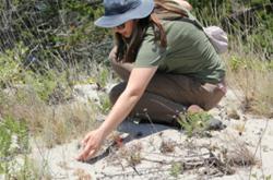
Friele has spent much of his career studying the Cheekye fan debris flow. Since 1999, he has dug more than 100 pits around the alluvial fan to backdate previous flows. His research showed evidence of an even larger landslide that hit the area with more than a million cubic metres of debris. He and his team dated that slide back 6,900 years. His work has earned him a reputation as a local expert, both in Squamish and in the geological community, and his work was quoted in many of the reports to inform the building of the barrier.
He has been closely following the fan’s development proposal as the developers and the municipality have grappled with how to move forward.
How much risk is too much?
The projected magnitude of a one-in-10,000-year event is itself uncertain. The first expert panel, which was commissioned by the District of Squamish in 2014, concluded that its “best estimate” of such an event projected a slide of nearly three million cubic metres — slightly larger than the garbage dump slide. But they also acknowledged the possibility of a larger worst-case-scenario slide with 5.5 million cubic metres of debris — roughly twice the volume of BC Place stadium.
Friele was surprised to find that the barrier’s final design, created after two subsequent panels focused on risk and design, won’t see the structure built to withstand that worst-case scenario. The barrier is now 10 metres shorter than initially promised a decade earlier and is intended to hold 2.4 million cubic metres of material and withstand the “best estimate” of a slide with 2.8 million cubic metres of debris.
Friele said he feels there has been a lack of transparency for the public about the downshifting of that risk threshold — a change that could cost taxpayers more in maintenance and leaves uncertainty about where the additional material would go. He told The Tyee that the estimated “upper limit” debris flow projection aimed to account for climate change and the escalating severity of the weather.
Without a barrier, a worst-case-scenario slide could have a massive impact on Squamish. Mud and debris would surge down to the valley at 40 kilometres an hour. A stampede of wet trees and rocks would likely destroy a Highway 99 bridge and cover the road in metres-high debris, cutting off vital arteries between communities. It would also halt more than $1 million a day in economic activity that the highway enables.
Though the debris would decelerate across the fan, it probably wouldn’t stop. A BC Hydro substation, two public schools, a subset of encroached neighbourhoods, and several Squamish Nation villages would be in its path. Matthias Jakob, a geologist and Cheekye fan expert, told the Squamish Chief in 2014 that a worst-case-scenario debris flow would likely reach the Cheakamus and even the Squamish River, where it could form a dam that could trigger a flood of much of Squamish to the south.
It remains unseen what the impact of that much material would be with the current barrier in place.
Karen Elliott, who served as a Squamish councillor during the beginning of deliberations and as mayor from 2018 to 2022 during the bulk of the deliberations, remembered the conversations about how to set the risk tolerance level. All new developments come with some risk attached. The question for council was to decide which level of risk is acceptable and which is not. They decided to accept no more than a 0.01 per cent chance of death in existing developments each year. In new developments, the district would tolerate even less risk — a maximum 0.001 per cent annual chance of death.
“There are some uncomfortable moments in that conversation.” Elliott told The Tyee. “For seven non-technical people sitting on council, it is a huge reality check.”
David Roulston, the district’s senior manager of infrastructure planning, told The Tyee in an email that the engineering firm hired to design the barrier determined that the 5.5 million cubic metres of flow carried only an eight per cent probability of occurring in a one-in-10,000-year event. Pointing to the detailed design report on the district website, Roulston said the barrier’s final design was guided by a risk management principle that calls for reducing risk as much as reasonably possible.
“Even though the consequences of [a 5.5-million-cubic-metre event] would be significant, the corresponding probability is so low that the risk is still reduced,” Roulston said.
Though there is a slim chance of that worst-case-scenario event, he said there is a larger chance that any number of smaller, yet still catastrophic, events could happen in any given year. Even a one-in-100-year event could have significant consequences that the barrier could prevent.
The goal, Roulston said, has been to reduce the chance that a landslide will turn fatal. The barrier can protect against those consequences, and related infrastructure damage. But the threat is ever present and will remain so long into the future.
“These risks exist in perpetuity,” Roulston said. “This is a hazard that will probably exist as long as there are people living in Squamish.”
A province of landslides
Alluvial fans like the Cheekye have always appealed to developers and homeowners alike. The relative flat aspect of such fans and their elevated position relative to the surrounding area made them a prime development target during the 20th century.
“The problem was that the hazards weren’t properly identified when a lot of these things were built,” said Brent Ward, a geology professor at Simon Fraser University and co-director of the Centre for Natural Hazards Research. “Nobody realized the risk.”
The last 20 years have provided ample evidence of destruction from landslides across B.C.
A 2010 Mount Meager slide caused more than $10 million in damage. In August 2018, a motorist was killed in one of 17 mudslides that hit Highway 99 near Cache Creek. The 2021 atmospheric river triggered hundreds of landslides, including one north of Pemberton that killed five people and a series of others that washed out major sections of the Coquihalla Highway, Highway 8 and Highway 1. And in 2024, a landslide about 40 minutes south of Squamish in Lions Bay killed two people in their home.
A 2025 study found that as climate change increases the frequency of events such as wildfires and atmospheric rivers, the risk of landslides will also increase.
“The Canadian government hasn’t done enough to protect communities from severe weather,” the Insurance Bureau of Canada wrote in a 2025 briefing. The bureau repeated its call for government to do more to adapt to climate change. Its recommendations included stiffening building codes and restricting new development in high-risk hazard areas.
Despite knowing the risks, municipalities don’t have the resources to pay for solutions on their own, Squamish Mayor Armand Hurford said. And he said senior levels of government haven’t been inclined to step in.
“The federal and provincial governments essentially failed to address this issue in the 40-plus years it’s been known,” Hurford said. If new development helps pay for building infrastructure, such as the Cheekye barrier, that can also protect the existing community, he sees it as a net positive.
“I think it’s quite remarkable that we’re able to get it to this point.... This wouldn’t have happened without the work of the Squamish Nation.”
The province, for its part, says it has managed risk to drivers through the area with “mitigation measures, such as rock netting, rock/soil catchment walls and debris catchment ditches, that have been in place over time.”
A new development road map
Matthews West president John Matthews is familiar with the challenges of building in high-hazard areas. In addition to the Cheekye project, Matthews West is also partnering with Squamish Nation on developing the Squamish oceanfront, land that had to be raised four metres to account for future sea-level rise.
“It’s tricky because there are lots of future risks” in Squamish, Matthews said. “The town is progressive enough to try and address a lot of that.”
Projects in areas with future risks can take a longer time to complete than those in less fraught areas, he said. They also require the developer to spend money up front just to figure out if the land can be developed.
“What makes this unique, and maybe us uniquely stupid or brilliant,” Matthews said, “is that we didn’t know what we didn’t know.”
Building an exceptionally large structure on Crown land to protect much of the town hadn’t been the only option on the table. Earlier in the process, the district had considered less expensive solutions like dikes and berms, but none of them could provide the same potential protection as an upstream barrier. Some solutions could have rerouted a debris flow and transferred risk to existing infrastructure. The upstream barrier was the only solution the district supported. Thus, the developer endeavoured to build it.
Through the process, Matthews said, there were many potential breaking points at which the project would no longer make financial sense, especially without a guarantee that the new land could be developed.
“But we are tackling every question along the way with the province, the district, ourselves and [the] review panel,” he said. “We’re all in a room together.”
Matthews said Sqomish Sea to Sky Developments, the joint company developing the Cheekye fan, can absorb the costs of building the barrier only because it can hedge the financing against its other project on the oceanfront.
Most people familiar with construction — even a renovation — will know that costs can balloon and unanticipated costs arise. The “groundbreaking” barrier was no exception.
During the two-year construction of the Cheekye barrier, three atmospheric rainfall events caused debris flows that washed out alluvial fill that had been protecting the concrete base of the barrier. Over the winter, parts of the base of the barrier also eroded. The damage forced the developer to redesign the base including the addition of granite stones. Estimated at $20 million at the project’s inception, the barrier has now cost more than $115 million.
Asked about Friele’s concerns that the barrier was not built to a higher threshold, Matthews said the barrier would still increase safety, even if it doesn’t stop all the potential material sliding downhill.
“If that event occurred without the barrier, you’d have massive, massive loss of life all throughout Brackendale. So, this would effectively slow all that material down,” Matthews said. “But you’d have a lot of cleanup to do after.”
Next steps
This summer, the municipality will take ownership of the barrier, with a two-year warranty. In the future, it will be responsible for annual maintenance and operations, which will include routine inspections and maintenance to the access roads and structure. The district estimates the barrier will cost taxpayers $1.4 million a year. Of that, a little more than half will go to maintenance, with the rest of the money put into reserves to pay for future capital expenditures and to clear debris left by larger flows.
In 2024, as construction began, the province agreed to backstop the district if a landslide occurs before Squamish sets aside enough money to pay for any necessary cleanup and repairs.
The operations and maintenance funding will be split 50-50 between owners in new development on the fan and all Squamish taxpayers. Sharing costs across neighbourhoods is typical in Squamish, Roulston said. The municipality’s tax base already pays to mitigate other hazards to different neighbourhoods, including $4 million a year for the next two decades to upgrade the dikes on multiple rivers, and $18 million on a section of sea dike.
“This is maybe the first of its kind that has such a unique funding arrangement and such a large scale of development and hazard mitigation,” Roulston said, “but maybe this is going to be a blueprint for future development in B.C., and other areas in Canada.”
*Story updated on May 22 at 11:30 a.m. to correct the fact that Squamish Nation purchased land from the province, not the district, and to clarify the location of the barrier. ![]()
Read more: Environment, Urban Planning


Tyee Commenting Guidelines
Please note that email notifications for replies are not currently working due to a software issue which may be resolved in a future update.
Comments that violate guidelines risk being deleted, and violations may result in a temporary or permanent user ban. Maintain the spirit of good conversation to stay in the discussion and be patient with moderators. Comments are reviewed regularly but not in real time.
Do:
Do not: