


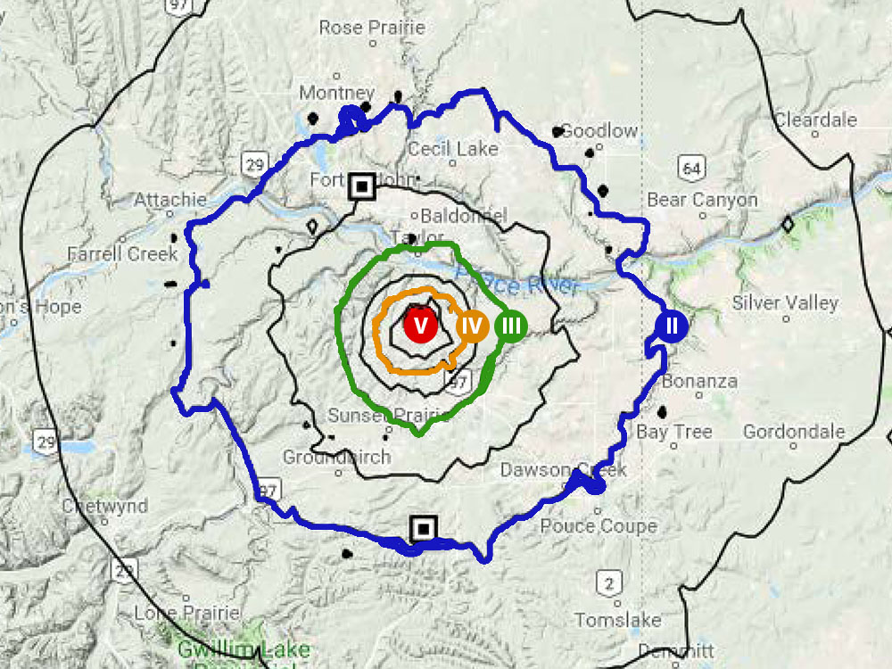
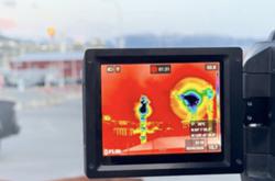
The computer-generated map above tells a story about ground shaking.
It tells the story of a magnitude 4.5 earthquake felt by hundreds of people in the northeastern B.C. communities of Fort St. John, Taylor, Chetwynd and Dawson Creek. Experts say the tremor was likely caused by the oil and gas industry.
The “shake map” shows the intensity of ground motions generated by the tremor and what people likely felt, based on publicly available ground-motion recorders.
Such maps are automatically generated by a computer after it receives what researchers call “near-real-time-data” collected by local seismic stations.
They can be created within 10 minutes of a seismic event and help researchers and communities evaluate post-earthquake response and recovery, as well as help scientific research and disaster planning.
Although the U.S. Geological Survey makes shake maps for every earthquake, they remain a novelty in Canada.
The illustration above is a prototype.
But Western Canadians will soon have access to such maps thanks, in part, to Canada’s Geological Survey and Gail Atkinson, a professor at the University of Western Ontario and one of the nation’s top experts on hazards posed by earthquakes.
Together with Karen Assatourians, Atkinson has developed a shake-mapping system that should be accessible to the public next year.
A shake map, says Atkinson, is based on the Modified Mercalli Intensity Scale. Developed in 1931, it denotes ground motion intensity with a set of 12 Roman numerals.
A level one (I) quake is generally not felt, but two (II) or three (III) may be weakly felt. Some people may even experience nausea and dizziness with this level of ground shaking.
At level four (IV) people may feel strong shaking, and at level five (V) they “really feel it,” says Atkinson.
Level six (VI) is the damage threshold, with effects such as cracked chimneys, while level seven (VII) produces “very strong” shaking combined with moderate damage. An intensity of eight (VIII) or nine (IX) corresponds to violent shaking with increasingly severe damage.
‘Like a tank crashed into our house’
On the map above, the red dot marks the epicentre of the quake, and the concentric circles emanating out like waves depict ground motions as they travel further away from the source and degrade.
The November quake, on which this map was based, was felt as far away as 100 kilometres.
Anyone standing in the first circle enclosing the red dot, where the shaking could have surpassed the damage threshold of level five or possibly level six, “would have felt the earthquake really strongly,” explains Atkinson. This area has a diameter of about five kilometres.
“If there had been critical infrastructure in that circle, you might had seen some damage,” says Atkinson. Trees and bushes would have shaken, too.
An intensity of five or six can crack windows, break dishes and overturn furniture.
Anyone or anything within the black line with a ground motion rating of IV, stretching over a 20 to 25 kilometre diameter, would have felt the event extensively.
Next comes the black line that runs through the community of Taylor at its north boundary and Sunset Prairie on the south.
“Just about everyone in that area would have felt the event,” says Atkinson.
Taylor resident John Bourgeois, for example, told the Vancouver Sun that the quake “felt like a tank crashed into our house.”
He thought the furnace or a local gas plant had blown up.
In Farmington, Liam Strasky, a farmer and carpenter, also felt ground motions. “All of a sudden we heard a bang and the house shook violently for five to six seconds,” said Strasky. “We could tell it was a seismic event.”
The next contour encompasses the city of Fort St. John where, explains Atkinson, “some would have felt it and some not.”
Anyone residing in a river valley with soft sediment or living in a tall building would be more likely to have felt the quake, she adds.
One Fort St. John mother tweeted that she “just felt our entire apartment building shake like the top floor was gonna fall off.”
The last contour, which runs through Dawson Creek, shows ground motion intensity weakening to level two.
“You probably had some people feeling the tremor here too,” says Atkinson.
Ground motion, the measure of an earthquake’s shaking intensity, matters as much as a tremor’s magnitude, which quantifies the amount of energy released by a quake, says Atkinson.
That’s because industry made quakes, such as those triggered by hydraulic fracturing or wastewater disposal, pose a different hazard than natural quakes due to their shallowness.
For example, shallow quakes with magnitudes as low as 3.5 to 4.0 can possibly damage buildings if they are close to the source due to stronger ground shaking.
The B.C. Oil and Gas Commission is now investigating the cause of the quake, which it believes is linked to fracking or wastewater disposal operations of Canadian Natural Resources Ltd.
The Tyee recently reported that two of the company’s wastewater wells triggered scores of earthquakes three years ago.
A 2017 report on hundreds of industry-triggered quakes in northeastern B.C. noted that ground motions remain a big concern.
“Although most induced events in northeast British Columbia have small magnitudes (< 3), shallow depth of these events can be a controlling factor in the observation of large ground motion amplitudes that can be concerning to the public and infrastructures such as the BC Hydro Site C project,” it said. ![]()
Read more: Energy, Environment


Tyee Commenting Guidelines
Comments that violate guidelines risk being deleted, and violations may result in a temporary or permanent user ban. Maintain the spirit of good conversation to stay in the discussion.
*Please note The Tyee is not a forum for spreading misinformation about COVID-19, denying its existence or minimizing its risk to public health.
Do:
Do not: