


 SHARE:
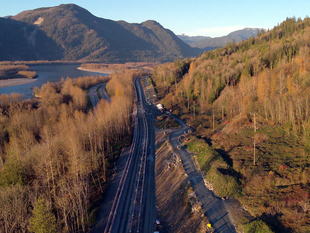
It’s one thing to build a pipeline on paper. It’s another to construct it through one of the world’s most crowded and geographically difficult transportation corridors, as Trans Mountain Pipeline Co. painfully discovered.
By 2022, the company had built out most of the Trans Mountain expansion project, then watched billions of dollars and nearly two years evaporate as it struggled to advance through the Fraser Valley’s hard rock and narrow walls.
Now a new West Coast Oil Pipeline, proposed and primarily driven by the Alberta government, is well into the planning stages. Alberta pegs the cost at no more than $43.7 billion, and Ottawa is just six weeks away from deciding whether to fast-track the project.
But Alberta has yet to decide how it will navigate the narrow stretch of valley that turned the Trans Mountain pipeline into a financial boondoggle.
Alberta holds out the possibility that it can avoid Trans Mountain’s geologic pitfalls by following a different route. But a close look reveals the alternative holds well-established challenges and must tackle problematic geology like what fouled Trans Mountain’s finances.
Trying to avoid the hole problem
In June 2022, Trans Mountain began boring a 2.3-kilometre hole through a mountainside east of Chilliwack, on the southern edge of the Fraser Valley.
The area is one of several stretches where the valley narrows and the Fraser River abuts the valley’s mountains, leaving barely enough room for Highway 1 and the Canadian National Railway line to squeeze between water and near-vertical rock faces.
Trans Mountain hoped to create a tunnel four feet wide that would allow it to install a three-foot-wide pipeline. Sixteen months later, in October 2023, the company was still drilling. It had created a sizable hole but needed to widen it and had no idea just how long it would take to get to its target. So Trans Mountain improvised, asking and eventually receiving permission to shrink the hole’s width to 42 inches to accommodate a 30-inch-wide pipeline, slightly narrower than standard for the project.
The pipe finally made it through the mountain in April 2024, nearly two years after drilling commenced.
This time around, Alberta is seeking to avoid the stubborn rock Trans Mountain previously encountered by plotting a route on the northern, opposite side of the Fraser Valley.
The proposal, however, is so vague as to raise questions about how much research Alberta actually has done and whether its new route is feasible without breaking the bank.
Where is British Columbia’s government in all this? Watching and waiting. While B.C.’s opinion factored in to the determination that a pipeline should end with a southern terminus, the province has not yet got a say into how the pipeline will get to the south coast, though Canada’s Major Projects Office told The Tyee consultations will take place as the route is finalized.
The Fraser Valley narrows, no getting around it
The Fraser Valley lies along a northeast-southwest axis. Although the flat, corn-friendly landscapes of Chilliwack and Abbotsford might define the perception of the valley as a broad agricultural hub, toward its eastern end, the walls close in.
North of Chilliwack, the valley’s topographic profile shape begins to resemble that of a hard taco shell, with steep, almost vertical mountainsides descending to a narrow, flat bottom.
Running through this tight chute is perhaps the densest concentration of transportation and energy infrastructure in Canada. Between the river and the mountains, two rail lines, highways and pipelines — one on each side of the river — compete for shards of land. All were originally constructed more than 60 years ago, when standards, regulations and expectations were much looser.
Modern technical and safety requirements make the path chosen through the Fraser Valley particularly high stakes. Here is where blown timelines can balloon costs. Let’s break down the two options offered in the proposal.
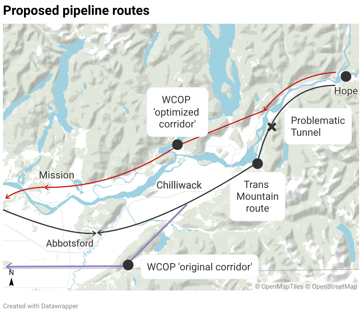
Option 1 is an ‘original corridor’ that’s
different from the original
For nearly 1,000 kilometres, Alberta’s proposed corridor “generally follows” Trans Mountain’s existing line, according to the province’s July submission to the federal Major Projects Office. But as it passes west through the town of Hope at the far eastern end of the Fraser Valley, Alberta says it will follow one of two paths — an “optimized corridor” on the north side of the river or an “original corridor” on the south side.
The latter appears to be Alberta’s fall-back option. Its name inaccurately suggests the pipeline would continue following the Trans Mountain’s path to the Pacific. But whereas the Trans Mountain route takes a relatively direct route through intensely farmed areas south of the Fraser Valley, Alberta’s primary corridor would veer farther south, cut through the Cultus Lake area and run parallel to the Canada-U.S. border to a new marine terminal in Delta.
The route would still have to navigate the same tricky terrain west of Hope that bedevilled Trans Mountain just a few years ago, but with less room to operate because of the space occupied by the existing pipeline and Highway 1. It would then encounter new potential obstacles south of Chilliwack and near Cultus Lake, one of the Lower Mainland’s favourite local tourist destinations. The submission says the corridor travels "through Cultus Lake." The western side of the lake itself is a provincial park. The eastern side is a steep mountainside.
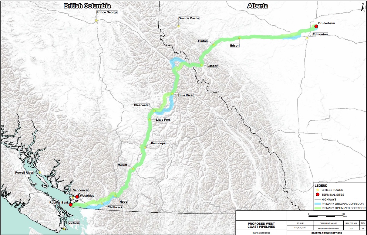
Alberta’s submission says 77 per cent of the “original corridor” would be located within 300 metres of the Trans Mountain pipeline. That leaves 286 kilometres of pipeline to build through land well away from the existing pipeline.
Option 2 is an ‘optimized corridor’ vague in the details
Of the two paths presented in the proposal, Alberta seems to prefer what it calls an “optimized corridor” on the north side of the Fraser River.
Although Alberta wrote in its submission that the optimized route would deviate from the Trans Mountain corridor “in a few sections,” its submission suggests the need for considerable rerouting — and that carries some big implications.
According to the submission, only half of the optimized 1,211-kilometre route would be within 300 metres of the Trans Mountain pipeline. While Alberta says much of the route would be built through already “disturbed land,” more than 200 kilometres of pipeline would need to be built through presumably undisturbed areas.
The optimized route would deviate from the Trans Mountain line west of Jasper, between Clearwater and Blue River, and west of Hope, according to a map contained within the submission.
The submission describes the Fraser Valley corridor only in extremely broad terms.
In the Fraser Valley, Alberta says, the route would run “from west of Hope to Mission, then south through Langley.” It says the corridor runs on the north side of Highway 7 “past Harrison Hot Springs, through Harrison Mills and remains generally north of the small farming communities of Lake Errock, Deroche, Dewdney and Hatzic.”
It says that north of Mission the pipeline would cross the Fraser into Langley, travel southwest to Highway 99 and then swing immediately west to Roberts Bank in Delta.
With that, Alberta’s 89-page submission concludes its description of how it will get a pipeline through the Fraser Valley’s many obstacles.
The ‘optimized’ route includes some crowded challenges
There are a few things worth unpacking in Alberta’s description of the Fraser Valley portion of its “optimized” route.
The description of the north-Fraser route between Hope and Mission suggests Alberta wants to build its pipeline on, through or along mountainsides either where roads and other energy infrastructure generally don’t exist, or in places where existing infrastructure already occupies the little available space.
Alberta officials did not respond to The Tyee’s inquiries, and officials with the federal government’s Major Projects Office said specifics are still being hammered out.
But Alberta’s proposal indicates the pipeline will cross to the north side of the Fraser River near Hope. It’s not clear exactly where, however. A gas pipeline operated by Westcoast Energy is already elevated over the Fraser just to the west of town. The location of that crossing is carefully plotted to allow it to avoid large rock outcroppings on either side of the river.
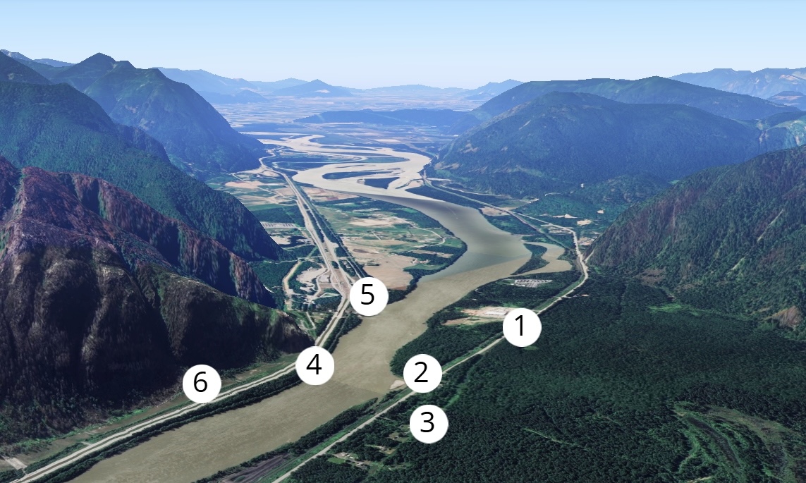
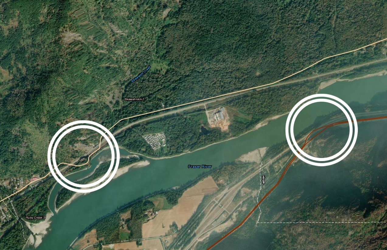
There will be no avoiding, however, a significant narrowing of the valley about 10 kilometres west of Hope. Here, the valley is barely a kilometre wide, with the Fraser occupying much of that space. Much of the remaining land is bisected by two highways, two pipelines and two railways.
Existing infrastructure sits cheek to cheek on both sides of this part of the river. On the south side of the Fraser, the lack of space is significant, and previously necessitated tunnelling by Trans Mountain. This was a different tunnel altogether than the one in which the company ran into its major problems.
On the north side, Westcoast Energy’s gas pipeline crosses beneath the rail line and the highway twice in the span of just a couple of hundred metres. The mountainside there is extremely unstable, with massive boulders illustrating the frequency of rock slides in the area.
To the west of this tricky stretch, were the West Coast Oil Pipeline to press on, carrying up to one million barrels of crude per day, the terrain does not become much friendlier.
The existing Westcoast Energy pipeline deviates away from the Fraser River, in this stretch, travelling up a mountainside and traversing a high valley also crossed by a large BC Hydro transmission line. On both sides of the valley, from Hope to Chilliwack, landslides and ground movements are increasingly common and have repeatedly closed highways over the last decade.
Nothing about such risks is mentioned in the proposal, nor does the submission dwell on the area’s massive landslide risk, as demonstrated during the 2021 atmospheric river.
The pipeline might avoid the site of a particularly huge slide by following the BC Hydro line briefly into the mountains and west, just south of the resort community of Harrison Hot Springs.
But from there another set of considerable obstacles awaits.
This is where two mountains stubbornly stand in the way
South of Harrison Hot Springs, at Agassiz, the Westcoast pipeline crosses the river toward Chilliwack and the flatter Fraser Valley prairies. Alberta doesn’t plan to go that way, however. Neither can it follow the east-west BC Hydro line, which swings north, high into the mountains.
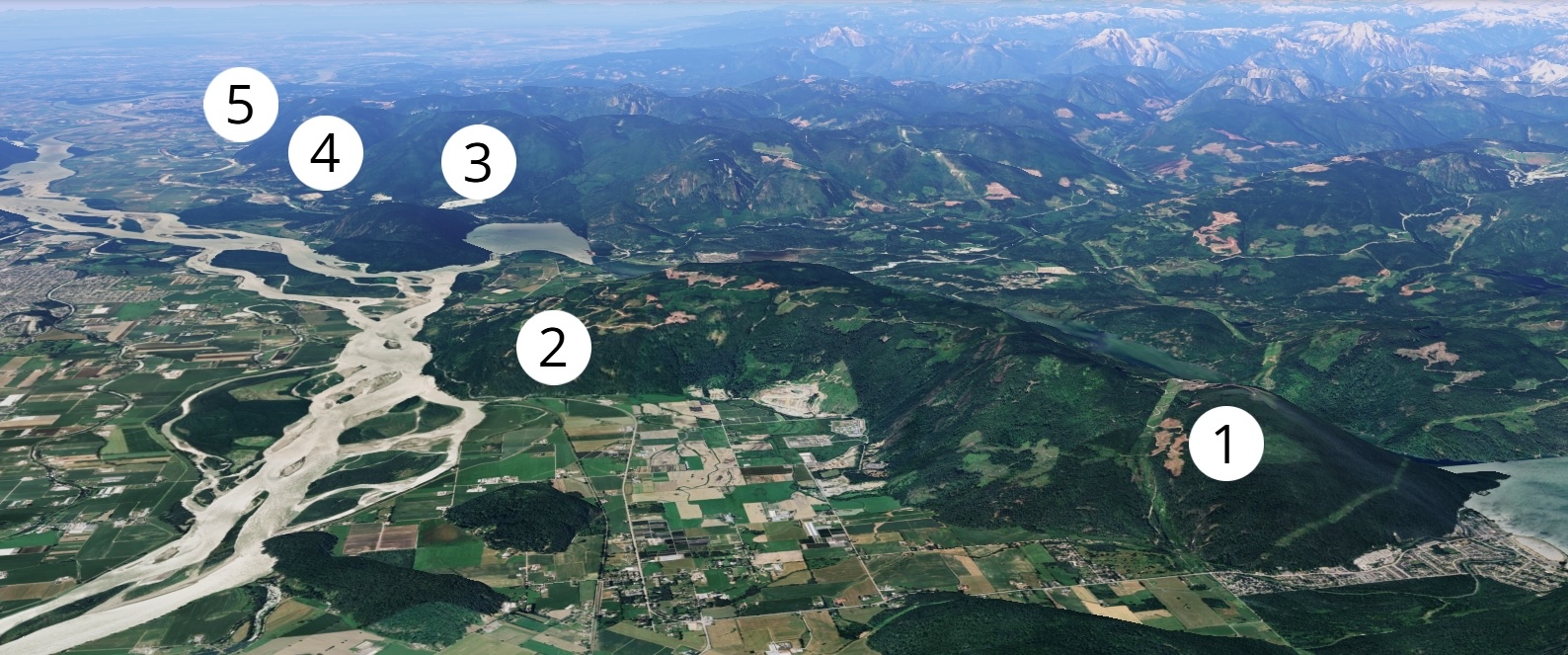
Instead, the “optimized” route proposed for Alberta’s pipeline will continue to travel roughly parallel to Highway 7. But getting a pipeline from Harrison Hot Springs to Mission will require going over, or through, one of two adjoining mountains, Mount Agassiz and Mount Woodside. The latter, which rises out of the Fraser River, is steep enough to be one of British Columbia’s most popular hang-gliding takeoff locations.
There are two places between Hope and Vancouver where a highway climbs over, rather than going around, a mountainous obstacle. The first is alongside Trans Mountain’s two-year tunnel. The other is at Mount Woodside.
West of these mountains, the province’s submission says, the pipeline would stay “generally” north of the small communities that line Highway 7. But those tiny farming communities — Lake Errock, Deroche, Dewdney — sit at the southern base of steep mountains. Skirting them would require dealing either with property owners or with unknown mountainsides where east-west infrastructure has not yet been developed.
The orientation of the mountains poses a distinct challenge. Along Alberta’s “optimized” route there are other corridors in B.C., near Jasper and Clearwater, that travel through river valleys parallel to their existing routes. But there are no east-west valleys parallel to the Fraser Valley. The BC Hydro line cuts perpendicularly across high mountain drainages, a luxury allowed by the fact that power lines can hang lines between distant towers. Pipelines, on the other hand, are rooted to and confined by the land under which they travel.
Why one expert asks, ‘Do they know what they’re doing?’
In general, the farther west the pipeline gets, the more the challenges become human, rather than geological. Trans Mountain’s recent past suggests those obstacles, which will involve negotiating with private property owners, may be resolvable by paying landowners and the area’s First Nations. But Alberta’s submission regarding its path through Mission raises significant questions both about its local route and about the thoroughness of its planning work.
That document says it will avoid “the urban area north of Mission.” But there is no urban area north of the modestly sized Fraser Valley city. There are rural neighbourhoods north of the city’s core (though those areas are themselves located in the municipality), but Mission is the only urban area.
Drew Brayshaw, a Fraser Valley hydrologist and geoscientist, says the same rock formations that recently bedevilled Trans Mountain on the south side of the valley also proliferate north of the river. The mountains, which were formed by the collision of plates millennia ago, provide numerous obstacles over a relatively short stretch of land.
“You’re not dealing with one thing all the way,” he says. “You’re dealing with a whole bunch of different little things.”
To Brayshaw, the submission’s lack of information and its descriptions suggest a route developed “by somebody who has never been here looking [at]... Google Maps with the terrain turned off.”
The submission suggests the original corridor route would encounter the recreation area of “Slesse.” That is the name of a distant mountain and a rural Chilliwack River Valley neighbourhood, but both are seemingly well off the suggested route.
“It really seems to me like they're picking names off; somebody in Alberta is circling names on a map and making that their submission,” Brayshaw said.
The province of Alberta did not return The Tyee’s emails seeking more information on the proposed route. A spokesperson for Canada’s Major Projects Office wrote: “The proposed corridor has not yet been finalized and will continue to be developed through technical review, engagement with stakeholders, and consultations with potentially impacted Indigenous communities.”
It hopes to make a decision by Oct. 1 on whether to list the pipeline as a “national interest project” that would fast-track its construction. ![[Tyee]](/design-article.thetyee.ca/ui/img/yellowblob.png)






Tyee Commenting Guidelines
Please note that email notifications for replies are not currently working due to a software issue which may be resolved in a future update.
Comments that violate guidelines risk being deleted, and violations may result in a temporary or permanent user ban. Maintain the spirit of good conversation to stay in the discussion and be patient with moderators. Comments are reviewed regularly but not in real time.
Do:
Do not: