


 SHARE:

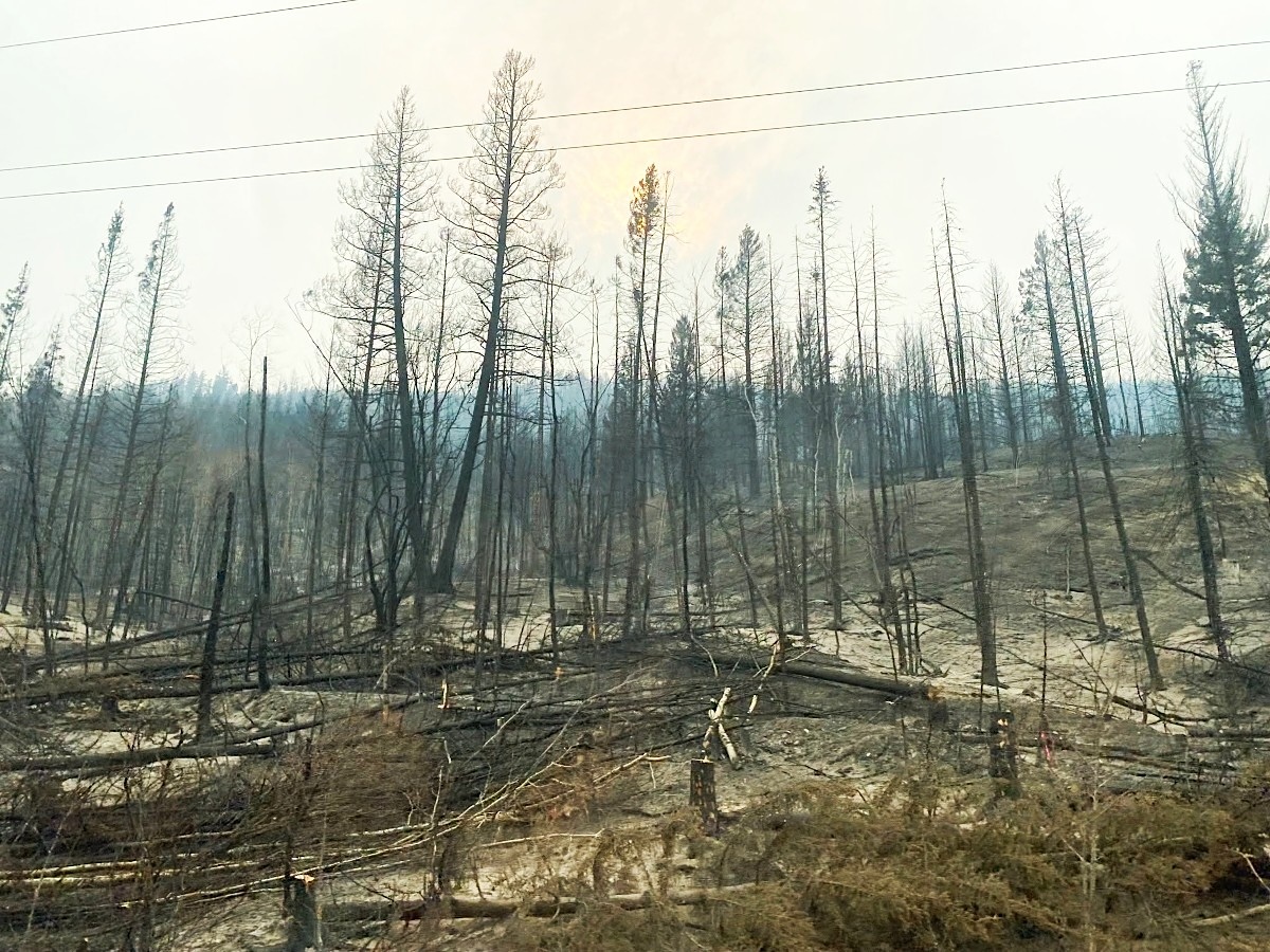
First came the flames. Now, floods and landslides are occurring across the charred landscape surrounding Clinton, in B.C.’s central Interior, and a new report warns more are to come.
Over the summer, the Pear Lake wildfire grew to be one of B.C.’s largest recorded blazes, burning 160,000 hectares and more than 100 structures.
Rebuilding and cleanup work has begun, and officials are now rapidly assessing how much the Pear Lake fire has increased the risk of future flood and landslide events. As they do so, the legacy of another recent central Interior fire illustrates why experts are so concerned.
Lessons from the Elephant Hill fire
Wildfire is a natural phenomenon that can be good for a landscape’s ecological health. Fires of low and moderate intensity can clear out dead wood, open up forests for ungulates and trigger the growth of young grass and trees. They can also reduce the risk of future blazes.
Last year’s Pear Lake fire, however, didn’t behave naturally. The blaze, which followed severe drought and was fed by climate-change-stoked temperatures, raged through thick, homogeneous forests, burning with fiery intensity across a massive area, and consuming almost all the available vegetation in many places.
Aednik Kleeband, the chair of the Clinton and District Outdoor Sportsman Association, said the fire zone is a bleak and desolate landscape.
“It’s incredibly sobering how bad it burned up there,” she told The Tyee. Her organization has been cleaning up the remnants of seven ski huts that burned over the summer, but the trails that wind through the forest are now surrounded by blackened trees and little greenery.
“It’s just devastation. It’s just very, very depressing,” she said.
With few stands of living forest in the area, Kleeband said she is worried about how long it will take for it to recover. She hopes that permits will allow tree clearing and replanting in the flatter, marshier plateau areas.
“There’s some question of what seed bank remains,” she said.
Normally trees, shrubs and grasses combine to slow the rate at which rain and snowmelt enter valley streams, creeks and rivers. The roots of grasses, trees and other plants also help prevent the erosion of soil and sediment.
The intensity of Pear Lake’s flames stripped the land of much of its natural protections and has left it vulnerable to floods and slides in the years to come, according to a newly released Ministry of Forests preliminary report.
The report was hastily completed this fall to set the stage for a more detailed investigation of the dozens of risks it identified.
Locals will already broadly know the danger is not hypothetical, even if the specific threats are still being catalogued.
Nine years ago, in 2017, the massive Elephant Hill fire burned nearly 200,000 hectares of land south of Clinton. In the year following that fire, more than 80 landslides were recorded, according to the report. Thirteen events affected a stretch of road in an area that reburned last year.
Those slides came with real consequences.
Following the 2017 fire, the Bonaparte River repeatedly hit new peaks, displaying uncharacteristic behaviour attributed to the recent fire. The high water triggered repeated warnings. In the hills to the west of Cache Creek, a mudslide swept down a hillside and across Highway 99, enveloping a car and killing its occupant. Floods tore through Cache Creek and other Interior communities again in 2023.
“The reality is that we’re seeing more and more of this, cascading emergencies,” said Kevin Skrepnek, the Thompson-Nicola Regional District’s manager of community and emergency services. “Folks in this area are acutely aware of the hazards that happen afterward.”
New fire, new danger
The Pear Lake blaze is expected to produce similar threats.
The new report documents dozens of potential landslide and flood locations, broadly evaluating the scale of threat in various areas based first on the likelihood of a landslide or flood event, and then on the chance that it will affect humans, their property or the infrastructure they use. The report will be followed by a more detailed analysis of individual locations.
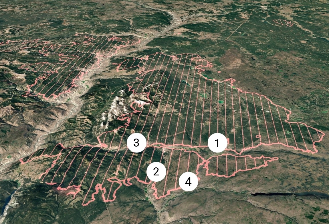
Many of the high-risk locations identified by the report are along Highway 97 and concentrated just south of Clinton. Eight years ago, the east side of the valley experienced debris flows following the Elephant Hill blaze. This year, the west side of the valley burned and could trigger slides that could affect Highway 97, the report warns.
Pavilion-Clinton Road, a forest road connecting Clinton to ranchlands to its west, is listed as being at “very high” risk. The southern part of the road, which travels through ranchlands and forests, has been closed to traffic since the fire and has yet to reopen.
The report also highlights continuing danger to BC Hydro’s Kelly Lake substation, one of the Interior’s key electricity routing points. The fire burned through the area, destroying about 200 power poles and “several kilometres” of electrical line, a BC Hydro spokesperson wrote in an email. Hundreds of workers were involved in the effort to repair infrastructure. In the email, the spokesperson wrote that the Crown corporation is reviewing the new report “and will assess whether further measures are required to protect our assets.”
The danger will eventually ease as nature recovers, but it will take time; Skrepnek said the first and second years after a fire tend to have the highest risk of debris slides and floods. He said the regional district is focused on delivering information to residents and is awaiting the full report, which is expected in December. Emergency officials will also be preparing for potential closures to key transportation corridors over the coming years.
The post-fire period can also pose challenges for local human infrastructure such as culverts and ditches that are designed for different landscapes.
“An event like this is going to put a bit of a magnifying glass on that infrastructure,” Skrepnek said.
Clinton itself could be relatively protected by the broad valleys with wetlands and meadows that typically slow the progression of heavy flows. But potential danger lurks just above the town, where an unused Canadian National Railway line crosses Clinton Creek.
Water from the tiny creek normally passes through a 70-centimetre-wide culvert beneath the rail line. But that culvert could prove insufficient to handle increased post-fire flows, the report says. Water could build up behind the rail line before the resulting pressure blasts through the blockage, creating an “outburst” flood. That, the report says, could affect homes and infrastructure in Clinton that survived the fire untouched.
Immediately following the Pear Lake fire, returning residents were placed on evacuation alert because of the dangers posed by the possibility of flooding due to the narrow culvert. The Village of Clinton is independently evaluating the danger, according to the report.
Kleeband’s home is one of those in the path of a potential outburst flood.
“We’re literally in the path,” she said. “It will come down Clinton Station Road, pop over that cliff, come down to our neighbours, then shoot three or four houses into us.”
Kleeband is trying to be optimistic, hoping that drier weather also will reduce the frequency of large rain events. But she is also worried that CN won’t move quickly to fully resolve the issue before a large storm creates challenges. In 2025, the rail company notified the province that it intended to abandon the line, which runs between Squamish and 100 Mile House. Local communities and the province have been working to come up with a plan to preserve the corridor, and CN remains in charge, for now.
CN did not immediately respond to The Tyee’s request for comment. 
Read more: Environment






Tyee Commenting Guidelines
Please note that email notifications for replies are not currently working due to a software issue which may be resolved in a future update.
Comments that violate guidelines risk being deleted, and violations may result in a temporary or permanent user ban. Maintain the spirit of good conversation to stay in the discussion and be patient with moderators. Comments are reviewed regularly but not in real time.
Do:
Do not: