


 SHARE:
U.S. officials have identified a treatment for an American river’s chronic flooding of a key Fraser Valley transportation corridor and agricultural hub. The cure, though, is much more elusive.
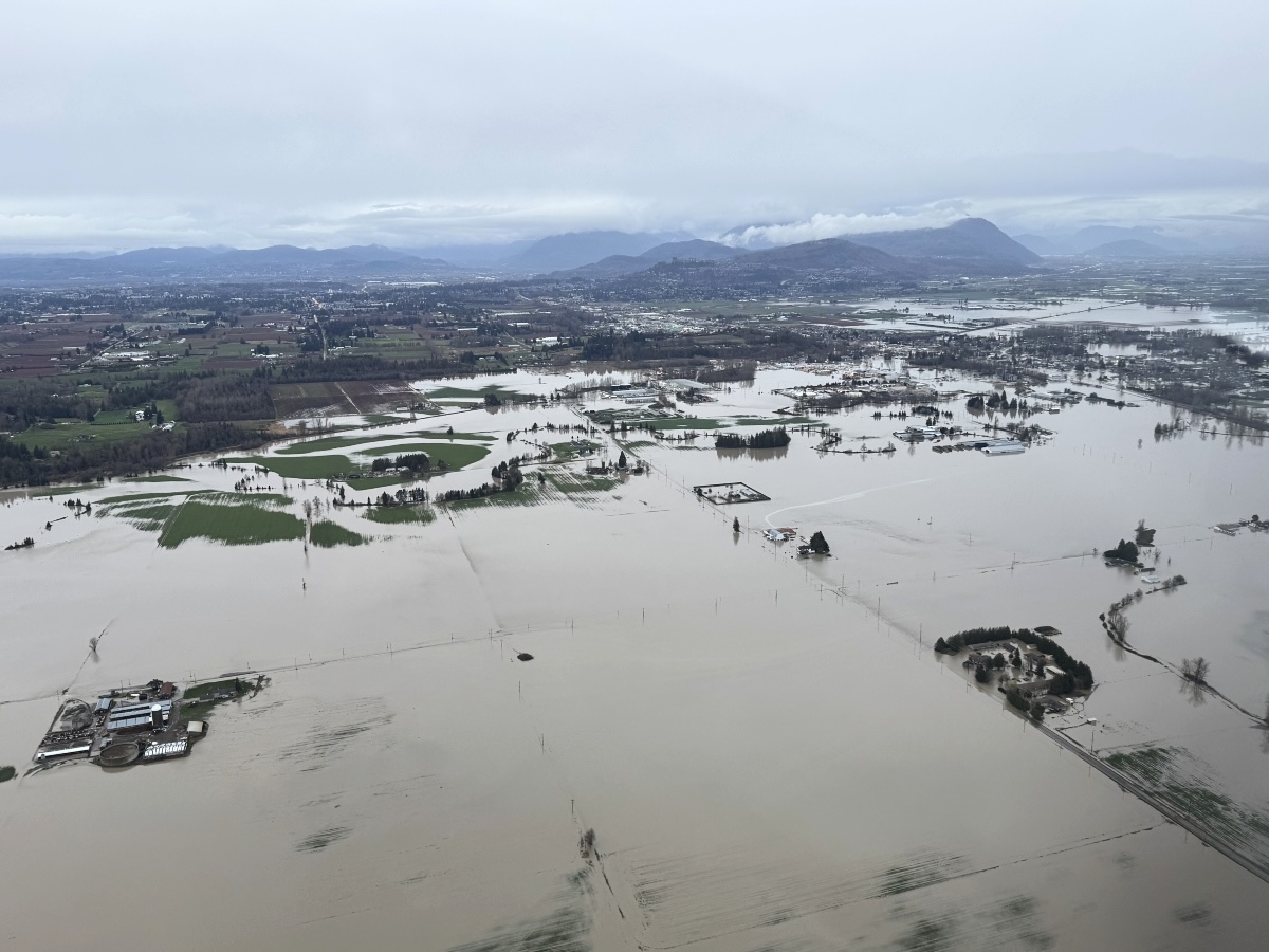
Over the last five years, the Nooksack River has twice breached its banks, crossed into the Fraser River’s watershed and flooded Abbotsford’s Sumas Prairie. The 2021 flood was one of the most expensive disasters in Canadian history. The second flood, last December, forced thousands of people from their homes and closed Highway 1 for three days.
After years of study and modelling, scientists and officials have now confirmed that the floods are not just bad luck, but the result of sediment accumulation aggravated by a human-caused bottleneck. Climate change is also likely increasing the flood risk.
The sediment challenges have significantly increased the flood risk over the last two decades and appear to be a key factor in the quantity of water that flowed into Canada in 2021 and 2025.
In a series of technical documents, U.S. officials have assembled a suite of potential changes that could reduce today’s flood risk. But they’re primarily aimed at shifting the river’s Canadian flood risk back to what it was two decades ago.
For Canadians and their elected leaders, the changes suggest some potential relief — but they’re not a solution, and future floods will happen sooner or later.

The challenge
The Nooksack presents both political and hydrological dilemmas. The river’s normal course takes it entirely through northern Washington, leaving its management entirely in the hands of U.S. officials.
But when atmospheric rivers cause it to rise, a quirk of geography allows its floodwaters to spill into the Fraser River’s basin and cause immense damage in Sumas Prairie, a highly intensive farming region that produces a massive chunk of B.C.’s homegrown food. The narrow prairie is also bisected by railways, Highway 1, a major BC Hydro transmission line and multiple pipelines.
Though the Nooksack’s waters have crossed into Canada multiple times over the last century, the threat seems to be increasing. The Nooksack spills into the Fraser River’s basin just south of the town of Everson, 10 kilometres south of the U.S.-Canada border. The recent floods have also caused significant damage in Everson, the border community of Sumas and farming outposts between the two areas.
For decades, discussions about reducing the Nooksack’s northbound flood risk have been stymied by the fact that any significant change to reduce the amount of water headed to Canada would aggravate flooding downriver within the United States through more populated centres, such as Lynden and Ferndale.
But the 2021 flood, and a series of analyses and modelling exercises completed by U.S. officials and hydrologists, have now led Whatcom County officials to declare that more needs to be done to reduce the proportion of water that floods north.
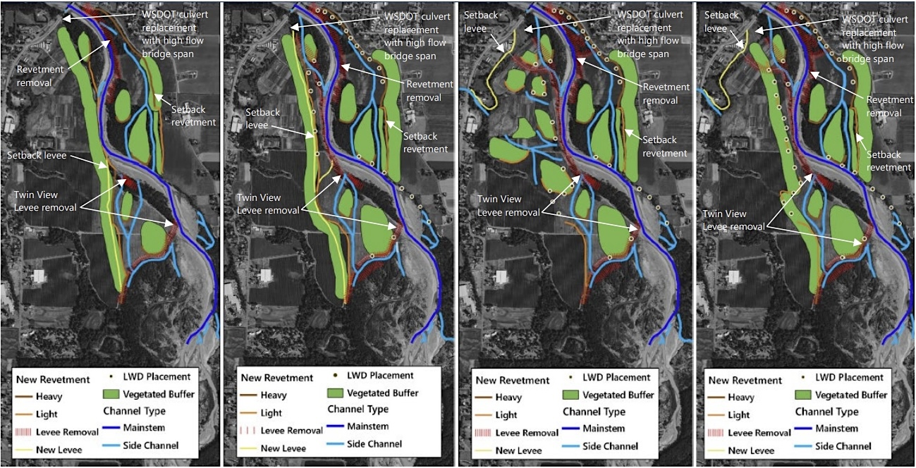
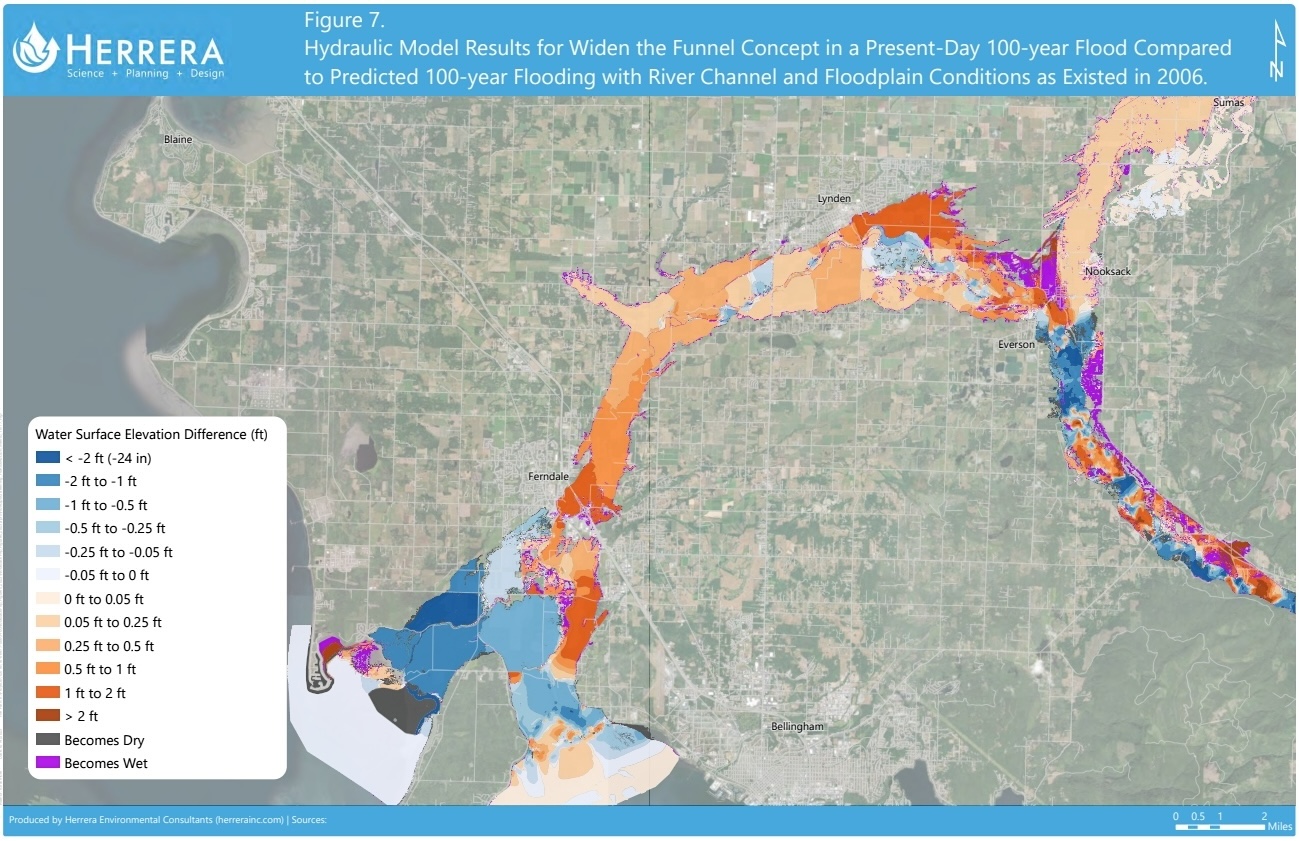
The largest mitigation concept is called “Widen the Funnel,” which would provide more room for the river south of the key Everson bottleneck. The plan would see dikes moved away from the river in conjunction with work that could allow more water to pass beneath or around the Everson bridge. Giving the river more room to accommodate higher waters, and expanding the bridge-created bottleneck, could reduce the height of floodwaters at the Canadian border by as much as a foot in the event of a significant modern-day flood, modelling suggests.
But the flood risk both in Canada and downriver in the United States would still remain higher than it was in 2006.
The concept could also aggravate flooding in the United States, meaning that to proceed, officials need to get federal funding to both widen the funnel and deal with the downstream consequences of doing so.
The sediment and the bridge
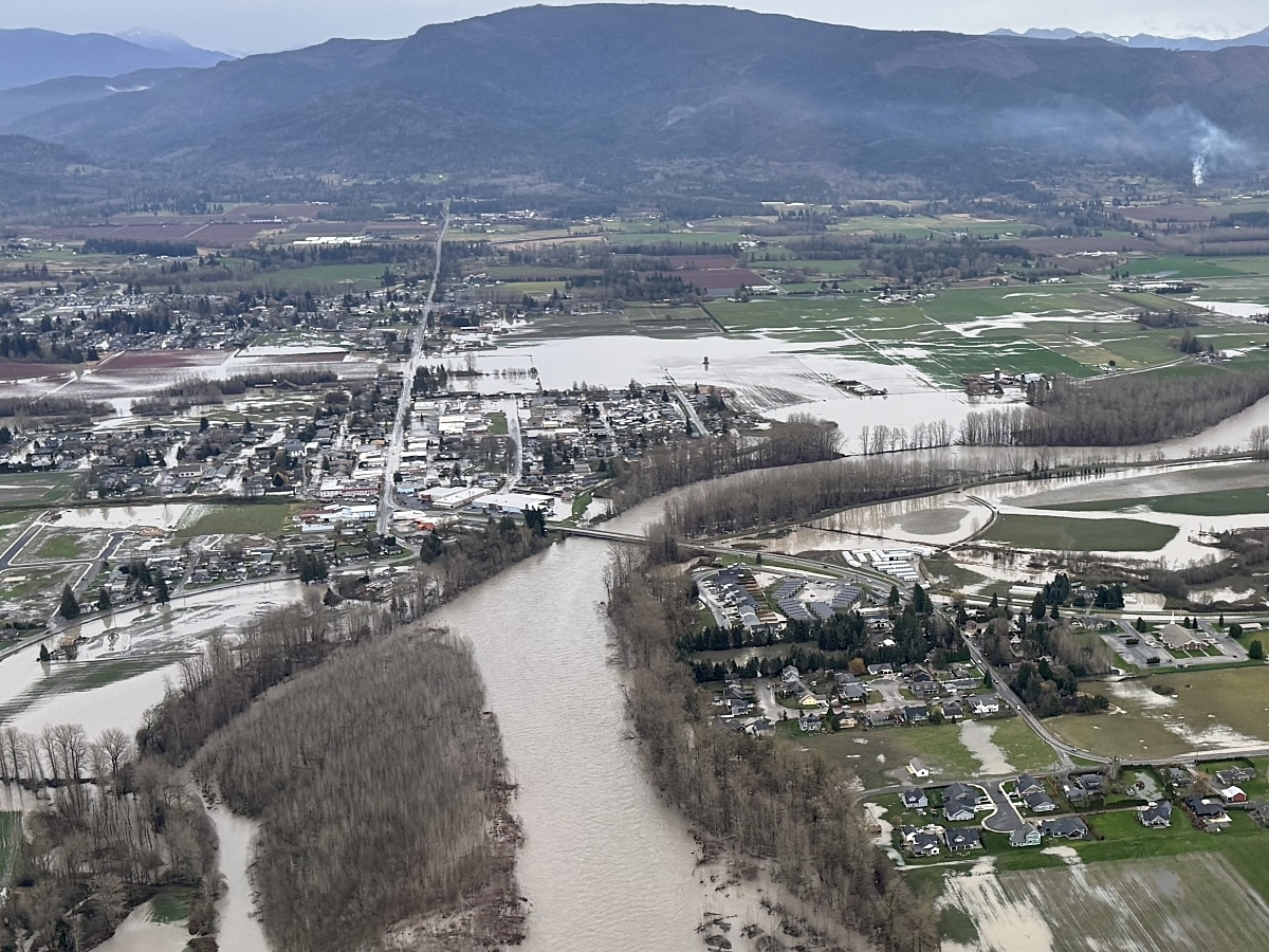
The technical assessments have confirmed what many observers have said for years: the accumulation of sediment in the Nooksack’s channel is increasing its propensity to flood.
All rivers naturally deposit, transport, erode and move sediment like gravel, sand and silt. The movement of that sediment influences how a river flows and how its path changes over time. As with most rivers that run through populated areas, the shape of the Nooksack’s course and its sediment loads have been heavily influenced by human infrastructure such as levees and roads. The human influence is most clearly seen south of Everson, where it constrains the river in an increasingly narrow and unnatural way.
The infrastructure has limited the river’s natural tendency to move across the landscape, cut new channels when older ones become clogged by sediment, and transport sediment downstream toward the Pacific Ocean. Without the ability to chart new courses around silt and gravel bars, the river’s waters must go over them. That, the Whatcom County analyses say, has increased the river’s flood threat. (Other research has also suggested that warmer winter temperatures are significantly increasing the frequency of winter floods by turning slow-melting snow to rain that fills rivers at the same time.)
Although many locals have called for the resumption of large-scale sediment removal, scientists, Whatcom County government officials and the Nooksack Tribal Council say doing so would have a minimal long-term impact that doesn’t justify the impacts sediment removal would have on salmon.
One study suggested the river deposits sediment 10 times more quickly than humans can hope to remove it.
The Nooksack Tribal Council has not responded to requests for an interview, but released a statement in January saying that it would support sediment management, so long as it is part of a large-scale management plan that would broadly reduce risks along the entire river.
“Protecting treaty-reserved rights and salmon habitat is not a trade-off against human safety,” the statement said. “Healthy rivers and functioning floodplains help store water, manage sediment and reduce flood impacts over time.”
Instead of removing sediment, officials have been working for years on plans that could restore the river’s natural ability to manage itself and its so-called sediment “budget.” Those plans reflect continent-wide shifts in flood management strategies that focus on restoring wetlands and increasing the space afforded rivers in order to allow them to absorb more water following storms and rapid snowmelts.
Along the Nooksack, the focus has been on a short stretch of river immediately upstream from Everson and its highway river crossing. The Everson bridge, and an increasingly narrow channel upstream of it, currently functions as a bottleneck. During flood events, water backs up behind the bridge and rises to the point where it flows across the road and into the Sumas River, a normally slow-moving Fraser River tributary. From there, the water flows downhill to Canada.
Widening the funnel would provide more room for the river to chart its own course upstream of the bridge, coupled with changes to enable more water to pass under, or around, the bridge currently serving as the bottleneck.
The plans
Officials have considered a half-dozen potential changes. Some of them — including raising the road to prevent future northbound floods — have been rejected because of concerns about their potential to aggravate flooding elsewhere.
But design work on widening the funnel and related concepts with more modest impacts is proceeding.
Whatcom County’s Jed Holmes told The Tyee that officials are prioritizing concepts that can be completed relatively soon, while continuing work on larger projects that take more time and money.
“There’s a lot of public pressure to start moving forward on something,” Holmes said. “We’re walking into this thing [saying] we want to do all of these things, but also knowing we don’t have the money to do it all.”
This year, the Washington State Department of Transportation is planning to replace a culvert with a bridge span that could help move water around the bridge.
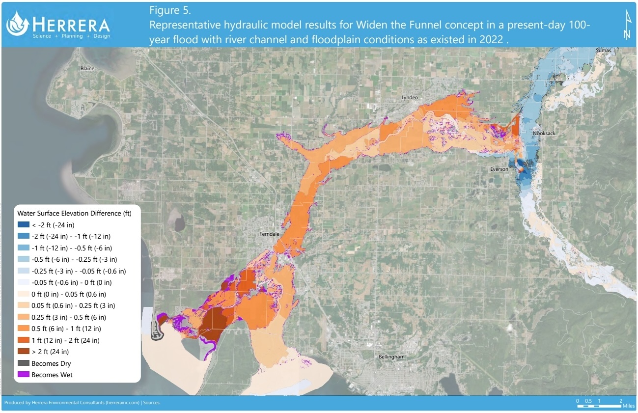
The county has tried to model the benefits — and costs — of various changes.
The modelling has resulted in new maps that provide a detailed look at the no-win scenario that has stymied flood mitigation efforts for decades.
The maps show that although the “Widen the Funnel” concept could ease northbound flooding, it may also increase the height of floodwaters by as much as a foot along more than 20 kilometres of the river downstream of Everson.
“I think everyone kind of agrees that we want less water going over that overflow,” Holmes said. But, he added, that “means we’re going to send it somewhere else.”
The buildup of sediment all along the river means that the flood risk both north and downriver of the overflow will still be higher than it was in 2006, according to modelling and Whatcom County flood manager Paula Harris.
Larger-scale interventions that would bring greater benefits to Canada would also result in larger consequences for downriver U.S. communities.
A 2023 analysis showed that fully blocking floodwaters from heading to Canada would significantly increase water levels in surrounding areas. Similarly, another analysis that considered the potential of building berms around Sumas and Everson showed significantly higher water levels just outside of town. The county has halted planning work on both concepts.
While Washington state has funded the modelling and analysis for flood mitigation concepts, Whatcom County will need more money to turn them into a reality. That funding will also need to go towards reducing the impact any changes could pose elsewhere in the region, Holmes said.
“It’s this, unfortunately, lengthy time process of figuring it all out,” Holmes said. “Then we have the ability to go to the people who actually have the budget and capacity to fix it all.”
In the United States, that often means the Federal Emergency Management Agency.
Holmes said the county is balancing the public’s demand for improvements with the knowledge that past attempts have failed to impose order on nature.
“We had certain solutions put in place, but they didn’t last long because the river keeps on delivering the sediment,” he said. “The river is changing the landscape and our solutions did not take that into account.”
Even the solutions now under consideration come with an expiry date — they’ll work for maybe 50 years, Holmes said. The bigger challenge, he said, is finding a way to allow people to live with the river for centuries, not decades.
When he thinks about that future, Holmes looks at an aerial photo of the river from the 2021 flood, when the Nooksack swelled to a mile wide in places.
“When I look at that, well, that’s the outline of the corridor we need to create for the river, right?” he said. “That’s the 200-year solution.”
The view from Canada
For authorities north of the border, Whatcom County’s plans confirm the need to prepare for future disasters rather than hope Americans will eliminate the Nooksack’s northbound flood risk.
B.C.’s intergovernmental framework, signed in October 2023 with Washington state and various local governments and First Nations, has already improved the sharing of information during flooding. Last year, emergency managers in B.C. were better able to prepare for the arrival of water from the United States. The cross-border agreement has also helped facilitate the replacement of a Washington state culvert, sediment modelling along the Nooksack and research into Sumas watershed aquatic habitats. But those improvements wouldn’t forestall disaster were another 2021-scale atmospheric river to hit the region.
For Abbotsford Mayor Ross Siemens, the focus remains on work that can be done in Canada to prepare for a future flood.
“We continue to lean in and stay involved in that discussion, but that doesn’t necessarily change what we do on our side of the border,” Siemens said. “We know that water is going to come north.”
Over the last five years, Abbotsford has undertaken a handful of projects to bolster the flood defences that crumbled in 2021. Many of the projects have received funding support from the provincial government.
But just like south of the border, longer-lasting flood protection work remains on hold, awaiting funding.
The City of Abbotsford has laid out a large flood management plan that would involve reconfiguring dikes to funnel water through a floodway, away from structures, under critical infrastructure and towards a massive pump station. The pump station would then allow water to be drained from the western part of Sumas Prairie during Nooksack floods when the Fraser River is too high to allow for natural drainage.
Although the province has pledged its support, the federal government rejected a 2024 funding application for the project.
Immediately after last December’s flood, Siemens sharply criticized the lack of federal support for the city’s flood mitigation plans.
In February, Siemens and Sumas First Nation Chief Dalton Silver visited Ottawa to press for federal funding. They returned with a joint promise from both the federal and provincial emergency management ministers to support long-term flood risk mitigation measures.
Siemens is now striking a more positive tone.
“The level of engagement is much higher than it has ever been,” he told The Tyee. He said officials have been stressing the importance of Sumas Prairie as a national transportation corridor. “I am cautiously optimistic that we’ve got their attention and they understand the severity of the issue.”
The federal government rejected The Tyee’s request for an interview with Emergency Management and Community Resilience Minister Eleanor Olszewski. It instead provided a statement saying the government “recognizes the frustration of residents who have been impacted.” The statement put responsibility for flood prevention work on other levels of government, but said the federal government “has stepped up its engagement over the past year to support this work.”
The ministry said Anthony Housefather, the parliamentary secretary to the minister of emergency management and community resilience, was set to attend an April 17 meeting at which leaders will hear of work being done on a new watershed flood mitigation plan. ![[Tyee]](/design-article.thetyee.ca/ui/img/yellowblob.png)
Read more: Politics, Environment










Tyee Commenting Guidelines
Please note that email notifications for replies are not currently working due to a software issue which may be resolved in a future update.
Comments that violate guidelines risk being deleted, and violations may result in a temporary or permanent user ban. Maintain the spirit of good conversation to stay in the discussion and be patient with moderators. Comments are reviewed regularly but not in real time.
Do:
Do not: