


[Editor's note: This is the third of eight excerpts from Patrick Condon's new book Seven Rules for Sustainable Communities: Design Strategies for the Post Carbon World. This series, running Wednesdays and Thursdays for four weeks, offers just a sampling of Condon's vital guide for green planning; interested readers are encouraged to seek out the book.]
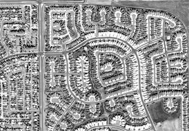
Street systems either maximize connectivity or frustrate it. North American neighbourhoods built prior to 1950 were rich in connectivity, as evidenced by the relatively high number of street intersections per square mile typically found there.
Interconnected street systems provide more than one path to reach surrounding major streets. In most interconnected street networks, two types of streets predominate: narrow residential streets and arterial streets. In this book, for reasons explained in the most recent excerpt, we call these arterial streets in interconnected networks "streetcar" arterials.
On the other end of the spectrum are the post-Second World War suburban cul-de-sac systems, where dead-end streets predominate and offer only one path from home to surrounding suburban arterials. This cul-de-sac-dominated system can be characterized as dendritic, or "treelike," the opposite of the web of connections found in interconnected systems.
Streets in this system all branch out from the main "trunk," which in Canadian and U.S. cities is usually the freeway. Attached to the main trunk of the freeway are the major "branches," which are the feeder suburban arterial streets or minor highways.
These large branches then give access to the next category down the tree, the "minor branches," which are the collector streets. Collector streets then connect to the "twigs and branch tips" of the system, the residential streets and dead-end cul-de-sacs.
Shorter trips
The major advantages of the interconnected system are that it makes all trips as short as possible, allows pedestrians and bikes to flow through the system without inconvenience and relieves congestion by providing many alternate routes to the same destination.
The major disadvantages of the interconnected street system are that no homes are completely cut off from the irritation of outside traffic and that it uses more linear feet of street per standard-sized lot than does the dendritic system.
The major advantages of the dendritic system are that it shifts trips away from homes lucky enough to be located at the ends of cul-de-sacs, allows cars to flow easily through the system if it has been optimally designed, and requires fewer linear feet of road length per standard-sized lot.
The major disadvantages of the dendritic system are that almost all trips are made longer than they would be if the system were interconnected and that it is prone to congestion since it provides no alternative routes away from main intersections.
A tree with deep roots
Despite its disadvantages, the dendritic system has become a ubiquitous feature of urban districts built since 1950. The complex industry that creates new communities is so thoroughly committed to the dendritic street system that alternative thinking is no longer supported.
Most municipal and regional transportation planners and engineers speak only in the language of the "street hierarchy," or the hierarchical categorization of streets.
Jurisdictions typically have a full set of regulations that assume all road systems are dendritic, making it impossible for interconnected streets to be understood. For example, the Salem, Ore., planning department requires new developments to assign categories from this hierarchy to all streets in a proposed land subdivision before the proposal can be approved.
In 2003, the proponents for a sustainable new community at the former Fairview State Training Center in Salem argued that their proposed interconnected street system was essentially without a flow-concentrating hierarchy and, rather, was designed to distribute traffic throughout the network. Unfortunately city planners and engineers did not have the discretion to accept this argument, feeling that their own policies made a categorization unavoidable.
Having failed, the proponents reluctantly identified as the "arterial" the community's proposed "High Street," where shops and community facilities such as libraries and schools were proposed.
Unfortunately, this designation triggered a reaction in the school district where one of their policies prohibited elementary schools located across "arterial" streets from the majority of its students. Here, too, the school officials felt that they had no discretion in the matter and could accept only a plan where the school was placed less accessibly on a "quieter" part of the site.
They recommended putting the school at the end of a cul-de-sac, with ample space for "mothers to drop off their children in cars every morning." At no point did they take seriously the master plan's imperative that the school should be "centrally located to make walking convenient and to make the school the symbol of the community."
Inflexible models
A second example: In 1998, the City of Surrey partnered with UBC's Design Centre for Sustainability to design a new "sustainable community" based on principles similar to the ones in this book.
An interconnected modified grid system was designed. All of the charrette participants, including the consulting engineer, understood and supported the logic of the interconnected grid. But when the engineer was required to model the performance of the system, she had to artificially assign a hierarchy to the road system or the traffic-flow software simply would not run. Thus, even the modelling software acknowledges only one kind of system -- the dendritic system.
These decisions, driven by a deeply flawed street taxonomy and a tendency to narrowly focus on one issue to the exclusion of all the related sustainable community demands, has left us with neighbourhood configurations where people are forced to drive more than they should.
Studies show that the dendritic configuration forces residents to drive over 40 per cent more than residents in older, streetcar city neighbourhoods. This results in a 40 per cent increase in greenhouse gas emissions per car; given that households in these systems are likely to own two or more cars, their GHG contribution per household is easily double that of residents of traditional streetcar districts.
Dendritic streets: Good for cars, bad for people
The basic problem with the dendritic system is that all trips collect at one point, usually at the major intersection of two suburban arterials or at the on ramp to the freeway. With all trips in an area feeding to one point, that intersection will typically receive up to four times more trips than an equivalent intersection in an interconnected system.
With all of these trips forced through one pinch point, congestion is inevitable. It is only through dramatically widening these intersections that such congestion can be alleviated.
Huge expenditures for widening suburban intersections are now routine, with nine or 10 13-foot lanes, and right-of-way intersections that are 200 feet (or more) wide. While many of these intersections admirably handle the turning motions and through trips for 60,000 or more car trips a day, they are almost impossible to cross on foot, particularly for infirm pedestrians.
One study of pedestrian deaths in the Orlando area identified just such a landscape as a pedestrian death hot spot, the worst in the region. Apparently, many customers were foolhardy enough to try to trek on foot from one popular restaurant to another across the 10-lane arterial street that separated them, and there these pedestrians met their end. It would have been infinitely more intelligent to drive.
Transit systems seldom work well in dendritic systems either, since the passenger drop-off point is still hundreds of yards from their destination, separated from the street by acres of sun-scorched or wind-blown parking lot.
Streets on a human scale
Major streets within interconnected street systems often work quite differently than in suburbs. The interconnected Broadway corridor in Vancouver carries 60,000 vehicle trips a day. Were it redesigned to suburban (dendritic) standards, Broadway would require at least nine wide travel lanes, including three turn lanes at each intersection.
It currently operates with only four narrow through lanes, no turning lanes and two parking lanes. The parking lanes are used for through traffic during rush hours, a double use of a lane that is common in older communities but unheard of in new ones.
Left turns are restricted at many intersections to keep traffic moving smoothly. The lanes are a relatively narrow 10 feet, with a consequent curb-to-curb crossing distance of 60 feet, less than half the distance of the comparable suburban intersection.
Crossing times for pedestrians, even infirm ones, are reasonable over this distance. The remaining space is taken up by 15-foot-wide sidewalks serving a continuous line of storefronts. The surrounding grid of streets provides alternative options when this intersection is congested, alternatives that do not exist in the dendritic systems.
Drivers frustrated from making lefts always have the option of using the adjacent street grid to position their car on a perpendicular intersection and reach their destination that way.
Big boxes
Another consequence of dendritic street systems is that they favor big box developments over other, more neighbourhood-scale developments. When tens of thousands of trips are made through an intersection per day, the major big box chains take an interest.
Their store location formulas depend almost entirely on a combination of two factors: (1) the income range of families in the service area as taken from the census data and (2) the number of trips per day through the intersection adjacent to the site they are considering.
The service-area calculation is based on the distance potential customers might be willing to drive to get to the store (for example, 20 minutes). Obviously, the more the public spends on a smooth-flowing, auto-oriented infrastructure, then the longer the radius line for the service area, the larger the potential customer base and thus the bigger the store must be.
In this way, we see the connection between ever greater expenditure on suburban road infrastructure and ever larger stores that capitalize on this public expenditure. As more stores locate in busy commercial areas, the gravitational forces these stores exert on the system lead inevitably to congestion, as whatever capacity the system provides is used up by the decisions of big box corporations.
Interestingly, Home Depot Corporation has recently changed the way it calculates store locations and size, moving to smaller stores more frequently located in the urban landscape. Why? Because increasing congestion in U.S. and Canadian cities is shrinking the distance consumers can dependably drive in 20 minutes, and as it shrinks the Home Depot "big" box is shrinking as well.
Gated communities
Whatever one's opinion of gated communities, they are highly compatible with dendritic systems and generally incompatible with interconnected systems.
Dendritic systems by their nature require developments to occur in pods, with usually only one access point into surrounding collectors or arterial roads. These arterials are usually unattractive and pedestrian unfriendly ("car sewers," in the words of Geography of Nowhere author James Howard Kunstler).
The gate serves less to ensure safety than to mark a congenial and attractive inside from the threatening and often very unpleasant exterior of the suburban arterial. Social critics often remark on the insularity and inherent inequity of gated communities but seldom link their emergence with the dendritic street network, which makes them inevitable.
On the other hand, interconnected systems leave development increments that are usually too small for gated communities. Even exclusive projects located on typical five-acre urban blocks cannot be truly gated and are therefore less appropriately subject to the criticisms leveled at typically much larger gated projects in suburban dendritic street systems.
Connecting a healthy landscape
It's a simple idea: interconnected streets, good; dendritic streets, bad.
What gets complicated is unpacking all the unhealthy habits that conspire to block a logical return to interconnected worlds and neighbourhood health. The interconnected street system is the very armature of a healthy urban landscape. Preserving interconnectivity in areas where it exists and finding ways to build it into areas where it has been frustrated should always be part of the therapy.
In new suburban developments of 40 acres or more, interconnectivity should be a first principle, even if this results in a small island of connectivity in a sea of dendritic pod development.
Many New Urbanist projects hold firm to this principle even though the value of internal connectivity is limited in such a context, and good for them. But a 40-, 60-, or even 200-acre area of interconnected street systems will do little to reduce vehicle miles travelled if the surrounding area is still dominated by the dendritic road hierarchy.
Once you reach the edge of your walkable world, you are still stuck needing a car. Thus, a willingness of developers to produce walkable neighbourhoods is futile unless policy makers responsible for the larger landscape address rules governing the development of the larger transportation pattern and find ways to ensure that the regional street system stays interconnected.
Portland, Ore., again provides a good example for how to do this. Portland's Metro Planning Council is working hard to impose an interconnectivity standard requiring a through street at least every 600 feet.
Simply brilliant
The brilliance of this standard is its simplicity. It represents a measured and reasonable requirement from the public sector, ensuring the public good is represented while not unduly proscribing the actions of the development community.
It would lead inevitably to some set of patterns that would emulate the function of the traditional North American 640- by 320-foot block and the streetcar city districts within which such blocks were situated.
Finally, it creates a policy framework where individual projects with interconnected internal systems can be integrated into an interconnected whole, allowing new projects to be extensions of predetermined systems rather than mere subdivisions of discrete parcels of land.
Of all the challenges presented in this book, getting the street system right may be the most daunting. Once a street is in place, it is almost impossible to change. Rome, Italy, is a brilliant example of this, where buildings have been built and then destroyed many times on the same parcel while the streets have stayed the same.
Although there is still time to adopt a more reasonable standard for necessary new development, existing suburban areas dominated by dendritic street systems will always remain obstacles in the way of cutting car dependence and the GHG that this inevitably generates.
Wherever large areas of dendritic streets exist, ways must be found to mitigate their failures, notably by capitalizing on the latent capacity of arterial strip commercial streets. Wherever existing interconnected streets exist, they must be protected and fortified with increased activity.
Wherever opportunities for appropriate new greenfield development exist, they must be designed with interconnected streets with an eye toward re-creating the streetcar city form that has served us so well in the past.
Tomorrow: Rule 3 -- Locate commercial services, frequent transit and schools within a five-minute walk. ![]()
Read more: Transportation


Tyee Commenting Guidelines
Comments that violate guidelines risk being deleted, and violations may result in a temporary or permanent user ban. Maintain the spirit of good conversation to stay in the discussion.
*Please note The Tyee is not a forum for spreading misinformation about COVID-19, denying its existence or minimizing its risk to public health.
Do:
Do not: