Opinion

Why Transit Is Key to a Culturally Vibrant City

Mapping where immigrants settle shows Metro Vancouver's transit nodes are cradles of the region's cultural diversity.

By Erick Villagomez, 17 Nov 2010, re:place magazine

ImmigrationVancouver

Portion of graphic showing the geographic distribution of incoming immigrant populations in Metro Vancouver from 1981 to 2006. To see the entire graphic click here.

Related

Our country prides itself on its ethnic diversity. This goes hand-in-hand with a general openness to immigrants who bring the many wonders that their respective cultures have to offer, from all corners of the globe.

More often then not, our cities are the first stop for immigrant populations looking to come into Canada. This is no surprise since urban environments offer the wide range of services, amenities, and employment opportunities necessary to ease the transition into an unfamiliar cultural environment.

Over the past few decades, Vancouver has grown as a significant landing pad for incoming immigrant populations and although the locations where incoming immigrants have chosen to start their lives in the city are somewhat known, they are really only discussed in general terms and often in reference to "cultural pockets" that have matured enough to be readily visible.

Enshrouded by this blanket of generality, the underlying forces that shape the decisions of immigrant populations looking to call Vancouver home often go unnoticed. 

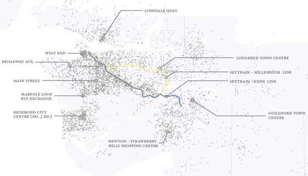
This drove the development of the map you can see by clicking here that charts the locations of incoming immigrant populations to Metro Vancouver from 1981 through to 2006. To be more specific, this graphic compiles the spatial distribution of incoming immigrants by census tract for the years of 1981, 1991, 2001, and 2006.

I chose to combine all of the information into one graphic as a means of highlighting larger patterns that are less visible when looking at each year individually. This occurs as the cumulative effect of overlapping dots form dense clusters across the metropolitan landscape.

I've taken the liberty of labeling the locations of the most significant clusters and reference the main infrastructural elements (i.e. Broadway, the Skytrain lines, transit nodes, etc.) that seem to play a part in the locations chosen by immigrant populations.

Although clusters are distributed throughout the region, the tie that binds these dense nodes is access to transit. The largest clustering occurs as a diagonal swath across the region alongside the Expo Line from Vancouver through to New Westminster. Less so along the Millennium Line given that it was only recently completed (in 2002) at the time of the census. The Canada Line, of course, wasn't built yet so is not included in the graphic.

Travel goes both ways

Consequently, those who decided not to live near Skytrain lines, found locations that were close to regional transit nodes, such as Guildford Town Centre, Richmond City Centre, or Lonsdale, that allow for easy access to transit.

With this in mind, it is no surprise that Metro Vancouver's transit nodes are the cradles of our regional cultural diversity. Both are intertwined in a symbiotic, mutually supportive relationship whereby immigrants move near transit nodes that allow them to travel around the city; over time, as more immigrants move to these areas, they begin to establish themselves as a neighbourhood with entrepreneurs opening culturally-specific businesses nearby.

This, in turn, attracts "outsiders" interested in experiencing and partaking in the unique culture (events, food, etc.) available in the area and who can exercise the use of transit.

The reason for this pattern is straightforward, being the directly result of the needs of incoming immigrants who require accessible transit as a means of navigating the city in the absence of cars and drivers licenses. Only once they get more established -- financially and otherwise -- can they move to break their dependence on transit.

Affordable housing is key

Also related to the need for transit is the necessity for a variety of housing options around transit nodes. This is to say that house types that can support the needs of immigrant populations (i.e. with extended families, etc.) -- that can be rented or bought affordably -- are a prerequisite for incoming immigrant households.

Understanding this pattern is particularly relevant now, as increasing pressures to develop and densify transit nodes are radically altering existing neighbourhoods around Metro Vancouver. All too frequently, this means the construction of expensive condominiums catering primarily to two person households -- building types that offer developers the highest return on investment. Yet, as the graphic clearly demonstrates, among many of the benefits that a good transit system brings, one of the most important is supporting the immigrant populations that bring so much vibrancy, life and diversity to the region.

So as we exercise our powers of creative destruction and continue to reshape our cities around transit hubs, we must ensure to meet the needs of this transitioning population explicitly in terms of diverse housing and transportation options. A failure to do this literally puts the social health and energy of the region at risk.

[Editor's note: For a related article, with animated map, by the author looking at the spatial distribution of incoming immigrant population information between 1981 and 2006, and viewing the data in sequence over time, go here.  [Tyee]

11  Comments:

Login or register to post comments

  • Urbanismo

    1 year ago

    Senor V's parochialism

    "Our country prides itself on its ethnic diversity." . . . true and with just about every city in the world, even before globalization.

    Being WASP am I allowed to include myself in that "ethnic diversity" " . . . cities are the first stop for immigrant populations looking to come into Canada." It certainly was for me: Kerrisdale to be precise.

    But why start tracking since 1981. I came in 1951 and already the Chinese were way ahead by way over half a century. Around the same time I came Germans were establishing themselves on Robsonstrasse, Greeks in Kits, The Italians on Thu Drive, indeed they made Commercial drive.

    Skytrain doesn't remotely track ethnicity: it goes, way after the great ethnicity surge, dead set, along Kingsway to NewWest plunk! I thinq Mr. V is way out of line stating " Consequently, those who decided not to live near Skytrain lines . . . "

    Guilford came out of the LMRB's, we're talking the late '50's, idea of regionalism and was developed by Grosvenor-Laing of British Properties fame. He is promoting an agenda rather than stating fact: his urban memory is soooo limited.

    "So as we exercise our powers of creative destruction and continue to reshape our cities around transit hubs . . . " I dunn about "creative" but "destruction" yes!

    Indeed, our cities would have a better chance at creative development if it were the other way around: transit hubs created around our established neighbourhoods instead.

    Mr. Villagomez, surprisingly . . . belying his name . . . surprisingly, shows a profoundly limited urban parochialism.

  • alive

    1 year ago

    ass backwards

    Location, location, location! the developers motto.
    They are the ones who decide where the new housing happens, and then people go there.

    As soon as a new transit route is planned the speculators buy up every plot of land around the stops, is that news?

  • freebear

    1 year ago

    Too many 'keys'

    being researched, while the same old planning (more roads and seperation) and political vision (less) is implemented; resulting in more, or less, more of the same.

  • pdfwriter

    1 year ago

    cause and effect

    Or perhaps transit connections gets built where there are lots of people (immigrants and locals alike).

  • RickW

    1 year ago

    Wasn't there a Tyee article some time back.....

    ..... that stated some 400 km of light rail could have been built for the cost of the RAV line?

  • David Beers

    1 year ago

    Administrator

    RickW, I think this is the story you mean

    http://thetyee.ca/News/2008/06/05/UpWithTrams/

    but the figure is 175 km of light rail lines for the cost of a Skytrain line to UBC.

  • carfreecity

    1 year ago

    transit

    auto traffic is now so intolerable everywhere.
    pedestrians should be supplied with free gasmasks and earplugs or maybe ipods

  • RickW

    1 year ago

    David Beers

    Maybe it was this, where the number add up to about 400km:

    http://thetyee.ca/News/2009/03/25/LightRail/
    For the same money, concluded the team, the government could finance a 200-kilometre light rail network that would place a modern, European-style tram within a 10-minute walk for 80 per cent of all residents in Surrey, White Rock, Langley and the Scott Road district of Delta, while providing a rail connection from Surrey to the new Evergreen line and connecting Pitt Meadows and Maple Ridge into the regional rail system.

    When the UBC SkyTrain line was announced last spring, Condon and Dow produced a study showing that the same money could build a 175 km lattice of light rail lines restoring Vancouver's former trolley system and extending into bordering locales.

  • bizcheers

    1 year ago

    good for criminal too

    people should know about the possibility of increase traffic service. at the same time, cirminal increase too since it could be better way to travel anywhere after they did some wrong thing.
    the good way is increasing control power if not please do not make many quick escape door open.

  • Stephen Rees

    1 year ago

    Richmond

    Prior to the arrival of the Canada Line last year, no one could really state that Richmond allowed "for easy access to transit" and cannot seriously be thought that was a reason why immigrants would settle here.

    As usual, we seem to be confusing coincidence with casuality

  • Joseph Jones

    1 year ago

    Heartless Destruction

    On 4 Nov 2010, Vision and NPA councillors joined forces to override the prevalent desire of Norquay residents in East Vancouver for a human-scale neighborhood. Our thousands of residents and hundreds of acres are now headed toward formal rezoning for – as Villagomez puts it – "building types that offer developers the highest return on investment." The map demonstrates that a high proportion of recent immigrants live in Norquay (centered on Kingsway between Gladstone and Killarney Streets). The relatively affordable housing now enjoyed by our 32% low income families will begin to disappear. The City had no trouble forking over $10,000 for a consultants report on how developers could be incentivized. But no money could be found to survey existing residents or to assess social impacts. The only thing that counted in the end were facile planner assertions, supported neither by reliable data nor by the affected community itself.

    • The discussion for this story is closed. No more comments can be added.