

[Editor's note: This is the eighth of eight excerpts from Patrick Condon's new book Seven Rules for Sustainable Communities: Design Strategies for the Post Carbon World. But the series isn't over. Next Wednesday we finish up with a Tyee exclusive: Patrick Condon's "Seven Rules for Sustainable B.C. Applying These Rules Here at Home".]
In the last excerpt we looked at the main arteries of the watershed and how they can become the main armature for urban design. Here, we look at the most tertiary branch tips in the urban watershed, the streets and the parcels they serve.
Road and stormwater infrastructure often destroys the ecological function of the land that supports it and burdens home buyers and taxpayers through its cost to install, maintain and replace. Since the end of the Second World War, the per dwelling unit cost for providing, maintaining and replacing infrastructure (defined here as the physical means for moving people, goods, energy and liquids through the city) has increased by nearly 400 per cent according to some estimates.
Most of this per capita increase has been the consequence of ever more demanding engineering standards for residential roads, coupled with the gradual increase in per capita land demand over the decades (or at least until the year 2000), a consequence of universally applied sprawl patterns throughout the United States and Canada.
The first costs of these ever more odious engineering standards and ever more exclusive zoning regulations were often invisible to the taxpayer, buried as they were within the costs of the original home purchase.
These costs become more obvious to the taxpayer after two generations, when the costs associated with the necessary replacement of infrastructure fall not on the home purchaser but on all property tax payers.
First-ring suburbs built during the 1950s and 1960s now face major costs for overhauling an overextended system of roads and pipes; because of low-density development, these suburbs do not have enough taxpayers to cover those costs.
Outward bound
Faced with rising property taxes and a falling level of services, residents of first- and second-ring suburbs simply opt out, leaving behind those communities for the greener fields of the third- and fourth-ring suburbs or even exurbia.
Decaying oversized infrastructure in need of replacement provides strong financial incentives for residents to move farther away from the geographic core of the region and farther away from jobs and services.
An alternative to this grey, expensive and heavy infrastructure -- and a topic of this chapter -- is "green infrastructure" for roads and drainage. Green infrastructure is defined herein as roads and drainage systems that work with, and not against, natural systems. It manifests itself in a set of engineering and construction standards that make road and drainage infrastructure lighter, greener, cheaper and smarter.
Every dollar's worth of pavement produces a measurable increase in environmental impact. Pavement fundamentally alters where water goes when it rains.
Water that should go into the ground goes into a pipe instead, utterly transforming watershed performance. The cure for the sickness inflicted on watersheds consequent to urban development is to spend less on infrastructure, not more -- less pavement, fewer pipes, fewer inlets, fewer gutters.
Infrastructure exists that costs less than what we are currently requiring and that works with nature's systems rather than against them. This is infrastructure that capitalizes on nature's services while minimizing the weight, extent and cost of the "hardscape" -- the streets, walks, lanes and drainage ways of the site.
Green infrastructure can significantly reduce cost while dramatically shrinking environmental impacts.
Watershed function
We start by repeating the first principle for ecological design introduced in the last chapter: The site is to the region as the cell is to the body.
And as the cells in the body are composed mostly of water, so too is water any site's most important ecological element.
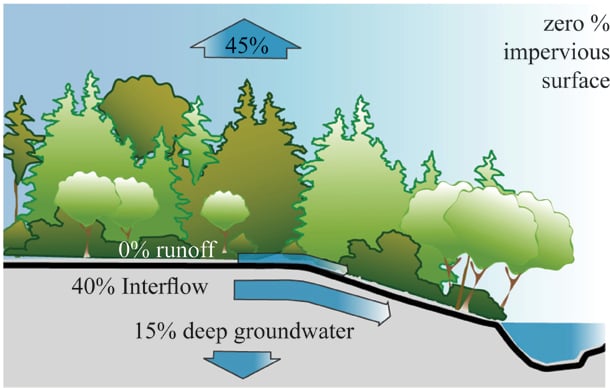
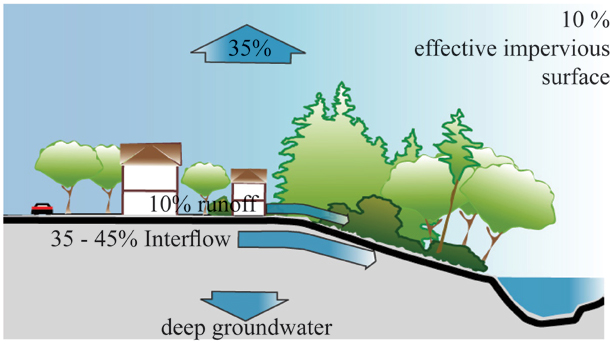
In most North American natural landscapes, the vast majority of rainwater that falls on the ground is infiltrated by the soil or absorbed into plants. Plant roots draw rainwater from shallow soils and then send it back up into the sky through the leaves (a process called transpiration).
The water that the plants do not need or cannot absorb flows through the soil to be stored in the water table or drained from the soil via a nearby stream. The relative ratio of water transpired versus water absorbed varies from place to place and from season to season.
Water quality and water quantity
Throughout North America, the conversation about watershed health has been inordinately focused on water quality -- the degree to which water discharged into receiving waters carries pollutants -- as opposed to water quantity -- the degree to which urbanization alters the rate and amount of water discharged into receiving waters.
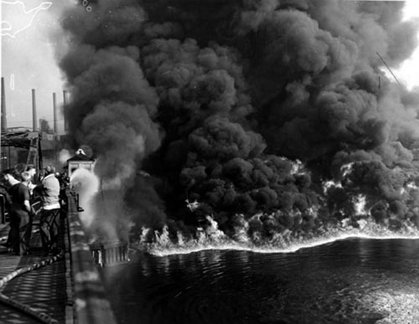
This is a legacy of the first North American environmental movement, when concerns about polluted water (sparked by many notable events, including the Cuyahoga River fire) led the United States to pass the Clean Water Act of 1972.
Today, the Clean Water Act is still the only regulation governing U.S. water quality, and all 50 states have, to a greater or lesser extent, aligned their policies with it. The original act clearly obligates states and lower levels of government to protect America's waterways, with a goal of keeping all U.S. waters "swimmable and fishable," if not drinkable.
But the act was mute about the damage wrought on American waterways by alterations in the quantity of water that moves through its thousands of streams. At the time the act was passed, very little was known about how devastating changes to streamflow can be.
In the decades since it was originally passed, the act has been updated by adding the "TMDL rule" (for "total maximum daily load" of suspended solids), which can address stream degradation by regulating siltation. But the act's essential focus on "water quality" has never changed, making it an unwieldy instrument for regulating water quantity.
In the Pacific Northwest of the United States and in Pacific Canada, the water quantity changes brought about by urbanization have produced a crisis.
A threat to salmon
By 1999, the U.S. Fish and Wildlife Service, acting in conformance with the mandates of the Endangered Species Act of 1973, listed five species of Pacific salmon as "endangered." This triggered a requirement for other jurisdictions in the states of California, Idaho, Oregon and Washington to respond in a way that ensured no further harm to these species.
Unfortunately, on the list of harmful activities that affected fish, urbanization was second only to forestry.
How is it that a land use that covers less than 10 per cent of these states could be so damaging? One reason is that when people build cities they tend to choose the same places where salmon spawn and rear.
Spawning and rearing occur on stream runs that are between one per cent and five per cent gradient. These gradually sloping but not entirely flat streams occur in gradually sloping but not entirely flat landscapes -- exactly the landscapes that are appropriate for building cities.
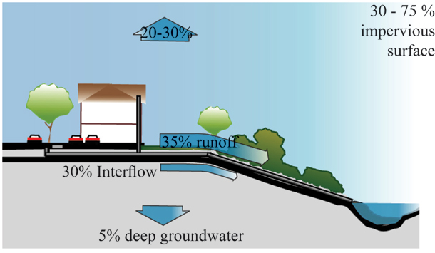
The second reason is how profoundly urbanization, even at suburban densities, alters watershed performance.
When an area urbanizes, conventional stormwater practices require the installation of a stormwater infrastructure over potentially vast percentages of salmon habitat. This stormwater infrastructure functions in a way that is 180 degrees contrary to how natural landscapes perform.
The deluge
Rather than holding water in the soil, where it can be cleaned and delivered to streams over weeks or even months, a network of pipes is installed to ensure that the same amount of water is delivered to the stream within a few hours, or even a few minutes, of a rain event.
Thus, water that had previously been slowly metered out by the soil -- clean and at the temperature required for fish health -- is flushed immediately in amounts that can be tens, or even hundreds, of times more gallons per minute then predevelopment rates.
This rapid flushing of urbanized landscape produces many serious consequences. The destruction of stream banks is the most damaging of the consequences precipitated by these sudden, unaccustomed deluges.
Stream banks that have taken 10,000 years since the recession of the glacier to stabilize are suddenly asked to accept 10, 20 or even 100 times more water per minute than they can accommodate.
The result, unsurprisingly, is erosion of the stream channel, and the delivery of those silts to lower parts of the watershed. Unfortunately, these silts are typically delivered to the very places that the salmon favour for spawning and rearing -- gravel beds in stream locations with gradients between one per cent and five per cent.
As a consequence of the disruption to urbanized watersheds, the fish-bearing capability of virtually all of our urbanized stream systems has been destroyed. In the city of Vancouver alone, only two of the original 60 salmon-bearing streams still provide habitat.
The loss of these systems not only threatens the extinction of an icon of Northwest life, the wild salmon, but also experientially impoverishes city residents, especially children. What was once a profound and peaceful environment teeming with life and palpably expressive of the rhythms of nature has been erased.
Green streets example: Amble Greene community, Surrey
Most typical residential streets trap water between vertical curbs. Trapped like this, water that should be allowed to infiltrate collects in gutters and flows downhill until it reaches an inlet, leading to a pipe, leading to a bigger pipe, and finally, dirty and hot, gets flushed into the stream.
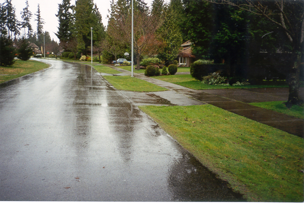
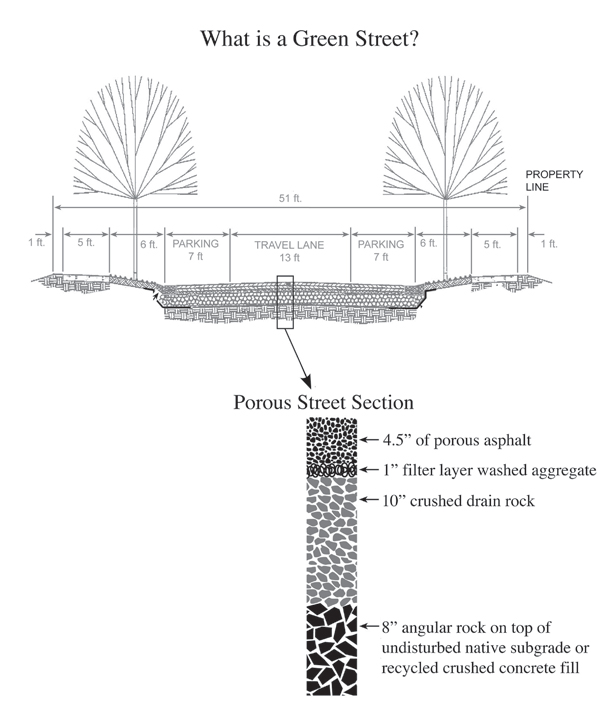
Removing curbs eliminates this problem. Without curbs to block it, rainwater can flow over the lip of pavement into grass or crushed stone verges or boulevards. Rural roads are still built this way, not to preserve watershed function but because it is by far the cheapest way to build a road.
By removing the curb and gently lowering the grassy tree boulevard, broad spaces are made available for infiltrating water.
The 1974 Amble Green project in Surrey provides a good and durable example of this strategy. The curbless streets in this project infiltrate 100 per cent of the water that falls on them. Soil conditions are forgiving but by no means ideal.
Nevertheless, the project infiltrates not our target of one inch per day but four inches -- the amount of rain associated with the 100-year storm event in this city.
Project proponents were required to infiltrate all rainwater that fell on the site because of inadequate off-site city storm drain interceptors. Broad grassy boulevards located between sidewalks and the curbless streets absorb most of the rainfall, with additional infiltration provided by hidden "French drain" infiltration chambers located below.
Occasional "blue-green" infiltration depressions -- large dished areas often in the middle of cul-de-sac bulbs that can hold large amounts of water long enough to eventually infiltrate into soils below -- are the fail-safe backup for the plan.
As this project demonstrates, curbless streets save money and do the job. But in the minds of many, they have one problem: without curbs, what will prevent parking cars from migrating onto the grass?
At Amble Greene, this is largely not a problem, but in the few places where it is, owners have arrived at a simple control strategy. Hand-placed rocks located at the street edge provide enough discouragement.
Naturally less costly
At some point, our tendency to spend more and more per family on roads must surely end. Overextended infrastructure is already bankrupting some communities, and others will follow.
Even at the national scale, there are problems, with estimates of the unfunded demands for upgrading U.S. highway infrastructure in the many hundreds of billions of dollars; it boggles the mind to consider what that number would be if local infrastructure were included. It must be in the trillions.
Certainly, a landscape pattern that is overcommitted to the car and under-committed to transit, biking and walking is the root of the problem. But the tendency to build infrastructure in defiance of natural system behaviours is a linked pathology.
Street systems seem to have been intentionally designed to be ignorant of natural processes. Unsurprisingly, this has caused the destruction of these same systems.
Fortunately, this can be corrected. Lighter, greener, cheaper and smarter infrastructure is certainly conceivable, and in fact already exists. While variations exist across North America, the four rules for green infrastructure are quite simple: (1) infiltrate rather than drain; (2) infiltrate everywhere; (3) infiltrate one inch per day and (4) heavy soils are good soils.
The solutions are not complex; changing behaviors, however, will be. Fundamental shifts will be required in the way the problem is approached and by the people who are at the table trying to solve it.
Decision makers must think laterally about the many issues that touch on street infrastructure, not just about accommodating traffic and removing stormwater. This is even more daunting when we accept the challenge to retrofit the millions of square miles of existing street infrastructure.
Fortunately, we have as much time and energy and resources at hand to fix this problem as we had to create it.
Next Wednesday: A special bonus feature written by Patrick Condon exclusively for The Tyee to finish this series: "Seven Rules for Sustainable B.C. Applying These Rules Here at Home." ![]()
Read more: Environment, Urban Planning + Architecture


Tyee Commenting Guidelines
Comments that violate guidelines risk being deleted, and violations may result in a temporary or permanent user ban. Maintain the spirit of good conversation to stay in the discussion.
*Please note The Tyee is not a forum for spreading misinformation about COVID-19, denying its existence or minimizing its risk to public health.
Do:
Do not: