


[Editor's note: This is the seventh of eight excerpts from Patrick Condon's new book Seven Rules for Sustainable Communities: Design Strategies for the Post Carbon World. This series, running Wednesdays and Thursdays for four weeks, offers just a sampling of Condon's vital guide for green planning; interested readers are encouraged to seek out the book.]
We start by offering this first principle for ecological design:
The site is to the region as the cell is to the body; just as the health of the individual human cell has everything to do with the health of the human body, so too does the ecological function of the individual site have everything to do with the ecological health of the region.
Site-scale elements, when multiplied thousands and even millions of times throughout vast metropolitan regions, do more than influence regional environmental systems; they constitute regional environmental systems.
The most obvious and important regional environmental system is the watershed. Of all the varied influences of the city on environmental function, the influence of urbanization on watershed function is the most profound.
If sites are the cells to the body of the region, then streams and rivers are the veins. If we extend this analogy even further, the rooftops, driveways, lanes and streets of the urban landscape are the capillaries of the system.
Capillaries take water to veins through a hierarchy of ever larger channels until this water reaches the sea. These capillaries and veins form a dendritic, or "treelike," network common to all urbanized landscapes, whether they be desert or rain forest.
A river runs under it
Since the time of the Romans, we have buried this network of rivulets, streams and rivers under our cities. It is still there; it is just hidden in pipes.
This is an expensive, ugly and damaging strategy. Urban green space is too precious to hide. Absent exposure to green space, children growing up in these districts are experientially impoverished.
When all traces of nature have been sterilized from neighbourhoods, a vital connection between nature and citizens has been closed. It is far cheaper, far more beautiful, and far more healing to retain this network as is and to incorporate it as infrastructure.
It should be revealed and used as a system that works with, not against, nature.
From rooftop to yard to driveway to sidewalk to street, urban elements must behave like forest trees, understory plants, forest soils and intermittent water channels. From lane to street to schoolyard to park to preserved natural areas, urban areas must emulate natural areas – the swale like the intermittent stream, the park like the wetland, the ball field like the floodplain and the greenway like the river of the natural order.
These elements must be linked together in an ecologically functional chain – a linked system of natural areas and parks.
Islands in the stream
Linked natural areas and parks reduce greenhouse gas emissions. Stream systems, and their necessary forested buffers, can reduce heat island effects in even new neighbourhoods by the shade they provide and by the air cooling they produce.
Preserved streamway forests also sequester carbon, a significant benefit, even though it takes 50,000 acres of trees to sequester the average annual amount of carbon produced by one American.
But perhaps of even more importance for our cities, linked parks and natural areas can connect urban districts for human purposes. Stream systems are inevitably dendritic, with branch tips reaching every corner of a watershed.
A path system organized around the stream system will thus allow pedestrians and bikes to access every part of the urban district without using streets. Such paths can provide a comfortable, shaded way to travel long distances on foot or on small wheeled vehicles (such as electric scooters), thus offering a logical and organic way to make walking and biking more pleasant and convenient than driving.
Linked parks strategy 1: Plan for nature out front, not out back
Current regulations now typically require developers to preserve stream channels. But these channels are usually located not at the edges of public ways but along rear property lines.
This is a waste of a valuable amenity. Such streams become the destination for stray shopping carts and a convenient dumping area for construction waste. Research has shown that protected and preserved nature contributes to increased average property values many blocks away, but only if designed as a visible and accessible public amenity.
The only way to truly make natural systems into a visible public amenity is to locate them on the "front door" of the community, not out the back –- that is, abutting public rights-of-way or parks rather than rear parcel lines.
In practice, this means using roads to put nature on one side of the street and to put front doors of buildings on the other. Many developers who develop parcels next to protected stream corridors are loath to accept this principle.
For them, roads with nature on one side and houses on the other are a waste of money because such streets are "single loaded" and yield only half as many serviced lots to sell per unit length as do "double-loaded" streets.
Municipal district plans are seldom, if ever, specific enough to show and later require roads fronting nature. Absent such requirements, it is a rare developer who will provide it proactively.
Nothing hidden
The revived "nature out front" rule is evident in the completed Portland-area Damascus proposal In no case in this plan is nature hidden in back at the rear edge of parcels.
In all cases, nature is edged with a two-lane parkway road and associated bike paths and footpaths. Beyond that begins the protected riparian corridor. In certain key areas, civic and formal recreation spaces and neighbourhood schools are embedded in the natural fabric of the greenway.
It is particularly important that natural areas not be designed as prisons for nature, as protected areas where even pathways are forbidden. Environmental managers are justifiably reticent to allow any sort of recreational use in protected areas, given how few are protected and how fragile are these areas.
But in a design as rich with protected areas as in this example, this logic does not pertain.
For too long, environmental regulators have taken a myopic view of their charge. Absent a direct connection to nature, neighbourhood residents, a natural constituency for natural area protection, lose any vested interest in their preservation.
In addition, the damage wrought on stream systems by recreational users is often exaggerated, especially compared to the damage done by humans to "hidden" urban streams, typically full of illegally dumped construction debris and shopping carts.
Local authorities
Developable areas of 20,000 acres close to a major city are extremely rare. Even more rare are sites this size owned by one entity. When large developable areas are under multiple ownerships, it then becomes the responsibility of the municipal and regional planning powers to insist that this "nature out front" rule be enforced.
If a planning power did nothing more than require protected natural areas "on the front door and not the back," along with a requirement for a through road at increments no greater than 600 feet, most of the benefits described in this section would eventually accrue.
As the years pass, a continuous fabric of public parkways would emerge, as was the case in Minneapolis, where W.H.S. Cleveland's Ring of Lakes took many decades to complete. Such a system would add greatly to the attachment felt by area residents to their neighbourhood, as tax value maps from Minneapolis clearly indicate.
Property values for similar houses on similar lots are highest right at the parkway edge but also maintain a distinctly higher value for a number of blocks farther into the neighbourhood.
This emphasis on property value does not indicate that available natural systems have only a pecuniary value; rather, it suggests a quality-of-life value that is naturally reflected in the desirability of the area and thus naturally evident in a financial premium for houses in the district when compared to other districts not so richly endowed.
Linked parks strategy 2: Use natural systems to bound and protect neighbourhoods
Accessible natural areas and park systems can certainly be the centre of community life, but they just as often serve as a containing edge. Linked park and natural areas automatically provide firm boundaries to neighbourhoods, protecting and defining them.
In streetcar city districts, natural areas that bound and protect neighbourhoods can provide a real value. They interrupt what might otherwise be an unrelenting grid, and they distinguish one part of the metropolitan fabric from another.
Olmsted understood this concept, and his urban forms respond to the surrounding grid of the streetcar city in a way that gives additional power to both, providing both a place to recreate and a vivid, obvious boundary for neighbourhoods astride it.
The Damascus plan shows the application of this principle at the very large urban scale. Even a glance at the plan proves that even though the interconnected street strategy is applied universally, each district is placed in a distinct relationship with the natural system that bounds and protects it.
It is the dialogue between the interconnected web of streets and the dendritic branches of the linked system on natural areas that produces "place." Any concern that interconnected urban street networks are placeless should be allayed.
Creating distinct places
This point of conjunction between the street system and the greenway system can express a neighbourhood edge, or a neighbourhood centre, or even both: a natural centre, a civic edge.
Many contemporary urban designers miss this opportunity for place making. By creating radial street systems to create points of emphasis, they frustrate the easy flow of traffic.
Civic buildings are most often proposed for these crucial central points, in order to create sense of place with an obvious civic centre for the district. While this strategy is not antithetical to what is suggested here, for these designers the power of greenway systems to create distinct places on a vast scale is easily overlooked.
The Damascus project provides ample evidence of this potential, while Olmsted's Emerald Necklace suggests what this might be like in built form.
Linked parks strategy 3: Design the ecological parkway
An important feature of Olmsted's greenway is the boulevard. In his hands, these wide boulevards were beautifully engineered and heavily planted with large trees, trees that are only now reaching their full majesty.
But however green were his boulevards, they performed no ecological services. They were conventionally drained, like the damaging storm drain systems discussed in our next excerpt.
With a more current understanding of watershed function, urban boulevards can provide an expanded role and their generous green spaces can perform a myriad of ecological services. Medians can be designed to infiltrate water while also providing an ephemeral expression of nature’s recent gifts in the form of temporary reflecting pools that serve to retain and infiltrate stormwater.
A completely pipe-free city, with no buried storm water pipes, is easy to build but requires a few new ways of thinking.
Linked parks strategy 4: Expand the system indefinitely
Another worthy characteristic of the interconnected street and natural greenways system is that it is infinitely expandable. Streetcar cities conformed to simple rules.
In the early part of the 20th century, the only planning done was street planning. City engineers knew that Seventh Avenue would go west until it ran out of land, as would 51st Street heading south.
Every four long blocks, the right-of-way was 30 feet wider for the eventual arterial, and that was it. Zoning maps did not exist and were not needed. Commercial uses filled the streetcar arterials, and that was that.
This fundamental planning power -- the power to predetermine street networks -- has been relinquished in the past 50 years of almost universal "pod"-style development and should be reclaimed.
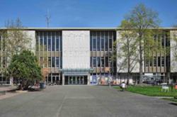
Embed here photo 3: Burnaby Caption: Deer Lake Park bounds a Burnaby, B.C. neighbourhood.
A two-part strategy -- where natural systems are protected and formed into linked natural areas and parks, which are then to be layered together with rational interconnected streets -- is certainly as simple. But the contingencies of place, an automatic outcome of a revealed natural system, provide the potential for great beauty over the full extent of metropolitan-scale urban landscapes. In short, it almost designs itself.
Linked parks strategy 5: Provide an alternative movement system
Linked parks and natural areas, by their nature, should connect all parts of a district. In the Damascus plan, the continuous network of parks and natural areas includes avenues for various modes of travel, from bike paths to footpaths to "pleasure vehicles only" parkways to rough walking trails that bring users closest to untrammelled nature.
This continuous system provides the potential for users to reach all parts of the district without using conventional streets at all. Such a secondary system can considerably reduce auto dependence and provide a resilient connective tissue capable of accommodating movement in future decades regardless of future limits on car use or skyrocketing fuel costs.
Our water footprint
At the heart of a healthy urban region is water -- water that moves through the veins and arteries of the urban watershed.
While the fight to reduce our GHG footprint is now at the height of urgency, reducing our water footprint remains crucial as well. Just as the atmosphere, the air itself, may not support human life as we know it unless we acknowledge our role in its destruction, so too are we as a species on the point of irreversibly corrupting the other life support system of the planet: its water.
A system of linked natural areas and parks is easily the most cost efficient and effective means of reversing the corruption to natural systems caused by cities.
Using a natural areas and parks strategy to manage the environmental consequences of city building has a corollary with the creation of neighbourhood quality, its sense of place.
Neighbourhoods bounded and protected by nature provide children with ready access to natural areas and to an explanation for how their world works. This is beyond price.
Not only does a linked system of natural areas and parks put nature at our doorstep, but it also provides verdant avenues for moving through the landscape -- a way of travelling that is both safe and delightful.
The benefits of a system of linked natural areas and parks are thus manifold. But, like all sustainability issues, it is a fatal mistake to focus on just one element of the puzzle at the expense of all others.
The paradigm shift
The secret lies in designing for all of the sustainability issues at the same time. A societal paradigm shift is required, one where it becomes commonplace to work collaboratively and holistically, rather than boxing ourselves into narrow technical, environmental or economic silos.
When this happens, when a community is designed in an integrated way, water will inevitably be at its heart. And when that collaboration occurs, it will be expressed in physical form in a linked system of parks and natural areas.
This North American planning tradition, too long moribund, can and should be revived. It is now foolish to ignore the myriad of benefits -- social, economic and ecological -- that accrue.
Tomorrow: Rule 7 -- Invest in lighter, greener, cheaper, smarter infrastructure. ![]()
Read more: Urban Planning + Architecture


Tyee Commenting Guidelines
Comments that violate guidelines risk being deleted, and violations may result in a temporary or permanent user ban. Maintain the spirit of good conversation to stay in the discussion.
*Please note The Tyee is not a forum for spreading misinformation about COVID-19, denying its existence or minimizing its risk to public health.
Do:
Do not: